Bell tower
| Bell tower | ||
|---|---|---|
|
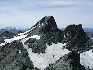
Bell tower from the northeast, from the Rifflkarspitze |
||
| height | 3353 m above sea level A. | |
| location | Tyrol , Austria | |
| Mountains | Ötztal Alps | |
| Dominance | 6.19 km → Weißseespitze | |
| Notch height | 388 m ↓ Weißseejoch | |
| Coordinates | 46 ° 53 '37 " N , 10 ° 39' 57" E | |
|
|
||
| First ascent | 1853 by the surveyor and first lieutenant Pöltinger, 1870 by Franz Senn with guide Gabriel Spechtenhauser | |
| Normal way | Kaunertaler Gletscherstraße - Riffltal - Riffljoch - Glockturm | |
The bell tower is a 3353 m above sea level. A. high mountain in the Ötztal Alps in the Austrian state of Tyrol . It is the highest peak of the bell tower ridge that runs from south to north . The mountain drops steeply to the northwest, west and southwest, but rather flat to the east. Due to its easy accessibility from the Kaunertal Glacier Road , it is a popular destination for mountain hikers and ski tourers . The bell tower was first climbed in 1853 as part of the military survey of the country by a Lieutenant Pöltinger, the first touristic inspection was undertaken in 1870 by Pastor Franz Senn from Vent and the mountain guide Gabriel Spechtenhauser on the south side.
Location and surroundings
The bell tower is located at the southern, higher end of the bell tower ridge, a mountain range in the Ötztal Alps . On the eastern flank of the mountain, the Rifflferner glacier, inclined at around 25 °, stretches up to a height of 3300 meters. To the west below the summit is the Glockturmferner, which has become an insignificant firn field due to the melting of the glaciers . Neighboring mountains are in the northeast, separated by the Riffljoch at an altitude of 3146 m , the Rifflkarspitze at 3219 m , in the southeast the Habicht ( 3092 m ) and in the southwest the 3146 m high Matternturm .
Tourist development
The Hohenzollernhaus in Radurschltal , located to the northwest at an altitude of 2,123 meters , southeast of Pfunds and the Gepatschhaus (1928 m) on Kaunertaler Gletscherstraße , located northeast in the rear Kaunertal , serve as bases for ascent of the bell tower . There is no clear normal route up the mountain. The ascent over the east side and the south-east ridge leads from the Gepatschhaus in, according to literature, five hours of walking over scree, moraines and blocks to the summit cross , some of which are marked with cairns . A variant leads in a little less time from the parking lot on the street (2400 m), a good five kilometers by road southwest of the Gepatschhaus through the Krummgampental to the summit. An easy block climb with difficulty level UIAA I leads over the northeast ridge of the bell tower. Since 1912 there has been serious climbing in 18 pitches on the west face , with a key point UIAA V and several points UIAA IV +.
Individual evidence
- ↑ Clem Clements, Jonathan de Ferranti, Eberhard Jurgalski , Mark Trengove: The 3000 m SUMMITS of AUSTRIA - 242 peaks with at least 150 m of prominence , October 2011, p. 7.
- ↑ Federal Office for Metrology and Surveying Austria: Glockturm on the Austrian Map online (Austrian map 1: 50,000) .
Literature and map
- Walter Klier : Alpine Club Guide Ötztaler Alpen Bergverlag Rudolf Rother, Munich 2006, ISBN 3-7633-1123-8
- Alpine Club Map 1: 25,000, sheet 30/4, Ötztal Alps, Nauderer Mountains

