Strict
|
Strict
|
||
|---|---|---|
| coat of arms | Austria map | |
|
|
||
| Basic data | ||
| Country: | Austria | |
| State : | Tyrol | |
| Political District : | Landeck | |
| License plate : | LA | |
| Surface: | 23.16 km² | |
| Coordinates : | 47 ° 8 ' N , 10 ° 28' E | |
| Height : | 1012 m above sea level A. | |
| Residents : | 1,240 (January 1, 2020) | |
| Population density : | 54 inhabitants per km² | |
| Postal code : | 6571 | |
| Area code : | 05447 | |
| Community code : | 7 06 27 | |
| NUTS region | AT334 | |
| Address of the municipal administration: |
Dorf 12a 6571 Strengen |
|
| Website: | ||
| politics | ||
| Mayor : | Harald Sieß (General Forward Stricts) | |
|
Municipal Council : (2016) (13 members) |
||
| Location of Strengen in the Landeck district | ||
| Source: Municipal data from Statistics Austria | ||
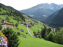
Strengen is a municipality with 1240 inhabitants (as of January 1, 2020) in the district of Landeck in the state of Tyrol ( Austria ).
geography
The municipality of Strengen consists of the main town and several scattered hamlets, which are mainly located on the northern slope of the Stanzer Valley .
Community structure
The community is located in the judicial district of Landeck .
Neighboring communities
| Zams | ||
| Flirsch |

|
Grin |
| Kappl | Tobadill |
history
Strengen lies between Landeck and the Arlberg , on an old Roman road . The townscape with its mixture of Romanesque walled houses and Bavarian wooden houses is still quite well preserved. According to Karl Finsterwalder, there was a certain Jakob der Streng in 1336 , from which the place name Strengen could be traced back. In Peter Anich's Atlas Tyrolensis from 1774, the place is mentioned as Gstreng , which etymologically could also have a pre-Roman or Romanesque origin of the field name . In the work Schematismus von Tirol und Vorarlberg from 1839 a distinction is made between the village of Strengen and the hamlets of "Rallsberg".
In the Middle Ages the community was called Rall , together with Flirsch Rallsberg . The original farms or hamlets were: Ausser- and Innergrießhof (1754: 7 houses); Balzerlen, Blahen, Blasgen and Brunnen (1754: 19 houses, 1837: 8 houses); Bühele, Dichten and Egg (1754: 3 houses); Courtyard (1754: 18 houses); Klaus and Loch (1754: 5 houses); Loret (1754: 1, 1837: 3 houses); Obermühl and Obweg (1754: 4 houses); Unterweg (1754: 17 houses); Perflör (1754: 3 houses); Riefen (1754: 14, 1837: 9 houses); and Verill (1754: 7, 1837: 7 houses). The capital Strengen itself had eight houses in 1754, and in 1837 up to 145 houses. Since then the community has also been called "Strengen am Rallsberg". 100 years later, with the construction of the Arlbergbahn, the name Rallsberg fell away. Since then, the community has been called Strengen am Arlberg .
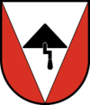
coat of arms
Culture and sights
- Catholic parish church Strengen hl. Martin
- Covered wooden bridge over the Rosanna from 1764, with a span of 18 m.
- A specialty in the Stanzer Tal were several of the last “ bell forges ” in Tyrol, where cowbells were handcrafted. Their sound should differ from machine-generated ones. The last two companies in the village closed down a few years ago. The now only active master bell forge in Austria works in Pettneu am Arlberg .
economy
Most of the working people are currently commuting, and unlike the communities in the Stanzer Tal near St. Anton am Arlberg , tourism is not very well developed.
traffic
- Road: For decades, the center of the village in the narrow valley floor in particular suffered from an enormous amount of traffic. With the construction of the Strenger Tunnel on the Arlberg Schnellstraße and its opening in June 2006, the volume of traffic was greatly reduced.
- Rail: Strengen has an Arlbergbahn station , but local rail transport in the Stanzer Valley has been greatly reduced, and public transport is handled by regional buses.
Personalities
- Simon Alois Maaß (1758–1846), priest, "the old Fließer pastor"
- Norbert Strolz (1922–1990), painter
Web links
- Maria-Hilf Chapel of Grace
- 70627 - Strict. Community data, Statistics Austria .
Individual evidence
- ^ Tyrolean onomastics (1978) Google Books
- ^ Schematism of Tyrol and Vorarlberg (1839) Google Books
- ^ Historical local dictionary Tyrol. Statistical documentation on population and settlement history (2014) PDF document ( Memento of the original dated December 16, 2011 in the Internet Archive ) Info: The archive link was inserted automatically and has not yet been checked. Please check the original and archive link according to the instructions and then remove this notice.
- ↑ Schellenschmied schellenschmied.at, accessed September 1, 2019. - Photo report on the work of the last old Schellenschmiede operated in Austria in Pettneu am Arlberg .


