Grin
|
Grin
|
||
|---|---|---|
| coat of arms | Austria map | |
|
|
||
| Basic data | ||
| Country: | Austria | |
| State : | Tyrol | |
| Political District : | Landeck | |
| License plate : | LA | |
| Surface: | 21.09 km² | |
| Coordinates : | 47 ° 8 ' N , 10 ° 31' E | |
| Height : | 1006 m above sea level A. | |
| Residents : | 1,366 (January 1, 2020) | |
| Population density : | 65 inhabitants per km² | |
| Postcodes : | A-6591 | |
| Area code : | 05442 | |
| Community code : | 7 06 07 | |
| NUTS region | AT334 | |
| Address of the municipal administration: |
Grin No. 57 A-6591 Grin |
|
| Website: | ||
| politics | ||
| Mayor : | Thomas Lutz | |
|
Municipal Council : (2016) (13 members) |
||
| Location of Grins in the Landeck district | ||
 Center of Grins |
||
| Source: Municipal data from Statistics Austria | ||

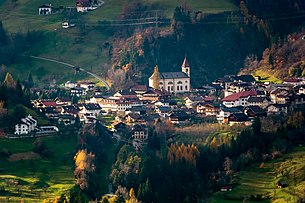
Grins is a municipality with 1,366 inhabitants (as of January 1, 2020) in the district of Landeck , in the state of Tyrol ( Austria ). The community is located in the judicial district of Landeck .
geography
Grins is located in the Stanzer Valley at the western end of a terrace above the Landecker basin, above the Sanna river (as the confluence of Rosanna and Trisanna ). The cluster village lies at the foot of the 3036 m high Parseierspitze .
The districts are Grins, Innerdorf, Ausserdorf, Fals, Cupier, Graf, Gurnau, Grist, Ochsenberg, Pazol, Gmar (since 2000).
The neighboring communities are Landeck , Pians , Stanz bei Landeck , Strengen , Tobadill , Zams .
history
Because of its sunny climate, Grins was already settled in prehistoric times, as is shown by finds from the Neolithic Age (around 2000 BC). The place was first mentioned in a document in 1288 as "Grindes".
Above Grins there is a healing spring that used to be much visited, and Margarete von Tirol is said to have stayed there several times.
In the Middle Ages , Grins was still an important base for traffic to the Arlberg , but since the construction of the Talstrasse in the 14th century, Grins has been on the sidelines. As a result, the village center was preserved in its Rhaeto-Romanic-nested settlement style.
In 1945 most of the place burned down and was partly rebuilt true to the original.
Grins has changed from a rural-tourist community to a residential and commuter community.
coat of arms
The municipal coat of arms was awarded in 1976 by the Tyrolean provincial government. It shows in stylized form the characteristic Roman bridge as a landmark of the place and as a symbol for the location on the Arlberg route.
Culture and sights
- The late baroque parish church was built in 1775–1779 in place of an older church and later redesigned and renovated several times, the ceiling fresco is by Matthäus Günther .
- The brick Roman bridge that spans the Mühlbach gorge in the center of the village actually dates from the 16th century, but probably got its name from the old Roman road that ran through the village.
Infrastructure
Grins is connected to the Landeck-Zams train station and thus to the Arlbergbahn by bus. The closer Pians train station, like all stops between Landeck and St. Anton, is no longer served.
Furthermore, the place is connected to the S16 Arlbergschnellstraße with the junction "Landeck-West" , which turns into the A12 Inntalautobahn towards Innsbruck and is used by many Grinner commuters.
Recreational facilities
Grins has an outdoor swimming pool , which is located on the upper edge of the village ("in the Fals"). There is a tennis court only a little below it . The well-known sulfur healing spring Wildbad lies above the village and can be reached by a twenty-minute walk or by mountain bike . On the eastern edge of the village is the soccer field of FC Grins and a little further behind at Grünbach there is a Kneipp facility .
Others
The residents of Grins do not call themselves "grinsers", but rather "grinners".
Sons and daughters of the church
- Michael Lechleitner († 1669), sculptor
- Ingenuin Lechleitner (1676–1731), sculptor
- Ferdinand Mungenast (1849–1911), architect
- Ignaz Waibl (1661–1733), wood sculptor and carver
Web links
- Website of the community of Grins
- www.geschichte-tirol.com: Grin
- 70607 - Grin. Community data, Statistics Austria .
Individual evidence
- ^ Eduard Widmoser: Tiroler Wappenfibel . Tyrolia-Verlag, Innsbruck 1978, ISBN 3-7022-1324-4 , p. 47 .


