
Nauders
|
Nauders
|
||
|---|---|---|
| coat of arms | Austria map | |
 |
|
|
| Basic data | ||
| Country: | Austria | |
| State : | Tyrol | |
| Political District : | Landeck | |
| License plate : | LA | |
| Surface: | 90.18 km² | |
| Coordinates : | 46 ° 54 ' N , 10 ° 30' E | |
| Height : | 1394 m above sea level A. | |
| Residents : | 1,535 (January 1, 2020) | |
| Population density : | 17 inhabitants per km² | |
| Postcodes : | 6542, 6543 | |
| Area code : | 05473 | |
| Community code : | 7 06 15 | |
| NUTS region | AT334 | |
| UN / LOCODE | AT NDS | |
| Address of the municipal administration: |
Nauders 221 6543 Nauders |
|
| Website: | ||
| politics | ||
| Mayor : | Helmut Spöttl (List Nauders - LN) | |
|
Municipal Council : (2016) (13 members) |
||
| Location of Nauders in the Landeck district | ||
  |
||
 View of Nauders from Norbertshöhe |
||
| Source: Municipal data from Statistics Austria | ||

Nauders ( Romansh ) is a municipality in the district of Landeck in the state of Tyrol ( Austria ). It is located at an altitude of 1394 m above sea level. A. , has 1535 inhabitants (as of January 1, 2020) and has 4200 beds for tourists. The municipality extends over an area of 90.3 km². Most of the inhabitants of Nauders make a living from agriculture and tourism, in summer and - above all - in winter. The municipality is part of the Landeck judicial district .
geography
Nauders lies in a high valley that is drained from the Stillebach to the Oberinntal . This high valley is clearly separated from the Upper Inn Valley by the Finstermünz Pass in the north , while the watershed towards the Adige Valley on the Reschen Pass in the south is an easily passable saddle . That is why Nauders is attributed to the Vinschgau , especially in historical contexts . The borders of Austria , Switzerland and Italy meet at the “three-country boundary stone” ( 2180 m ) in the southwest of the municipality . In the adjacent Samnaun valley is the small hamlet of Noggels , which is an exclave of Nauders. The heavily terraced terrain indicates what was once intensive agriculture.
The Black Lake and the Green Lake are southwest of Nauders .
Nauders has road connections to the Austrian Inntal (municipality of Pfunds ) and the Swiss Inntal ( Engadin ) to the Martina / Martinsbruck district of the municipality of Valsot and to the Vinschgau in South Tyrol (Italy).
climate
|
Average monthly temperatures and precipitation for Nauders
|
|||||||||||||||||||||||||||||||||||||||||||||||||||||||||||||||||||||||||||||||||||||||||||||||||||||||||||||||||||||||||||||||||||||||||||||||||||||||||||||||||||||||||
Neighboring communities
To the south of Nauders, following the Reschenpass , lies the neighboring village of Reschen am See ( Italian Resia ) in Vinschgau (South Tyrol, Italy), which belongs to the municipality of Graun . It is located at 1500 m above sea level at the northern end of Lake Reschen . The economic base of the 900-inhabitant village is mainly tourism and agriculture with cattle breeding and dairy farming, which can be seen in the landscape.
To the north of Nauders, following the Upper Inn Valley, lies the neighboring municipality of Pfunds , which is also a two-season tourist municipality that benefits from the nearby ski areas in Samnaun ( Switzerland ) and Nauders. The Nauderer exclave Noggels in the northwest also borders the municipality of Spiss .
The small village of Martina (114 inhabitants) is located southwest of Nauders, directly across the border with Switzerland, which belongs to the municipality of Valsot ( Canton of Graubünden ). The main branches of business are agriculture and the service industry (including customs and border guards).
Surrounding mountains
The mountains around Nauders are part of the Ötztal Alps and border on the Geigenkamm in the southeast with Tscheyeck ( 2666 m ) and Gueserkopf ( 2740 m ) , in the east are the Kleine Schafkopf ( 2742 m ) and the Piengkopf ( 2789 m ). In the southeast, Großer Schafkopf ( 3001 m ), Wölfeleskopf ( 2893 m ), Mataunkopf ( 2893 m ), Plamorter Spitze ( 2982 m ), Klopaierspitze ( 2918 m ) and Bergkastelspitze ( 2913 m ) form the border area with Italy. The Piz Lad ( 2808 m ) - Nauder's local mountain - belongs to the Sesvenna group and is not in the municipality, but on the border between Switzerland and Italy . The Middle Seekarkopf is Nauder's largest mountain.

Tscheyegg ( 2666 m )

Gueserkopf ( 2740 m )

Piz Lad ( 2808 m )

Swiss side of the Inn Valley
Bergkastelspitze ( 2913 m )

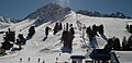
View of Nauders


history

Nauders is located on the Reschenpass (1507 m), over which the Via Claudia Augusta Roman road , which was opened around the year 50 and led from the Roman Empire to Augsburg . Nauders is probably the Roman street station "Inutrium", already drawn in the 2nd century on a map found in Alexandria on the Via Claudia Augusta, and was first mentioned as "Nuders" in the registry of the Benedictine monk Goswins von Marienberg in a document dating from 1149/52 mentioned. In 200 AD, the Roman road - and thus also the Nauders road station - lost its importance, as the Brenner was expanded and fortified by the Romans and as a result the Via Claudia Augusta replaced the most important trade route up to that point. At least since 1300 it was a customs post on this important north-south connection. The town center shows a strong Rhaeto-Romanic influence.
In the 10th century Nauders became one of the dishes of the County of Vinschgau. The Naudersberg court was a high and blood court, the penalties were carried out south of Nauders, where the meadows there are still today called 'Beim Hohen Gricht' . The authority of the caretaker and judge extended from the Lower Engadine to Zernez, over the Reschenpass and to Finstermünz. In his role as a court, Nauders got caught up in the dispute between the Habsburgs and the Engadines . After failing to pay interest to Naudersberg in 1475 on the part of the Engadin, a two-year war arose, which was mainly fought in the fields (so-called Engadin Wars ). However, Naudersberg Castle was also affected. The peace of Basel in 1499 brought peace. The Naudersberg court existed until the division of Tyrol in 1919; the area was then subordinated to the district court in Ried .

When the plague spread across Europe in the 14th century, Nauders was not spared. In 1348 the village was depopulated except for a few inhabitants. In 1609 Nauders was buried in an avalanche, 22 houses were torn away. In 1871 a mudslide ( debris avalanche ) coming from the Gamoar valley caused great damage in the upper village. In 1880 a big fire raged in which burned 83 houses and 72 farm buildings.
Even the Napoleonic era did not pass Nauders without traces. In 1799 the French invaded the village during the Second Coalition War between France , Austria , Prussia and Russia . The consequences were looting, the destruction of the facilities and the destruction of food supplies.
From 1872 to 1881 Franz Senn was pastor in Nauders. A monument is dedicated to the founder of the Alpine Club in the center of the village.
Nauders was part and seat of the judicial district of Nauders until the end of 1920 , which however was dissolved as a result of World War I and added to the judicial district of Ried in Tyrol . Since 1978 the municipality has been part of the Landeck judicial district.
population

According to the current data sheet - Population Nauders 2001 had a population of 1536 inhabitants. The number grew by 3.3% from 1991 to 2001. The sexes are roughly equal at 50.5% men and 49.5% women . On average, 2.8 people lived in one household . The composition of the families looked like this: a quarter of all families were couples without children, almost 60% of all families were couples with children, 13.6% were single mothers and only 1.7% were single fathers (see diagram).
Culture and sights
- Naudersberg Castle with Leonhard's Chapel
- Catholic parish church Nauders hl. Valentin with cemetery, cemetery chapel and Widum
- Mariahilfkirche
- Former hospital church of the Holy Spirit
- Chapel of St. Anthony south of the parish church
- Chapel of the Assumption of Mary near the Finstermünz dam
- Karl Borromeo Chapel in Hochfinstermünz
- Chapel of St. Martin at the Tiefhof
- Chapel of the Sorrowful Mother of God of the Mills (Mühlenkapelle)
- Nauders roadblock
- Kajetans Bridge
- Border fortress Altfinstermünz with the Assumption of Mary chapel
- Plamort anti- tank barrier
Yards
There are some old farms outside the built-up area:
The Tiefhof is located southwest of Nauders below Piz Lad at an altitude of 1574 m . The farm can be easily reached via a 2.5 km long paved road. The farm is located in the deep forest, which is criss-crossed by lakes and raised bogs. He has a house, a stable, a barn and his own chapel.
The mountain inn or the Riatsch snack station can be reached via the same path as the Tiefhof and is at an altitude of 1522 m . Said street can be used as a toboggan run from Riatsch in winter. Home-made Tyrolean dishes are offered in the mountain inn.
The Stableshof lies southeast of Nauders on 1816 m altitude and can be reached by road from the village center.
The Novelles snack bar is located to the west above Nauders at an altitude of 1600 m . Access by car is possible in summer. In winter you can use this 3 km long road as a toboggan run. There dishes from their own production are offered.
The Parditschhof is located north of Nauders at an altitude of 1600 m . It can be reached via the road that leads from the parish church through the upper village and branches off to the left. In winter this street can also be used as a toboggan run. From the yard you have a good view of the valley. Homemade Tyrolean food is also offered there.
The abandoned Kompatschhof lies south of Nauders at an altitude of 1620 m . It is located in the Kompatschwald on the border with Italy. The courtyard burned down in 2007, only the small chapel has been preserved.
Black Lake natural monument

The Black Lake is a natural monument above Nauders between the Kleiner and Großer Mutzkopf at an altitude of 1725 m .
Cycle path on a historic route
Nauders is on the long-distance cycle path , which runs as the Via Claudia Augusta along an ancient Roman road of the same name .
economy
Nauders as a base for haulage traffic has a long tradition in tourism. The reorientation towards winter tourism with the Bergkastel ski area was accompanied by a structural redesign of the village. Today the municipality is a two-season tourist area. It is therefore not surprising that half of all jobs in Nauders are in the hotel and restaurant sector. However, only 30% of all Nauders residents work in this industry.
In summer there are 300 km of marked hiking trails, 700 km of cycle and mountain bike trails and 95 km of marked running paths. The levels of difficulty range from easy valley hiking trails to via ferratas. In addition, there is the Bergkastel cable car and the chair lift, which is open in summer, which make the ascent easier.
In winter there are 90 km of cross-country ski trails, 111 km of ski slopes, 110 cleared winter hiking trails and 70 km of snowshoe trails available. The winter sports offer also includes a halfpipe , two ski schools, three ice rinks, an ice stock rink and 5 toboggan runs, three of which are illuminated and the longest is 8 km long.
Mountain railways


The Nauders ski area has a total of 12 lifts, including 1 cable car, 5 drag lifts, 1 pommel lift and 5 chair lifts.
The Bergkastelbahn begins two kilometers south of Nauders on Alter Strasse and Reschen Strasse . This monocable gondola runs 2850 m in a south-easterly direction, was built in 1974 with 4-person cabins and converted to 6-seater in 1990. During the conversion and expansion of the valley station into a service center, the roof top was celebrated in August 2015 , but a fire broke out on October 21, 2015.
politics
The municipal council has a total of 13 members.
- With the municipal council and mayoral elections in Tyrol in 2010 , the municipal council had the following distribution: 4 Nauders list, 4 Nauders home list, 2 Nauders young list, 2 We for Nauders, and 1 Nauders village community.
- With the municipal council and mayoral elections in Tyrol in 2016 , the municipal council has the following distribution: 6 Nauders list, 3 We for Nauders, and 4 Nauders community list.
- mayor
- 2004–2016 Robert Mair (Nauders home list)
- since 2016 Helmut Spöttl (Nauders List)
coat of arms
The municipal coat of arms is split into silver and red and features two upright fish facing away from each other in mixed up colors.
It was introduced on July 27, 1976. Accordingly, the colors of the municipality flag are white and red. The fish go back to Kuno Ritter von Nauders (1299) and Konrad Vischer (1583), keeper on Naudersberg, as both had these animals in their coat of arms.
Personalities
- Sons and daughters of the church
- Gottfried Purtscher (1767–1830), scholar, brilliant theologian, canon lawyer, founder and first rain of the seminary in Chur
- Jacob Bartholomäus Kleinhans (1774–1853), picture carver; went blind as a child, nevertheless created u. a. 300 crucifixes known throughout Europe
- Johann Nepomuk Kravogl (1803–1873), painter and lithographer
- Karl von Blaas (1815-1894), painter
- Johann Ofner (1816–1887), politician ( German Liberal Party and its successor parties), member of the Lower Austrian state parliament and the Reichsrat , mayor of St. Pölten .
- Hans Tschiggfrey (1904–1963), politician ( ÖVP ), governor of Tyrol
- Ernst Hairer (* 1949), mathematician
- Honorary citizen of the community
- Ludwig Thoma (1930-2015)
literature
- Landeck, Nauders, Samnaun group (map) . KOMPASS maps, Innsbruck (March 2006), ISBN 3-85491-048-7 .
Web links
- State of Tyrol - Old Linden tree natural monument
- State of Tyrol - Black Lake natural monument
- Background information on the border fortress Finstermünz on the homepage of the Altfinstermünz association
- 70615 - Nauders. Community data, Statistics Austria .
- www.geschichte-tirol.com
Individual evidence
- ↑ Martin Bitschnau , Hannes Obermair : Tiroler Urkundenbuch, II. Department: The documents on the history of the Inn, Eisack and Pustertal valleys. Vol. 2: 1140-1200 . Universitätsverlag Wagner, Innsbruck 2012, ISBN 978-3-7030-0485-8 , p. 63 No. 449 .
- ↑ Data sheet - Population Nauders. Institute for Geography at the University of Innsbruck, accessed on October 31, 2013 .
- ↑ Bergkastelbahn , youtube video (03:51), by Parkbenbewohner, March 9, 2014, accessed October 21, 2015.
- ↑ New valley station in Nauders in Vollbrand , orf.at, October 21, 2015, accessed October 21, 2015.
- ↑ Nauders: New valley station in Nauders was in full fire , tt.com - Tiroler Tageszeitung Online, October 21, 2015, accessed October 21, 2015.
- ↑ Obituary notice with 12 honorary posts
Flags | Fendels | Fiss | Flow | Flirsch | Galtür | Grin | Ischgl | Kappl | Kaunerberg | Kaunertal | Kauns | Ladis | Landeck | Nauders | Pettneu am Arlberg | Pfunds | Pians | Prutz | Ried im Oberinntal | St. Anton am Arlberg | Schönwies | Lake | Serfaus | Spiss | Punching at Landeck | Strict | Tobadill | Tosses | Zams