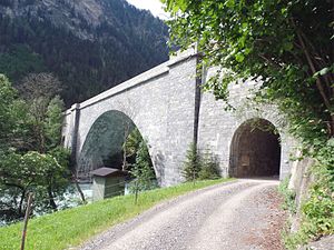
Kajetans Bridge
Coordinates: 46 ° 57 ′ 6 ″ N , 10 ° 30 ′ 42 ″ E
| Kajetans Bridge | ||
|---|---|---|
| use | Road bridge | |
| Convicted | Reschenstrasse | |
| Crossing of | Inn | |
| place | approx. 4 km southwest of Pfunds | |
| construction | Arch bridge | |
| completion | 1956/57 | |
| location | ||
|
|
||
| Above sea level | 991 m above sea level A. | |
The Kajetansbrücke is a stone arch bridge over the Inn in the municipality of Pfunds in Tyrol .
history
In 1854, the construction of the Hochfinstermünzstraße to Nauders , planned by Karl Ritter von Ghega, began (it corresponds to the current course of the Reschenstraße ). In the course of the new construction of the main road to Nauders, a wooden bridge was built at the point that was named after the governor of Tyrol at the time, Cajetan von Bissingen-Nippenburg . The original bridge had a large wooden arch over the mouth of the river, framed by stone arches on either side. Originally it was the largest self-supporting wooden bridge in Tyrol. Due to the increased traffic, the wooden arch was replaced by a reinforced concrete arch in 1956/1957.
From the Kajetansbrücke, the Roman Via Claudia Augusta leads as a hiking trail to the nearby Altfinstermünz , where the old road, coming from the Reschenpass , led across the Inn and where the customs post was. (The customs office was moved to Martina / Martinsbruck as early as 1779. ) The old street lost its importance with the opening of the Kajetansbrücke.
gallery
literature
- Hausmann, Wiesauer: road bridge, Kajetans bridge. In: Tyrolean art register . Retrieved March 9, 2016 .


