Klopaispitze
| Klopaispitze | ||
|---|---|---|
|
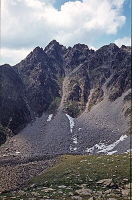
Klopaierspitze from the southeast, to the right of the summit is the couloir through which the ascent leads. |
||
| height | 2918 m above sea level A. | |
| location | Border Tyrol ( Austria ) / South Tyrol ( Italy ) | |
| Mountains | Ötztal Alps | |
| Dominance | 0.4 km → Plamorder peak | |
| Notch height | 60 m ↓ notch to the top of Plamorder | |
| Coordinates | 46 ° 50 '16 " N , 10 ° 32' 46" E | |
|
|
||
| Normal way | From the south through the southeast flank ( I ) | |
The Klopaierspitze (Italian: Piz Clopai , 2918 m above sea level ) is a summit in the main Alpine ridge and is located in the Nauderer Mountains , part of the Ötztal Alps . The summit forms the southwest corner pillar of this group. The summit also represents a special point in the border between Austria and Italy , because the border running from the west on the main Alpine ridge turns northeast at the Klopairspitze to the Bergkastelspitze , which is located in a northern side ridge of the main ridge.
Seen from Reschen in the upper Vinschgau , the Klopaierspitze is the dominant mountain in the east, because it obstructs the view of the higher Plamorderspitze ( 2982 m above sea level ) to the northeast, only half a kilometer away .
Routes
The easiest ascent leads from Graun into the depression northeast of the Grauner Berg ( 2526 m slm ). Alternatively, the trail leading over the Grauner Berg can be used with only a slightly higher expenditure of time . Now it goes in a large arc around the basin southeast of the summit, first over pastures, later over blockwork to the east side of the mountain. On the right edge of the distinctive gully, a little to the right (north) of the summit fall line, you get almost to the ridge and after an easy, short block climb from there to the summit. However, both the last passage and the summit area are exposed, which requires surefootedness and a head for heights . The channel is very steep and at risk of falling rocks. The climb from Graun takes about four hours.
literature
- Walter Klier : Alpine Club Guide Ötztal Alps. Bergverlag Rudolf Rother, Munich 2006, ISBN 3-7633-1123-8
Individual evidence
Web links
- www.seilschaft.it: Klopairspitze


