Little Piz Buin
| Little Piz Buin | ||
|---|---|---|
|
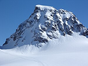
Little Piz Buin from the north, from the Ochsentaler Glacier. The Buinlücke is on the far left. |
||
| height | 3255 m above sea level A. | |
| location | Vorarlberg , Austria and Graubünden , Switzerland | |
| Mountains | Silvretta | |
| Dominance | 0.6 km → Großer Piz Buin | |
| Notch height | 199 m ↓ Buin gap | |
| Coordinates , ( CH ) | 46 ° 50 '32 " N , 10 ° 6' 45" O ( 803 924 / 191373 ) | |
|
|
||
| First ascent | August 24, 1868 by OW Stein and his guide Christian Jann. | |
| Normal way | Alpine tour | |
The Kleine Piz Buin ( Grisons Romansh Piz Buin Pitschen ) is a mountain in the Silvretta group on the border between Austria and Switzerland . At 3255 m above sea level A. it is the second highest peak in Vorarlberg after Piz Buin to the east .
The Kleine Piz Buin is also the sixth highest peak in the mountain range after the Piz Linard , the Fluchthorns , the Piz Buin , the Verstanclahorn and the Piz Fliana .
Location and surroundings
The Kleine Piz Buin is located in the main ridge of the Silvretta and, like the Große Piz Buin, marks the border between the Austrian state of Vorarlberg and Switzerland . It is separated from its better-known neighbor by the Buinlücke (3056 m). The Ochsentaler Glacier spreads north of the Kleiner Piz Buin and (as of 2018) extends to just below the Buinlücke.
The glacier forms the source of the Ill , which feeds the nearby Silvretta reservoir via its runoff through the Ochsental and later drains into the Rhine between Nofels and Meiningen . The Silvretta High Alpine Road , which connects the two Austrian states of Vorarlberg and Tyrol , runs along the banks of the reservoir over the 2032 m high Bielerhöhe . The parking facilities there and the bus connection represent the starting point for the approach to the Wiesbadener Hütte.
To the west, the Fourcla dal Cunfin separates the Kleiner Piz Buin from the 3210 m high signal horn . Over the pass, it is also possible to pass from the Ochsental Glacier to the Swiss La Cudera glacier, which spreads southwest of the mountain , whose glacier tongue formerly flows in the direction of the Tuoi Valley, also Swiss, which is located south of the Kleiner Piz Buin, a side valley of the Lower Engadine near Guarda .
Ascent
In contrast to its higher neighbor, the (large) Piz Buin, the small Piz Buin is rarely climbed. It can be done both in summer as an alpine tour and in winter as a ski tour .
The route of the first ascent led from the Silvrettahütte (2341 m) over the Silvrettapass to the summit. Further bases are the Wiesbadener Hütte (2443 m) in Vorarlberg over the Buinlücke and the west ridge in the north, from the south the Chamonna Tuoi (2250 m) over the La Cudera glacier.
The ascent of the Kleiner Piz Buin is in any case a glacier tour and requires climbing in difficulty level II , which, however, can be exceeded by the melting of the glacier, depending on the conditions.
Origin of name and history
The name Piz Buin is borrowed from Romansh and means something like ox head in German. This name is supplemented in Romansh with Grond for the large Piz Buin and Pitschen for the small Piz Buin. If the colloquial language only refers to “Piz Buin”, it usually means the Great Piz Buin, or Piz Buin Grond.
The first ascent of the small Piz Buin took place on August 24, 1868 by OW Stein and Christian Jann, about three years after that of the large Piz Buin. Their way led from Klosters over the Alp Spörra and Sardasca to the “Clubhütte”, today the Silvretta hut , as OW Stein describes in his report. From there they climbed over a cracked glacier in the direction of the Silvrettapass, where Stein and his guide, after taking a break at the Mittagsplatte (Plan da Mezdi), decided to climb the small Piz Buin due to the good weather. Stein reports a rugged rock ridge. A cairn was erected at the summit , which contained a bottle of paper with the names of the two first climbers. They chose the descent "in a northerly direction along the ridge".
OW Stein stated in his report the height of the summit at 3264 m.
swell
- ↑ a b German Alpine Association (Ed.): Alpine Association Map No. 26 Paths and Ski Tours . Edition 2018.
- ↑ Silvrettasee. Retrieved September 1, 2018 (Austrian German).
- ↑ Silvretta High Alpine Road. Retrieved September 1, 2018 .
- ↑ Arrival . In: Wiesbadener Hut . May 23, 2016 ( wiesbadener-huette.com [accessed September 1, 2018]).
- ↑ a b Piz Buin Pitschen 3256m. Retrieved September 1, 2018 .
- ↑ a b c Yearbook of the Swiss Alpine Club, fifth year 1868-1869 . Verlag der Expedition des Jahresbuch des SAC, Bern 1869, p. 391-408 ( google.de ).
- ^ Röhm Verlag und Medien GmbH & Co. KG: The ox head and its iconic name . August 8, 2015 ( bbheute.de [accessed September 1, 2018]).
- ↑ Detail of the first to climb. Retrieved September 1, 2018 .


