
Escape horn
| Fluchthorn, Piz Fenga | ||
|---|---|---|
 The three peaks of the Fluchthorn from the west. In the middle of the picture is the tooth yoke, on the right the crown (3187 m), referred to by Weilenmann as the "pseudo-escape horn". |
||
| height | 3399 m above sea level A. | |
| location | Tyrol , Austria and Graubünden , Switzerland | |
| Mountains | Silvretta | |
| Dominance | 15.5 km → Piz Linard | |
| Notch height | 647 m ↓ Fuorcla Zadrell | |
| Coordinates , ( CH ) | 46 ° 53 '26 " N , 10 ° 13' 38" O ( 812 478 / 197 047 ) | |
|
||
| First ascent | July 12, 1861 by Johann Jakob Weilenmann and Franz Pöll | |
| Normal way | Weilenmann channel ( II ) | |
| particularities | historically also: Grenzspitze, Wälsche Berg | |

The Fluchthorn ( Rhaeto-Romanic ) is a mountain range in the eastern Silvretta on the border between Austria and Switzerland . At 3398 m above sea level M. (Swiss measurement) or 3399 m above sea level. A. (Austrian measurement) the Fluchthorn is the second highest mountain in the Silvretta.
location
Politically, the Fluchthorn lies on the border between the Austrian municipality of Galtür and an exclave of the Swiss municipality of Valsot .
Orographically , the Fluchthorn belongs entirely to the Paznaun , so it is not a border mountain of the Engadine . Nevertheless, the flanks of the mountain drain through the Jamtal to the west and the Fimbatal to the east via Paznaun into the Inn and Danube rivers .
Linguistically, the Fluchthorn lies on the linguistic border between German and Rhaeto-Romanic .
height
The Fluchthorn is a three-peaked mountain range.
The Austrian Federal Office for Metrology and Surveying designates the three peaks as the Northern Fluchthorn , Middle Fluchthorn and Southern Fluchthorn , with the heights of 3309 m, 3397 m and 3399 m.
The national map of Switzerland only designates the southernmost peak, with the simple name Fluchthorn and the altitude indication 3398.0 m. The summit is used as a triangulation point .
The peak measurement varies not only according to the two countries involved, but also over time:
- In the 19th century, the Dufour map viewed the Mittlere Fluchthorn as the highest peak and noted a height of 3396 m. The continuation of the Dufour map up to the middle of the 20th century designated the southern Fluchthorn as the highest peak - according to today's knowledge and rightly - at 3403 m, i.e. 7 m higher than before. Position and height were identical to the Siegfried map of the same time period.
- The Siegfried map shows the height of the Middle Fluchthorn from 1898 to 1950 at 3402 m. The modern maps of the Swiss national topography indicate the altitude at 3397 m since 1951.
- The northern Fluchthorn on the Gratscheide towards Gamshorn and Gemspleisspitze is indicated on the Swiss maps at 3317 m, eight meters higher than on the Austrian maps.
The Fluchthorn is the highest point of the Austrian Silvretta and after the Piz Linard with 3411 m above sea level. M. the second highest peak of the Silvretta ever. The dominance of the mountain gives climbers a wide summit panorama.
The Heidelberg Section donated the summit cross in 1989 on the occasion of the 100th anniversary of their Alpine Club house at the foot of the mountain.
Surname
Escape horn
The mountain shares the German name Fluchthorn with the 3795 m high Fluchthorn in the Swiss canton of Valais . The name comes from the local hunter's language and refers to the hunted chamois' retreat .
In the 19th century, when this summit was considered the highest of the group of three, the Mittlere Fluchthorn was also called the Rennerspitze , after the Stuttgart Alpine pioneer E. Renner. Sometimes the name Grenzspitze was used in the past .
.jpg)
In 1774 the Fluchthorn along with the entire chain up to the Gemspleisspitze was referred to as Wälsch Berg on the maps of the Atlas Tyrolensis . However, today's Fimberalpe was also called the Wälsch Alpe there .
Piz Fenga
The Rhaeto-Romanic name Piz Fenga refers to the Val Fenga (German: Fimbertal ) lying to the east below the summit . As a counterpart, on the other side of the valley, there is the Piz Fenga Pitschna (literally Kleinfimberspitze ), which is only 2,725 m high and much more modest in appearance. In contrast to the Fluchthorn, the Piz Fenga Pitschna does not present an alpine challenge.
Glaciation
In the 19th century, the glaciers around the Fluchthorn were connected to one another to form a single glacier area: Larainferner , Fluchthornferner , Kronenferner and Vadret da Fenga . The crown was also surrounded by glaciers. Today, apart from the Larainferner, all glaciers have shrunk to relics, and the ice fields are no longer connected. In the glacier foreland of Fluchthorn Ferners a system of lakes has emerged with six mountain lakes.
First ascent story
Johann Jakob Weilenmann was a merchant from St. Gallen, Switzerland . He had long since noticed the Fluchthorn because of its shape, which dominates everything else in the area. From the mountains around St. Gallen he often observed that in the evening it was the last mountain to shine in the sun, from which he concluded that the massif was enormous. He also often observed it from Säntis and other peaks in Graubünden. So the desire grew in him to explore and climb this mountain. First he wanted to do this with a shepherd and cattle dealer who was active on the Vermuntalpe. Weilenmann traveled through the Montafon for the first ascent. Locals whom he asked about the Fluchthorn always showed him the way to Piz Buin , the highest mountain in the area known to them, as the Fluchthorn is not visible from the valley floor of the Montafon . However, the shepherd was unexpectedly visited by Swiss cattle traders, so that he turned down Weilenmann. He traveled on over the Zeinisjoch to Galtür and climbed the Gorfenspitze there to explore. As a second choice, he then hired Franz Anton Pöll, alias “Pöllele”, a farmer, shepherd and chamois hunter from the Paznaun hamlet of Valzur . He worked on the Larainalpe north of the Fluchthorn. Since there was no telephone or the like to make an appointment, Weilenmann Pöll had to look in the Lara valley. He climbed the Larainfernerspitze (3009 m).


There are conflicting sources on the day of the first ascent. Before sunrise on July 12, 1861, they set off, crossing the ridge between Fluchthorn and Gemsbleisspitze. Weilenmann, who often saw the Fluchthorn from the west and south, did not recognize it from the north. Therefore, he said that the crown (3187 m) south of the Zahnjoch is the Fluchthorn. This mistake is not entirely understandable from today's perspective, also due to the sufficiently precise Dufour map that Weilenmann used. However, like the Fluchthorn, the crown is a collection of jagged jagged points in a north-south direction. Not knowing that he was already very close to his goal, they walked along the eastern foot of the Fluchthorn to the Zahnjoch (2947 m) to reach the crown. Only on the yoke did he notice his mistake. From then on, Weilenmann referred to the crown as a "pseudo-escape horn". This mistake led the two of them - albeit more by chance - to the most suitable ascent, which led through the couloir later called Weilenmannrinne on the southern flank of the southern Fluchthorn. The gully, filled with snow, was dangerous for avalanches. Weilenmann was in extremely bad shape that day. It was more Pöll who led the way. Nevertheless, the two reached the summit around 10 a.m.
Access
Starting points for an ascent from the Tyrolean side are the Jamtalhütte in Jamtal and the Heidelberger Hütte in Fimber Valley.
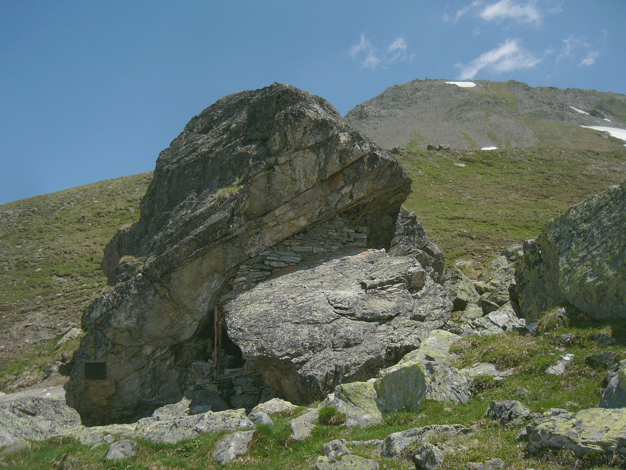
The path from the Jamtalhütte leads at 2480 m past the Finanzerstein , a boulder protected by a shelter hut , in the direction of the Zahnjoch. The base was related to the smuggling (including tobacco, coffee and saccharine ) over the nearby Futschölpass . Shortly before the Zahnjoch you reach the Weilenmanrinne. The path from the Heidelberger Hütte to the Zahnjoch was abandoned a few years ago and the signs were removed. The reason is the decline of the Vadret da Fenga. The official route from the Fimber Valley to the southern foot of the Fluchthorn now leads over the Kronenjoch south of the Krone.
You can also get to the southern foot of the Fluchthorn from Switzerland via the Futschölpass or the Tasnafurka.
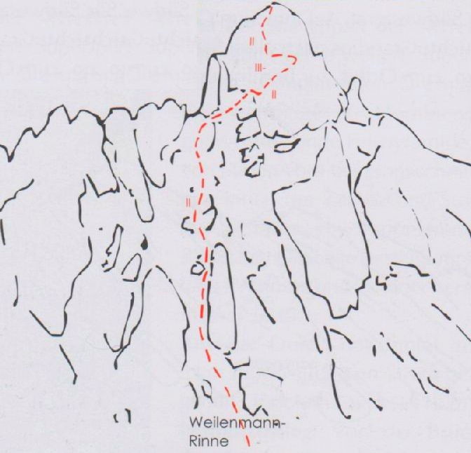
The final ascent begins at around 2900 m above sea level west of the Zahnjoch and usually leads through the steep and often snow-filled Weilenmann channel . The climbing sections in the summit area are of difficulty levels II and III.

The best season for an ascent is early summer. The best time of day is early in the morning because of the risk of falling rocks.
view
This extends in the east over the Ötztal Alps to the Stubai Alps, in the south to Care Alto , Ortler, Monte Disgrazia , Piz Bernina, and in the west to Monte Rosa , to the Matterhorn (222 km), Dom , Bietschhorn , Aletschhorn, Mönch and other well-known peaks of the Bernese Alps .
Web links
Individual evidence
- ^ Dufour map from 1853 to 1898.
- ^ Dufour map from 1899 to 1956.
- ^ Siegfried Card .
- ↑ Swiss national topography
- ↑ Summit panorama under MountainPanoramas, accessed on May 20, 2014.
- ↑ Explanatory board on the summit cross, see corresponding picture in the Commons
- ↑ a b Yearbook of the Swiss Alpine Club . 1866.
- ↑ Walther Flaig: The Silvrettabuch: People and Mountains over three countries: Vorarlberg, Tyrol, Graubünden . R. Rother, 1961.
- ↑ 46 ° 55 ′ 5 ″ N , 10 ° 16 ′ 57 ″ E
- ↑ National map of Switzerland. Time travel function.
- ↑ Date of the first ascent: August 19, 1861 according to ALPIN magazine 04/10 .
- ↑ a b Date of the first ascent: July 12, 1861 according to JJ Weilenmann: Aus der Firnenwelt. Munich 1929, quoted in http://www.heidelbergerhuette.com/erstbesteigung.html ( Memento from January 2, 2015 in the Internet Archive ) .
- ↑ a b Reinhard Braxmaier: Fluchthorn story (s) - From devil guys and alpine pioneers. On the occasion of the first ascent of the Fluchthorn 150 years ago by Franz Pöll and Johann Jakob Weilenmann on July 12, 1861. A contribution to the alpine and tourism history of the Paznaun. Publisher: Galtür Municipality, Alpinarium Galtür u. Swabia section of the DAV, 2011.
- ↑ Photo at Hikr, accessed on May 20, 2014.
- ↑ splendor and misery in the history of Galtür. ( Memento of September 24, 2015 in the Internet Archive ), accessed on May 22, 2014.
- ↑ Example from the press about smuggling via Futschölpass, accessed on May 22, 2014.
- ↑ Photo with route of the final attack on the Fluchthorn, accessed on May 20, 2014.
- ↑ Sketch of the final attack on the southern flank of the Fluchthorn, accessed on May 20, 2014.
- ↑ Route description at Hikr, accessed on May 20, 2014.
- ↑ PeakFinder Ltd [email protected]: mountain panorama: fluchthorn. Retrieved January 22, 2020 .