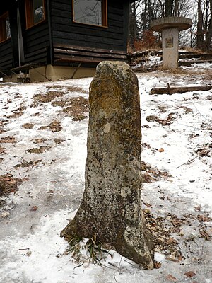
Dreifürstenstein
| Dreifürstenstein | ||
|---|---|---|
|
The triangular landmark of the 17th century on the Dreifürstenstein |
||
| height | 860.1 m above sea level NHN | |
| location | Baden-Wuerttemberg , Germany | |
| Mountains | Swabian Alb | |
| Coordinates | 48 ° 22 '23 " N , 9 ° 2' 38" E | |
|
|
||

A distinctive, 860.1 m above sea level is used as the Dreifürstenstein . NHN high mountain promontory on the northwest side of the Swabian Alb , which drops steeply on three sides and was actually a triangle until 1806 . The triangular border stone on the Albtrauf marked the border between the princely territories of Fürstenberg , Hohenzollern and Württemberg .
Today the projection forms a communal border point: two districts ( Tübingen and Zollernalbkreis ) and three cities ( Mössingen with the Belsen district , Burladingen with the Salmendingen district and Hechingen with the Beuren district ) border each other here.
From the Dreifürstenstein you have a very good view from Jungingen in the valley of the Starzel (the so-called Killertal ) in the south to Mössingen in the Steinlachtal in the north. In the vicinity of the boundary stone there is a log cabin (built in 1926), an orientation table (set up in 1978), a barbecue area with benches (built in 1977) and an information board (set up in 2005). A refuge was built in 1892, but it was destroyed in the First World War. The systems are looked after by the Swabian Alb Association. A fundamental renovation with the installation of the information board took place in 2005.
The popular destination can only be reached on foot. The Kornbühl with the Salmendinger Chapel and the well-known mountain slide area on the Hirschkopf are in the immediate vicinity .
The Dreifürstenstein is the highest point in the Tübingen district . The Dreifürstenstein School in Mössingen is named after him .
The legend of the Dreifürstenstein
The Dreifürstenstein became famous through a romantic legend : the three princes of Fürstenberg, Hohenzollern and Württemberg met once at the Dreifürstenstein to discuss. A round table was attached above the boundary stone. Each of the three princes who sat at the table thus remained on their territory. This table is said to have been made of sandstone and is mentioned in a Beuren local chronicle from 1867.
On special occasions on the Dreifürstenstein, such as the festivities of the Swabian Alb Association, the meeting of the princes is often re-enacted.
The legend probably first originated around 1850. It was around this time that the term Dreifürstenstein appeared. The name Scharfes Eck was used for the place until the 18th century . Even Gustav Schwab mentioned in his Albführer The Neckar side of the Swabian Alb from 1823, in which he describes the Alb and related announcements, neither the Dreifürstenstein nor the accompanying story. The legend probably originated in the middle of the 19th century as a result of the recollection and enthusiasm for the Middle Ages .
At this point the three-country border no longer existed. As a result of the reorganization of the territories in southwest Germany by Emperor Napoleon I , the Fürstenberg area on the Dreifürstenstein was added to the Prince of Hohenzollern-Sigmaringen in 1806 .


