
St. Gallenkirch
|
St. Gallenkirch
|
||
|---|---|---|
| coat of arms | Austria map | |
 |
|
|
| Basic data | ||
| Country: | Austria | |
| State : | Vorarlberg | |
| Political District : | Bludenz | |
| License plate : | BZ | |
| Surface: | 127.99 km² | |
| Coordinates : | 47 ° 1 ' N , 9 ° 58' E | |
| Height : | 878 m above sea level A. | |
| Residents : | 2,213 (January 1, 2020) | |
| Population density : | 17 inhabitants per km² | |
| Postal code : | 6791 | |
| Area code : | 05557 | |
| Community code : | 8 01 20 | |
| NUTS region | AT341 | |
| Address of the municipal administration: |
HNr. 4 6791 St. Gallenkirch |
|
| Website: | ||
| politics | ||
| Mayor : | Josef Lechthaler ( SPÖ ) | |
|
Local council : (2015) (21 members) |
||
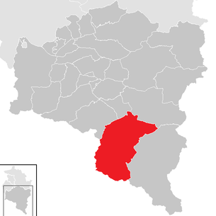
| Location of St. Gallenkirch in the Bludenz district | ||
  |
||
 Kirchdorf with the parish church St. Gallus |
||
| Source: Municipal data from Statistics Austria | ||

St. Gallenkirch is a municipality in the Austrian state of Vorarlberg with 2213 inhabitants (as of January 1, 2020). The embossed from the tourism community is located in Montafon in district Bludenz and is divided into the districts of St. Gallenkirch, Gargellen and Gortipohl .
geography
St. Gallenkirch is located in the south of Vorarlberg at an altitude of 878 meters. The main river is the Ill . With a municipal area of almost 128 km², St. Gallenkirch is the municipality in the state with the second largest area. 28.1% of this area is forested, another 47.1% belong to the high alpine area.
Districts
Orographically to the left of the Ill, in the west of the church village, is the district of Galgenul with the valley station of the Valiserabahn.
Behind it, about five kilometers along the Suggadinbach up the mountain, lies at an altitude of 1423 m above sea level. A. the small mountain village Gargellen with 127 inhabitants (as of January 1, 2020). The former Maisäss is the highest place in the Montafon. Gargellen is strongly influenced by tourism, there are a large number of hotels, guest houses, private rooms and holiday apartments.
In the valley of the church village, at an altitude of about 950 m above sea level. A. , is the village of Gortipohl with 653 inhabitants (as of January 1, 2020), a waterfall and its own parish church.
history
The Habsburgs ruled the places in Vorarlberg alternately from Tyrol and Upper Austria ( Freiburg im Breisgau ). From 1805 to 1814 the place, like all of Vorarlberg and Tyrol, belonged to Bavaria , then again to Austria . St. Gallenkirch has belonged to Vorarlberg since the state was founded in 1861.
In 1801 over 30 people, mostly children, died of smallpox and in 1920 dysentery occurred in St. Gallenkirch.
During the Second World War , many men of the community were mainly mountain troops in divisions in Norway and Yugoslavia . A human tragedy occurred in 1941 when two young Jewish women committed suicide while fleeing to Switzerland . The place was part of the French occupation zone in Austria from 1945 to 1955 .
Population development

The proportion of foreigners at the end of 2002 was 9.9 percent.
After decades of population growth, when the birth balance and migration balance were positive, emigration increased between 2001 and 2011. This led to a slight decrease in the population, which was stopped again in the years up to 2018.
Municipal coat of arms
The municipal coat of arms , a talking coat of arms , was created in 1966 based on a design by the Schruns artist and heraldist Konrad Honold . It shows St. Gallus (with his attribute, the bear), a church and the two crossed keys of the Montafon. The official description reads: A shield split in a gobble cut, in front in gold a monk figure (St. Gallus) clad in red with a silver walking stick in the left hand and a silver bread in the right hand, in front of a small silver bear, in the back one in green silver church covered in black and below in black two crossed silver keys.
politics
The community council of St. Gallenkirch has 21 members. After the municipal council elections in 2015 , the SPÖ list “Team Josef Lechthaler - Party-Free Citizens and SPÖ” had twelve and the ÖVP list “List Ewald Tschanhenz - St. Gallenkirch People's Party and Independents” had nine seats in the municipal council.
As mayor, Josef Lechthaler from the SPÖ replaced his predecessor Ewald Tschanhenz from the ÖVP in the 2015 direct election.
- -2010: Arno Salzmann (SPÖ)
- 2010–2015: Ewald Tschanhenz (ÖVP)
Economy and Infrastructure
In 2003 there were 68 commercial enterprises with 949 employees and 23 apprentices on site. There were 1,176 employees subject to wage tax. Tourism and tourism are important. In the tourism year 2007/2008 there were a total of 553,408 overnight stays, of which 387,354 in winter and 166,054 in summer.

Culture and sights
- Parish church St. Gallus in St. Gallenkirch: From 1307 a chapel stood here. The church was built in 1474, expanded in 1669 with a new tower.

- Kuratienkirche St. Nikolaus in Gortipohl: During the renovation of the church in 1959, a chronicle from 1854 was discovered when the church tower was re-roofed, which provides information about the time at that time.

- Kuratienkirche hl. Maria Magdalena in Gargellen: Presumably from 1411 a chapel stood at this place, and the church was built in 1615 by a foundation of Peter Lentsch . The structure of the side altar was created by David Bertle in 1674 .

- Balbierbach with waterfall in Gortipohl
- The Maisäß Montiel is still one of the few Montafon Maisäß settlements in its original state.

- The covered wooden bridge to Gargellen over the Ill at the Montafoner Hüsli.
education
In St. Gallenkirch and Gortipohl there is a kindergarten and an elementary school each, and the small district of Galgenul also has its own (one-class) elementary school. The Hauptschule Innermontafon of the communities St. Gallenkirch and Gaschurn is located in Gortipohl.
There were 239 pupils on site in the 2007/2008 school year, of which 86 children attend one of the three primary schools and 128 pupils attend the secondary school.
Personalities
- Honorary citizen
- Josef Feurstein (1887–1973), member of the state parliament and pastor
- Sons and daughters
- Erika Netzer (1937–1977), ski racer
- Fritz Rudigier (1941–2015), member of the Vorarlberg state parliament and mayor of St. Gallenkirch from 1985 to 2005.
- Ronald Stampfer (* 1976), ski racer
- People related to the place
- Gabriele Juen (* 1963), former member of the state parliament (ÖVP)
- Markus Schairer (* 1987), snowboard cross world champion 2009, SBX world cup overall winner 2008/09.
literature
- Josef Zurkirchen. Heimatbuch St. Gallenkirch - Gortipohl - Gargellen. 2nd edition 1997. ISBN 3-85430-101-4
Web links
- 80120 - St. Gallenkirch. Community data, Statistics Austria .
Individual evidence
- ↑ Statistics Austria - Population at the beginning of 2002–2020 by municipalities (area status 01/01/2020)
- ↑ a b Statistics Austria: Population on 1.1.2020 by locality (area status 1.1.2020) , ( CSV )
- ↑ Statistics Austria, A look at the community of St. Gallenkirch, population development. Accessed March 31, 2019 .
- ↑ Cornelia Albertani, Ulrich Nachbaur: Vorarlberg municipal coat of arms registry . Ed .: Vorarlberger Landesarchiv. 3. Edition. Bregenz 2011, ISBN 978-3-902622-17-4 , pp. 41 ( vorarlberg.at [PDF]).
- ↑ The new mayor faces. In: vorarlberg.orf.at. March 15, 2015, accessed October 22, 2017 .
- ↑ The Gortipohler Curatiechronik from 1854 (PDF; 57 kB)

Bartholomäberg | Blons | Bludenz | Bludesch | Fire | Bürs | Bürserberg | Dalaas | Fontanella | Gaschurn | Innerbraz | Klösterle | Lech | Lorüns | Ludesch | Nenzing | Nüziders | Raggal | St. Anton im Montafon | St. Gallenkirch | St. Gerold | Schruns | Silbertal | Sunday | Stallhr | Thuringia | Thuringian Mountain | Tschagguns | Vandans