
Silbertal
|
Silbertal
|
||
|---|---|---|
| coat of arms | Austria map | |
 |
|
|
| Basic data | ||
| Country: | Austria | |
| State : | Vorarlberg | |
| Political District : | Bludenz | |
| License plate : | BZ | |
| Surface: | 88.65 km² | |
| Coordinates : | 47 ° 6 ' N , 9 ° 59' E | |
| Height : | 889 m above sea level A. | |
| Residents : | 842 (January 1, 2020) | |
| Postal code : | 6782 | |
| Area code : | 05556 | |
| Community code : | 8 01 23 | |
| NUTS region | AT341 | |
| Address of the municipal administration: |
Center 256 6782 Silbertal |
|
| Website: | ||
| politics | ||
| Mayor : | Thomas Zudrell | |
|
Local council : (2015) (12 members) |
||
| Location of Silbertal in the Bludenz district | ||
  |
||
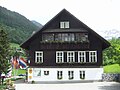
.jpg) View of the scattered settlement Silbertal (2009) |
||
| Source: Municipal data from Statistics Austria | ||

Silbertal is a municipality shaped by tourism with 842 inhabitants (as of January 1, 2020) in the Bludenz district in Vorarlberg ( Austria ).
geography
The place Silbertal is a scattered settlement and is located in the westernmost state of Austria, Vorarlberg, in the Bludenz district at 889 m above sea level. A. Höhe in the Silbertal in the Verwall group . Its name came about as a result of the copper and silver mining that used to take place there.
The municipality covers almost the entire Silbertal , a side valley of the Montafon through which the Litz flows. It extends far to the east and ends at the Silbertaler Winterjöchle (transition from the Silbertal to the Schön Verwall on the border between Vorarlberg and Tyrol ). The highest point of the municipality with 2869 m above sea level. A. lies on the southern Pflunspitze . Only the lower end of the Silbertal is shared by the neighboring communities of Bartholomäberg and Schruns , where the Litz enters the valley floor of the Ill. The valley has two smaller side valleys on the unpopulated upper course, the Gaflunatal with the Gaflunabach, and the Wasserstubental with the Burtschabach. Numerous other small streams flow into the Litz. 31.7% of the area is forested and 35% are Alps.
The mountain, which towers above the town in the east, is named accordingly Silbertaler Lobspitze ( 2605 m above sea level ).
The Silbertaler Straße ( Landesstraße 95) ends in the eastern part of the village, so that it does not suffer from through traffic. From there, forest roads begin to approach the numerous Alps.
Community structure
The community includes only one cadastral community and locality (Silbertal) . The spelling Siberthal , which was common up to the beginning of the 20th century, is found in older works .
Places are:
- Silbertal , the main town, a scattered settlement with the districts Innertal and Ausertal
- Kristberg , a scattered settlement on the southern slope of the valley, with the districts Innerkristberg and Auserkristberg
- Buchen , a scattered settlement east of Kristberg, with the associated parts of Unterbuchen, Oberbuchen and Innerbuchen .
- Ganlätsch , Höfle and Schöffel , three small groups on the northern slope across from Ausser Valley
- Fellimännle , around the inn into the valley, with the single location Im Ree
Alps are the Alpguesalpe, Fanesklaaalpe, Fresch (Untere Alpe Fresch), Giesela, Gretsch, Kapell (Innerkapell), Käfera, Muttalpe, Untere and Obere Dürrwaldalpe, Untere and Obere Gafluna, Untere and Obere Wasserstube, Platina, Putzkammer, Rona, Stöfeli . The Neue Reutlinger Hütte is also located in the municipality .
Neighboring communities
| Bartholomäberg | Dalaas | Kloesterle |
| Schruns |
.svg)
|
St. Anton am Arlberg ( Tyrol ) |
| St. Gallenkirch | Gaschurn |
history
Mining was already practiced here over 1000 years ago and the miners dug for silver, copper and iron on the heights of the Kristberghanges, which also explains the origin of the name: Silbertal was called "Silberberg" until the 17th century. The Romansh court disciples of the Bludenz court settled in the favorable locations on the valley floor.
The Silbertal was first settled by the Walsers who moved in between 1100 and 1200. The first evidence is provided by a documentary mention in 1319 and the consecration of the chapel in Silberberg by the Walser in 1332.
The entire Silbertal- Bartholomäberg area is a mining area that goes back to prehistoric times and experienced its last heyday in the High Middle Ages. With the discovery of the New World, around 263 tons of silver were transferred from America to Europe between 1520 and 1550, causing the price of silver to fall massively. Mining in Silbertal with 0.5 tons / year and Schwaz with 15 tons / year was no longer financially viable and came to a standstill.
Silbertal was the seat of its own Walser court until 1453 and came to Austria together with the Montafon in 1420 .
The Montafon had a certain independence until 1806 on the legal basis of the Montafon land custom (since 1554). The Habsburgs ruled the places in Vorarlberg alternately from Tyrol and Upper Austria (Freiburg im Breisgau). From 1805 to 1814 the place belonged to the Kingdom of Bavaria , then again to Austria . Since it was founded in 1861, Silbertal has belonged to (the Austrian crown land , then federal state ) Vorarlberg . The place was part of the French occupation zone in Austria from 1945 to 1955.
On the forecourt in front of the Silbertal parish church , right in front of the cemetery wall, the Silbertal war memorial was located from 1968 to 2009 to commemorate the sons of the village who died in the First and Second World Wars . In the course of a historical review of the Nazi perpetrator Josef Vallaster , who was also mentioned in the name inscriptions of the fallen soldiers , the memorial was removed by the community in June 2009. Instead of the previous war memorial, a memorial should be created.
Population development

The proportion of foreigners at the end of 2002 was 3.3%.
The migration balance had been negative since 1981 , but could be offset by the positive birth balance so that the population remained almost constant.
politics
The community council consists of 12 members. After the municipal council election in 2015 , this consists of ten mandataries from the Silbertaler People's Party and Free Candidates list and two mandatars from the Together for Silbertal list . Thomas Zudrell was confirmed as mayor in the direct mayor election 2015 with 79.79%.
coat of arms
Blazon : In the blue shield, a golden key crossed to the right with a silver hammer . The head of the shield is split in red and white and covered with three five-pointed stars in alternating colors .
- The bar with the three stars is taken from the Valais coat of arms and refers to the settlement of the valley in the early 14th century by the Walsers.
- The golden key stands for belonging to the Montafon ( Montafon coat of arms ).
- The silver hammer is reminiscent of the silver mining on the Kristberghang.
The coat of arms was designed on behalf of the municipality of Silbertal from from Bludenz originating Götzner graphic Markus Bachmann. With the resolution of the Vorarlberg state government on May 12, 1964, the municipality was authorized to use this coat of arms that it proposed.
Economy and Infrastructure

In 2003 there were 13 commercial businesses in the village with 61 employees and 4 apprentices. There were 399 employees subject to wage tax. In the 2001/2002 tourism year there were a total of 82,226 overnight stays.
Kristbergbahn
The Kristbergbahn leads from the Silbertal to the approximately 1430 meter high - all year round inhabited - district Kristberg with the Kristbergsattel ( 1481 m above sea level ), an old footpath crossing to Dalaas . There is a small ski area there. In the south-west there is a connection with the Kapellbahn to the Silvretta Montafon ski area , the merger of the Silvretta Nova mountain railways and the Hochjoch-Schruns ski area .
education
In 1949 the now vacant, small schoolhouse was built in Silbertal-Buchen, which was only in operation until 1959. From 1835 lessons were given at the single-class Kristberg elementary school. The schoolhouse is in the middle of the Kristberghang. This school was closed in 2003 due to a lack of students. There are (as of January 2003) 64 students in the village. There is also a kindergarten in Silbertal.
Culture and sights
- The neo-Gothic church was built according to the plan of the Cologne and Vienna cathedral builder Friedrich von Schmidt and, together with the church from Frastanz by the same architect, is one of the most beautiful neo-Gothic sacred buildings in western Austria. The architect succeeded in reconciling the structural qualities of the Gothic with the Alpine topography. At 57 m, its tower is the highest in the Montafon. One could speak of a scenic beauty of these buildings that contains something of the spirit of the pictures of the Danube School . In both cases, the elevated location reinforces the gestural symbolism of the Gothic.
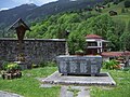
- The miners' chapel is the oldest church in the Montafon, and the construction of the church is first mentioned in a document from 1450. This late Gothic building was built in 1507 by Kasper Schop . At that time miners were buried in a tunnel. Under the rubble, those buried promised to build a church in honor of Saint Agatha . The rescue was successful and the miners kept their promise. The wooden door frames with incised "house signs" from residents from a time when very few could read and write and thus identify their tools and property are unusual. Through a door vaulted by strong masonry, one enters the small vestibule, which is built on the west side to protect against wind and weather. As is customary in churches of this age and this area, the nave has no windows on the north and west sides. The old wooden ceiling, which is decorated with tracery-like ornamented ribbons, is also remarkable. The high altar is a splendid baroque work with its sinuous columns, its ornamental gables and its rich structure.
- Wildried high moor: With a location at about 1540 m above sea level. A. This moor east of the Kristberg is the highest in Europe. It can be reached in about an hour's walk from the mountain station of the Kristbergbahn, or by bike on a forest road with great views. In winter this road is prepared as a cross-country ski run and winter hiking trail.
The municipal office with the Montafon mining museum in Silbertal

Parish church Silbertal with the Kristberg in the background

The Mother of God Altar , one of the two side altars in the parish church
The Silbertal war memorial removed in 2009
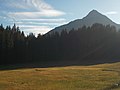
Wildried high moor with Mittagsjoch (2362 m) in the background

Silbertaler Lobspitze (2605 m) from the northwest, seen from Muttjöchle (2074 m).


- Silbertal mining museum
The Montafon Mining Museum Silbertal is a museum that documents the mining history of the whole Montafon, in particular the districts on the Kristberg and the Knappgruaba Worms (municipality of Bartholomäberg) .
- Silbertal open-air theater
The open-air theater in Silbertal is one of the largest stages in Europe with a play area of around 20,000 m² and is dedicated to the legends of the cultural heritage.
societies
- In 1949 the winter sports club Silbertal is founded.
- Citizen music Silbertal
- Volunteer fire brigade Silbertal
- In 1983 the soccer club Silbertal was founded.
Sports
The Montafon-Arlberg-Marathon starts in Silbertal with the destination St. Anton am Arlberg . FC Silbertal is currently participating in the Oberland hobby league.
People born or working in Silbertal
- Herwig Erhard, multiple world champion in competitions for forest workers
- The Nazi perpetrator Josef Vallaster was born in Silbertal.
Web links
- Community website
- 80123 - Silbertal. Community data, Statistics Austria .
Individual evidence
- ↑ Vorarlberg Atlas4. Retrieved May 25, 2020 .
- ↑ "The historical mining in the Montafon"; Jochen Hofmann, Christian Wolkersdorfer; citing Niederstätter 2009, page 105
- ^ Statistics Austria, A look at the community of Silbertal, population development. Accessed March 31, 2019 .
- ↑ Ulrich Nachbaur : Capricorn and Stars. Walserism and municipal coat of arms . In: Montfort. Quarterly magazine for the past and present of Vorarlberg . 65th Volume, Volume 1, 2013, pp. 29–66 ( full text as PDF on the Vorarlberger Landesarchiv website).
- ^ Ulrich Nachbaur : On the creation of the Montafon municipal coat of arms from 1927 to 1967 . In: Alois Niederstätter , Ulrich Nachbaur (eds.): 200 years of community organization. Almanac for the Vorarlberg community year 2008 . Bregenz 2009, ISBN 978-3-902622-10-5 , pp. 301–312 ( full text as PDF on the Vorarlberger Landesarchiv website ).
- ↑ loccata MP3 info on the Kristbergsattel
- ↑ Ski areas: New brand "Silvretta Montafon" (November 28, 2008)
- ^ A b Emil Scheibenstock: The St. Agatha miners' chapel on the Kristberg . 2004 ( pdf 506 kB, online presence Panoramagasthof Kristberg kristberg.at)
- ↑ Adolf Zudrell (Ed.): Kristberg - Silbertal. Montafon . Thurnher, Rankweil 1977 ( web link )
- ↑ Altitude measurement function on http://vogis.cnv.at/atlas/init.aspx?karte=adressen_u_ortsplan
- ↑ bog Wildried. Retrieved May 24, 2020 .
- ↑ World Champion Herwig Erhard ( Memento from February 28, 2005 in the Internet Archive )

Bartholomäberg | Blons | Bludenz | Bludesch | Fire | Bürs | Bürserberg | Dalaas | Fontanella | Gaschurn | Innerbraz | Klösterle | Lech | Lorüns | Ludesch | Nenzing | Nüziders | Raggal | St. Anton im Montafon | St. Gallenkirch | St. Gerold | Schruns | Silbertal | Sunday | Stallhr | Thuringia | Thuringian Mountain | Tschagguns | Vandans