Planting tips
| Pflunspitze | ||
|---|---|---|
|
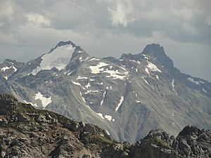
Kaltenberg (left) and Pflunspitze (right) from the north (Roggalspitze) |
||
| height | 2912 m above sea level A. | |
| location | Tyrol and Vorarlberg , Austria | |
| Mountains | Verwall group | |
| Dominance | 5.6 km → Patteriol | |
| Notch height | 974 m ↓ Silbertaler Winterjöchle | |
| Coordinates | 47 ° 4 '46 " N , 10 ° 7' 58" E | |
|
|
||
The Pflunspitzen form with a height of 2912 m above sea level. A. the highest mountain range in the western part of the Verwall group in Austria . They are adjacent to the Kaltenberg ; the closest valley town is Klösterle am Arlberg in the north of the peaks.
The state border Vorarlberg - Tyrol is drawn (running roughly from north to south) over the Pflunspitzen (and further over the ridge to the Kaltenberg). The municipal boundaries of Klösterle, Silbertal and St. Anton am Arlberg meet on the southern Pflunspitze .
The summit structure is divided into the southern Pflunspitze ( 2869 m ), the southern summit, the pre-summit, the main summit ( 2912 m ) and the northern summit. Several routes lead from the Neue Reutlinger Hütte and the Konstanzer Hütte to the summit. The easiest route - degree of difficulty I - leads from the Reutlinger Hütte over the Südscharte to the south summit. Other routes move between the III. and V. Difficulty level and are usually described as beautiful rock climbing, as is the transition from the northern summit to the Kaltenberg (III). The "Via Katrin" (III to VI) leads through the west wall to the main summit.
view
Thanks to their height, the Pflunspitzen offer a wide view. In the south-west, north-west and north-east sector (with the exception of the Schesaplana ) there is no mountain within tens of kilometers higher than the Pflunspitzen. With good visibility, the view extends to the cathedral , 206 km away , to the Bernese Alps ( Nesthorn , Aletschhorn ) and to the Feldberg . To the east, the 3,000-meter peaks of the Tyrolean part of the Verwall partially block the view, but still allow a view of the Ötztal Alps. In the southeast the mighty white massif of the Ortler and its satellite rises prominently . The Silvretta blocks the view to the south somewhat, but it still allows views to the main Alpine ridge (e.g. to the Bernina group ). To the southwest the view is clear again and extends, for example, to Pizzo Tambo on the Swiss-Italian border, or to the Rheinwaldhorn, which is over 100 km away .
View from the Neue Reutlinger Hütte to the west face of the Pflunspitzen
literature
- Peter Pindur, Roland Luzian, Andreas Weiskopf: Alpine Club Leader Verwall Group . Bergverlag Rother , 10th edition, 2005, ISBN 3-7633-1251-X
Individual evidence
- ↑ Eberhard Jurgalski : Complete table of summits in the Alps separated by 590 meters of re-ascent , December 12, 2008. Height of the reference chart according to: Peter Pindur, Roland Luzian, Andreas Weiskopf: Alpenvereinsführer Verwallgruppe, Munich 2005, RZ 226.
- ↑ Federal Office for Metrology and Surveying Austria: Pflunspitze on the Austrian Map online (Austrian map 1: 50,000) .
- ↑ Digital Vorarlberg regional map (map basis: ÖK), see: http://vogis.cnv.at/atlas/init.aspx?karte=adressen_u_ortsplan
- ↑ PeakFinder Ltd [email protected]: 360 ° mountain panorama. Retrieved November 1, 2019 .


