Kristberg
| Innerkristberg ( Scattered Houses ) | ||
|---|---|---|
|
|
||
| Basic data | ||
| Pole. District , state | Bludenz (BL), Vorarlberg | |
| Judicial district | Bludenz | |
| Pole. local community | Silbertal ( KG Silbertal) | |
| Locality | Silbertal | |
| Coordinates | 47 ° 6 '29 " N , 9 ° 58' 57" E | |
| height | 1400 m above sea level A. | |
| Post Code | 6782 | |
| Statistical identification | ||
| Counting district / district | Silbertal (80 123 000) | |
 Houses on the Kristberg plot |
||
| Source: STAT : index of places ; BEV : GEONAM ; VoGIS | ||
| Outside Christ Mountain ( Scattered Houses ) | |
|---|---|
| Basic data | |
| Pole. District , state | Bludenz (BL), Vorarlberg |
| Judicial district | Bludenz |
| Pole. local community | Silbertal ( KG Silbertal) |
| Locality | Silbertal |
| Coordinates | 47 ° 6 ′ 15 ″ N , 9 ° 58 ′ 25 ″ E |
| height | 1190 m above sea level A. |
| Post Code | 6780 |
| Statistical identification | |
| Counting district / district | Silbertal (80 123 000) |
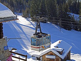
 Mountain station of the Kristbergbahn |
|
| Source: STAT : index of places ; BEV : GEONAM ; VoGIS | |
Kristberg is a place in the Montafon in Vorarlberg , and part of the Silbertal municipality in the Bludenz district .
geography
The place is above the municipal capital Silbertal, on the ridge between Itonskopf and Muttjöchle ( Eisentaler group of Verwall), the northwestern branch of the Verwall group , which separates the Montafoner Silbertal from the Klostertal in the north.
The Steusiedlung is made up of the localities Außenerkristberg and Innerkristberg :
- Innerkristberg is the name of the scattered houses directly below the Kristbergsattel , which leads from Silbertal to Dalaas , and is spread over heights of 1400 m .
- The scattered houses down the valley are called outside of Christberg , they stretch around 1200 m .
Neighboring places:
| Dalaas (gem.) | ||
| Innerberg (Gem. Bartholomäberg ) |

|
|
| Silbertal- Ausser Valley | Silbertal -Innertal | Book |
| Kristbergsattel | ||
|---|---|---|
| Compass direction | south | north |
| Pass height | 1481 m above sea level A. | |
| region | Montafon , Vorarlberg , Austria | Klostertal , Vorarlberg, Austria |
| Watershed | Litzbach , Ill | Alfenz , Ill |
| Valley locations | Silbertal | Dalaas |
| expansion | Municipal road / forest road | |
| Built | Mule track of mining | |
| Mountains | Verwall group | |
| particularities | ||
| profile | ||
| Ø pitch | 32.9% (592 m / 1.8 km) | 33.1% (646 m / 1.95 km) |
| Coordinates | 47 ° 6 ′ 33 ″ N , 9 ° 59 ′ 2 ″ E | |
History and geology
The entire Silbertal- Bartholomäberg area is a mining area for copper and silver that goes back to prehistoric times and experienced its last heyday in the High Middle Ages.
From 1300 to 1320 Walser settled the Silbertal. On the Kristberg, as in the entire Silbertal-Bartholomäberg region, mining has been practiced since prehistoric times, which flourished in the High Middle Ages.
Transport, sightseeing and tourism
Only smaller local roads lead up from the valley and the neighboring villages, otherwise the village can be reached by the Kristbergbahn from Innertal. This cable car belongs to a small skiing and cross-country skiing area, but apart from the overhaul, it is in operation all year round. Driving up the Kristberg in a private vehicle is only permitted with a permit.
The entire ridge is also extensive mountain bike terrain, as there are still numerous old high-altitude trails up to Bludenz, in the inner Silver and Gaflunatal and on the Klostertal side to the valley of the Nenzingastbach and into the Arlberg area . One of them moves east from the mountain station of the Kristbergbahn to the Lobsteg in Wasserstubental, touching the Wildried high moor . In winter it is prepared as a cross-country ski run and winter hiking trail. Over the Kristbergsattel ( 1481 m above sea level ), an old mule crossing to Dalaas, there is only one hiking trail or a forest road that goes down through the Dalaas community forest. From Kristberg there are also climbs to the Itonskopf ( 2089 m above sea level ) and the Muttjöchle ( 2074 m above sea level ). For the latter, a drag lift shortens the ascent in winter, while a rolled track leads from the summit down to the Sonnenkopf ski area in the ski season .
The late Gothic mining chapel of St. Agatha ( Kristbergkirche ) was first documented in 1450 and the construction is assumed to be around 1400.
The mining museum Silbertal down in the valley and the historical mine Bartholomäberg (St. Anna Stollen) near Worms are also interesting for mining in the region .
Web links
- Kristbergbahn website - with pages about the culture of the area
Individual evidence
- 41304 - Silbertal. Community data, Statistics Austria .
- ↑ as the crow flies
