
Sonnenkopf (Vorarlberg)

| Sun head | |
| Number of slopes | 20th |
| Km of slopes (prepared) | 29.5 km |
| light | 12.8 km |
| medium | 15.9 km |
| heavy | 0.8 km |
| unprepared terrain variants | 4 km |
| Fun parks | No |
| halfpipe | No |
| Cross-country trails | 0.2 km |
| Toboggan run | Sonnenkopf mountain station - Sonnenkopf middle station |
| Snow cannons | No |
| Lift systems | 9 |
| Cable cars | 1 |
| Chairlifts | 4th |
| Drag lifts | 3 |
| Rope lifts | 1 |
Sonnenkopf is a ski area in Vorarlberg . It is named after the 2273 m above sea level. A. high Sonnenkopf, an elevation in the Glattingrat, which borders the area in the east . It is located near the municipality of Dalaas in Klostertal , with the mountain station of the Sonnenkopfbahn in the municipality of Silbertal . The valley station is in Klösterle . The ski area is part of the Ski Arlberg tariff association , but there is no lift connection with the main area.
In summer the Sonnenkopfbahn can be used with the Montafon season ticket.
The valley station is served by bus line 90 Bludenz - Stuben in winter.
Natural snow
The Sonnenkopf is one of the few ski areas in Austria that has not yet used snow cannons . The operators also advertise that only natural snow is driven on. The valley run to Wald is laid out on a shady northern slope.
Slopes and lifts
The western part of the ski area consists almost exclusively of blue (easy) slopes, while the eastern part consists almost exclusively of red (medium-difficult) slopes. There is only one black (difficult) slope in the entire ski area, but it is one of the steepest in Vorarlberg.
A gondola lift (8-person single cable gondola lift Sonnenkopf) leads from the valley station in Wald to the ski area. A special feature of this gondola lift is the one-sided middle station, which can only be boarded in the gondolas going uphill. This lift is also in operation in summer. In the main ski area there are four chairlifts and three drag lifts , which are located in flatter areas. The Schneemannland, a ski facility especially for children, is located near the mountain station of the gondola lift . The mountain station of the Glattingratbahn is near the eponymous Sonnenkopf.
A rolled winter hiking trail leads west to Muttjöchle (2074 m). If the snow conditions allow , you can descend or ski down to the Kristbergsattel from there .

View from Muttjöchle: Burtschakopf (dark) to the left of the center, Sonnenkopf to the left above the avalanche barriers, ant tip to the right above, Wasserstubental partly in the shade.
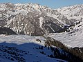
Mountain station of the Sonnenkopfbahn above the Klostertal, Lechquellen Mountains on the other side of the valley, the Lechtal Alps on the right behind .


List of facilities on the Sonnenkopf
| place | Surname | Construction year | system | Height above sea level Valley station [meters] |
Height above sea level Intermediate station [meter] |
Height above sea level Mountain station [meters] |
Track length [meters] |
Transport capacity [pers./hour] |
Operation winter |
Operation summer |
|---|---|---|---|---|---|---|---|---|---|---|
| Kloesterle | Fuchsloch lift |
- | Knitting lift | - | no stopover | - | - | - | W. | 0 |
| Silbertal | Beggar-Älpele-Lift |
- | 2-SL | 1,835 | no stopover | 1,867 | 126 | 1,255 | W. | 0 |
| Silbertal | Glattingratbahn |
1982 | 2-CLF | 2,078 | no stopover | 2,296 | 735 | 1,462 | W. | 0 |
| Valley station: Klösterle
Mountain station: Silbertal |
Obermoosbahn |
1988 | 2-CLF | 1,596 | no stopover | 2,100 | 1.311 | 1,438 | W. | 0 |
| Silbertal | Obermuribahn |
1997 | 4-CLD | 1,832 | no stopover | 2,179 | 1,465 | 2,400 | W. | 0 |
| Silbertal | Riedboden lift |
1975 | 2-SL | 1,790 | no stopover | 1,840 | 544 | 1,060 | W. | 0 |
| Silbertal | Riedkopfbahn |
2011 | 4-CLF | 1,788 | no stopover | 1.952 | 717 | 1,974 | W. | 0 |
| Silbertal | Saddle head lift |
1975 | 2-SL | 1,831 | no stopover | 1,862 | 188 | 1,172 | W. | 0 |
| Valley station: Klösterle
Mountain station: Silbertal |
Sonnenkopfbahn |
1997 | 8-MGD | 1,001 | 1,580 | 1,840 | 2,087 | 2,000 | W. | S. |
| Silbertal | Obermuri connection lift |
- | Knitting lift | - | no stopover | - | 100 | 500 | W. | 0 |
The abbreviations in the "System" column are explained under aerial cableway .
Last 2 columns:
W = winter operation / S = summer operation; green background
0 = no summer operation, red background
Web links
Coordinates: 47 ° 6 ′ 32 ″ N , 10 ° 3 ′ 23 ″ E
Individual evidence
- ↑ Hiking map 032 "Montafon" 1:25 000, edition 2008, publisher: Kompass-Karten GmbH, 6020 Innsbruck-Rum
- ↑ Peter Pindur, Roland Luzian, Andreas Weiskopf: Alpenvereinsführer Verwallgruppe , Bergverlag Rother , 10th edition, 2005, ISBN 3-7633-1251-X , p. 96
- ↑ Vorarlberg Atlas4. Retrieved June 28, 2020 .
- ↑ Season ticket summer 2020 | montafon.at. Retrieved June 28, 2020 .