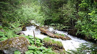
Rellsbach
| Rellsbach | ||
|
The Rellsbach in the Rellstal |
||
| Data | ||
| Water code | AT : 812228 | |
| location | Vorarlberg , Austria | |
| River system | Rhine | |
| Drain over | Ill → Rhine → North Sea | |
| origin | The confluence of the Zaluandabach and Lünbach in the Rellstal valley 47 ° 4 ′ 31 ″ N , 9 ° 52 ′ 21 ″ E |
|
| Source height | 1457 m above sea level A. | |
| muzzle | at Vandans in the Ill coordinates: 47 ° 5 '38 " N , 9 ° 52' 21" E 47 ° 5 '38 " N , 9 ° 52' 21" E |
|
| Mouth height | 631 m above sea level A. | |
| Height difference | 826 m | |
| Bottom slope | 13% | |
| length | 6.6 km | |
The Rellsbach is a largely aligned from east to west watercourses , which the Rellstal flows through and predominantly only the municipality of Vandans crosses and (in the waters kilometers 36.41 Ill ) in the municipality of Bartholomäberg in the Ill opens. In the settlement area of the municipality of Vandans, the Rellsbach flows about 1.5 km.
Location, geography
The creek begins at the confluence of the Zaluandabach and the left-hand Lünbach (Vilifaubach) at water kilometers 6.55 (GwKm) ( 1457 m above sea level ) near the Rellser Mariahilfkapelle ; its watercourse kilometrage continues that of the more important right upper reaches Zaluandabach, which comes here from the south. The Zaluandabach rises at GwKm 12.54 near the Swiss gate (on Vandanser municipality area) in about 2193 m above sea level. A.
In June 1910 the village of Vandans was hit by a devastating flood of the century and was so badly affected by the raging of the Auenlatschbach and the Rellbach that the fertile valley floors were graveled and unusable for agriculture.
The Rellsbach is largely not bordered by dams , but there are very many bed load barriers along its course. Direct access is usually difficult because the Rellsbach flows through a steep ravine . The Rellstalstraße runs with many bends from about 1.40 meters above sea level for about 5 km to the confluence at the Rellstalkapelle (6.55 meters above sea level , 1462 m above sea level ) relatively parallel to the Rellsbach, but at very different elevations, which makes the Rellsbach good can be viewed. The Rellsbach was straightened in the area of the settlement area of the municipality of Vandans .
Tributaries
Significant tributaries of the Rellsbach are (seen from the origin) up to the confluence with the Ill near the municipality of Bartholomäberg at river kilometer 36.41 (Ill):
- at GwKm 5.59 the Sacktobelbach (l);
- at GwKm 5.48 the Kessitobelbach (l);
- at GwKm 5.42 the Mosttobelbach (l);
- at GwKm 5.38 the Kogatobelbach (l);
- at GwKm 5.12 the Brantawittobelbach (r);
- at GwKm 4.74 the stream called Schlittkuchatobel (l);
- at GwKm 4.47 the Tüftobelbach (r);
- at GwKm 4.31 a stream without a name (r);
- at GwKm 4,11 the Marktobelbach (l);
- Gafaduratobelbach (r) at GwKm 3.78;
- at GwKm 3.64 the Bach called Langa Zug (l);
- at GwKm 3.37 the Golmerbach (r);
- at GwKm 3.12 the Brunnentobelbach (r);
- at GwKm 3.09 the Grubsertobelbach (r);
- at GwKm 2.75 the Bach designated as Inneres Ganttobel (l);
- at GwKm 2.65, the Bach designated as the outer Ganttobel (l);
- at GwKm 2.32 the Bach designated as Ganttobel (l);
- at GwKm 2.25 , Bach (r) called Banellatobel ;
- at GwKm 2.10 the Bach (r) called Garsillatobel ;
- at GwKm 0.56 the Sponagraben (r);
- at GwKm 0.27, the last tributary of the Aualatschbach flows into the Rellsbach from the right. A few other, smaller tributaries are known.
Economic use
The lower part of the Rellsbach has been used economically for decades by Vorarlberger Illwerke (since 2019 illwerke vkw ) for the Latschau reservoir ( 992 m above sea level ) and part of the water is diverted.
Effects of the new power plant construction
The new power plant in Rellstal ( Rellswerk ) will change the existing ecosystem. The 22.9 million m 3 of water per year available to date in the upper part of the Rellsbach will be reduced to a doping water output of 72 l / s. This means about 5.9 million m 3 of water per year, which remain in the Rellsbach as doping water or as overflow. "For the existing Rellsbach catchment (lower part of the Rellsbach) this means that instead of the current 27.5 million m 3 / year only 10.5 million m 3 / year (around 38%) can be drawn in." Due to the extensive derivation of the water already in the upper Rellsbach, the previous management of the lower part of the Rellsbach for the Latschau reservoir can no longer be maintained at the previous level.
Web links
Individual evidence
- ↑ In the municipality of Bartholomähberg, the Rellsbach only flows the last few meters of its course.
- ↑ (r) = inflow towards the mouth on the right side of the Rellsbach; (l) = inflow towards the mouth on the left side of the Rellsbach.
- ↑ ENVIRONMENTAL COMPATIBILITY TEST Rellswerk Vorarlberger Illwerke AG , p. 44.
- ↑ ENVIRONMENTAL COMPATIBILITY TEST Rellswerk Vorarlberger Illwerke AG , p. 81.

