
Klostertal (Silvretta)
| Klostertalbach | ||
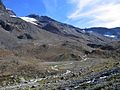
 Klostertaler Bach with Sonntagspitze |
||
| Data | ||
| Water code | AT : 812286 | |
| location | Vermunt , Montafon , Vorarlberg ; Silvretta group | |
| River system | Rhine | |
| Drain over | Silvrettasee → Ill → Rhine → North Sea | |
| source | at the Klostertal Glacier 46 ° 51 ′ 52 ″ N , 10 ° 3 ′ 48 ″ E |
|
| Source height | 2590 m above sea level A. (cartographic) | |
| muzzle | in the Silvrettasee coordinates: 46 ° 53 '59 " N , 10 ° 5' 11" E 46 ° 53 '59 " N , 10 ° 5' 11" E |
|
| Mouth height | 2028 m above sea level A. (cartographic) | |
| Height difference | 562 m
|
|
| Left tributaries | Verhupftälibach | |
| Communities | Gaschurn | |
The Klostertal is a small mountain valley in the Silvretta group , south of the Silvretta reservoir and the Bieler Höhe , the Klostertaler Bach flows through this valley.
Location and landscape
The Klostertal is a side valley of the Ochsental , which represents the source of the Ill . It stretches from the end of the Silvretta lake to the southwest, towards the Großer Litzner ( 3109 m above sea level ), and then to the south towards the glacier ridge of the Silvrettahorn ( 3244 m above sea level ). The valley separates the Seehorn ridge from the north ridge (Egghörner – Schattspitzen ridge) of the Silvrettahorn group , and thus the Middle Silvretta from the Westsilvretta.
This is where the Klostertal Glacier is located , which is the headwaters of the Klostertalbach. Where the brook originates in the cartography, there is only a remains of glacier separated from the shrinking main mass. 300 meters to the east there is a small glacier end lake , further west above the steep step, towards Tälihorn ( 2844 m above sea level ) and Klostertalerspitze ( 2842 m above sea level ), at the old Zollhütte ( 2623 m above sea level ), there are still four small lakes.
The stream then takes on the drainage channel of the other tongues of the Klostertaler glacier, passes between Sonntagspitze ( 2882 m above sea level , in the west, with the Schwarzer Wand ) and Klostertaler Egghorn ( 3120 m above sea level ) in the east.
Below the Klostertaler hut ( 2366 m above sea level. A. ) comes from the left of the Verhupftälibach from Glottergletscher at Winterberg ( 2924 m above sea level. A. ) and gross litzner. A few more nameless streams follow from both sides (and in the high valleys several glacier remnants and cirque lakes ) before it flows into the Silvrettasee.
The entire Klostertal - and the eastern slope on the Silvrettasee up to the Bielerhöhe, at the Lobspitzen Hintere Lobspitze ( 2873 m above sea level ) - is recorded in the Vorarlberg biotope inventory as the Klostertal ( No. 11023 ) large-scale biotope with 1287.13 hectares . According to the author of the Gaschurn inventory, Markus Staudinger, it is “an original and largely natural habitat for the high alpine fauna, including the most important habitat of the reintroduced ibex in the Vorarlberg Silvretta” - alongside the smaller herd of the Vallüla valleys .
The furthest valley is remarkable with its pioneering societies on the large moraine areas . In the rubble of the summit corridors found - else in Verwall and Silvretta missing - Androsace alpina hallway with the eponymous species, the Androsace alpina ( Androsace alpina ). Furthermore come chamois , ptarmigan and marmot frequently Schneehase sporadically.
Paths and huts
In the valley lies the Klostertaler Umwelthütte , which can be easily reached from the Bielerhöhe along the lake and the Klostertalerbach.
From there, paths to the most important peaks are signposted, including crossings into the neighboring valleys:
- Via Verhupf - Litznersattel ( 2737 m above sea level ) - Litzner Glacier - Saarbrücker Hut in the Schweizervermunt in the west
- Via Black Wall - Klosterpass ( 2751 m above sea level ) - Obersilvretta - Sardascla in the southwest
- via Klostertaler Gletscher (or Schwarze Wand - Zollhütte) - Rote Furka - Silvrettahütte in the south into Sardascla
- out of the valley and into the Ochsental in the east to the Wiesbadener hut
photos
Rear Klostertal with Klostertaler Glacier

Middle Klostertal with Klostertaler Umwelthütte

Waterfall to the mouth

muzzle


literature
- Markus Staudinger, AVL Arge Vegetation Ecology and Landscape Planning: Gaschurn . Community report. In: Georg Grabherr; Vorarlberg Landscape Conservation Fund; Vorarlberger Landesregierung - Department of Environmental Protection IVe (Ed.): Biotopinventar Vorarlberg . Vorarlberger Verlagsanstalt, Bregenz June 2008, Alpine large-scale biotope of the Klostertal (Biotope 11023) , p. 42 ( vorarlberg.at [PDF] 1st image: Partial inventory of Montafon, 1984). and the greater Klostertal biotope. on vogis.cnv.at
Web links
Individual evidence
- ↑ a b Cartographic source point according to VOGIS / HAÖ. Due to the retreat of the glacier, the source lies at 2605 m according to an aerial photo in 2009 , and today it is probably further into the valley
- ↑ a b Cartographic point according to VOGIS / HAÖ. The place fluctuates according to the water level of the lake. The hydrographic confluence point (straight connection) is on the lake . According to the f & b tourist hiking map, sheet 37 Rhätikon – Silvrettagruppe from around 1950, which shows the Silvrettasee before its expansion, the drunk estuary is around 2025 m
- ^ Lit. Markus Staudinger: Gaschurn . In: Vorarlberg biotope inventory . 2008, p. 42 .