Villgraten mountains
| Villgraten mountains | |
|---|---|
|
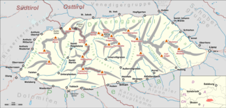
Overview map of the Villgraten mountains |
|
| Highest peak | White peak ( 2962 m above sea level ) |
| location | East Tyrol , South Tyrol |
| part of | Hohe Tauern |
| Classification according to | AVE 38 |
| Coordinates | 46 ° 52 ′ N , 12 ° 21 ′ E |
The Villgratner Berge , also Defregger Gebirge or Deferegger Alpen , are a mountain group of the central Eastern Alps . Together with the Ankogel Group , the Goldberg Group , the Glockner Group , the Schober Group , the Kreuzeck Group , the Granatspitz Group , the Venediger Group and the Rieserferner Group , the Villgraten Mountains form the large group of the Hohe Tauern . The highest peak in the mountain range is the White Peak with a height of 2962 m above sea level A.
location
About two thirds of the area of the Villgraten Mountains is in Austria in the state of Tyrol and one third in Italy in the province of South Tyrol . The mountain group lies in the south of the Hohe Tauern. Lienz , the district capital of East Tyrol , is located on the east side of the mountains. Olang in Pustertal is on the west side. It is named after the Villgratental , which leads into the group from the south.
The Villgraten Mountains are a quiet group of mountains in every respect. There is a lack of spectacular mountain destinations as well as an excessive development with cable cars and roads. The mountain hiker and nature lover, on the other hand, can still find peace and nature in these mountains. The mountains are famous for a multitude of picturesque mountain lakes, their diverse flora and the relatively intact alpine meadows. In particular, the eponymous Villgratental and the neighboring Gsieser Tal valley to the west are considered a ski touring paradise in winter.
Concept history and naming
Mountain range
The mountain group in its current boundaries was introduced in 1845 by Adolf Schaubach in his standard work The German Alps as a southern subgroup of the group Riesenfernergruppe and Tefferecker Gebirge . In addition to the Teffereck Mountains , this group also included the Riesenferner Group ( Rieserferner Group ) and the Virgerner Mountains ( Lasörling Group and Panargenkamm ). The naming was criticized in 1887 by August Böhm von Böhmersheim in its important division of the Eastern Alps and replaced by Villgrattener Gebirge . Since the Villgratental is completely and centrally located within the Villgraten Mountains, while the Defereggental is only on the northern edge of the mountain range, the Schaubach name after von Böhm is not recommended. The renaming quickly established itself in alpine literature. Ludwig Purtscheller consciously chose this name in the first guide for the Villgraten Mountains published in 1897 and granted the name Deferegger Mountains only less justification.
As part of the annexation of South Tyrol , the western part of the Villgraten Mountains was politically part of Italy and officially renamed Monti di Casies after the First World War . But this is not an established field name, but a translation by Ettore Tolomei . German-speaking South Tyroleans often use the term Gsieser Berge .
The term Villgraten Mountains is historically and formally correct for the entire mountain range between the Hochstein west of Lienz and the Staller Sattel . On maps, however, the name Defereggengebirge can be found for the eastern part belonging to Austria as well as the name Gsieser Berge / Monti di Casies for the western part belonging to Italy.
Highest peak
In the center of the group there are two peaks of almost the same height ( ⊙ and ⊙ ), called the White Point and the Red Point . The more easterly with a height of 2962 m above sea level. A. is the highest point in the group. Maps and literature agree on this. However, the assignment of the names to the two peaks is controversial. While most of the alpine literature, the official maps and the inhabitants of the Villgratental south of the mountain range refer to the eastern, higher summit as the White Point and the western, lower neighboring summit as the Red Point , the name comes from the Defreggental north of the group and in a hiking book exactly the other way round, there the highest point is called Rote Spitze .
Since there is no clear name assignment from the sources, the representation of the Federal Office for Metrology and Surveying is given preference. Thus, for the purpose of uniform definition, the eastern, higher summit is the White Point .
summit
No summit of the Villgraten mountains reaches the 3000 meter mark, but 20 peaks are higher than 2800 m above sea level. A. They are (sorted by height):
|
|
The easy-to-climb Toblacher Pfannhorn , 2,663 m above sea level, is also a worthwhile mountain destination . A. dar.
Valleys
Four larger valleys lead from the south into the Villgraten Mountains: the uninhabited Wilfernertal, which flows into the Thal district of Assling , the also uninhabited Kristeinertal, the Villgratental with the communities of Ausser and Innervillgraten and the Gsieser Valley, which is already part of South Tyrol, with the villages of Pichl , St. Magdalena and St. Martin. The Villgraten mountains are bordered in the north by the Defereggental , in the east by the Iseltal , in the southeast by the Lienzer Talboden, in the south by the Pustertal and in the west by the Antholzer Tal . The Staller Saddle forms the border to the Rieserferner Group . Particularly noteworthy within the Villgraten Mountains is the Gsieser Törl as the transition from the South Tyrolean Gsieser Valley to the East Tyrolean Defereggental, which was used as a smuggler's route between Austria and Italy from the First World War until the 1970s .
Neighboring mountain groups
The Villgraten Mountains border the following other mountain groups in the Alps:
- Venediger Group (with the Panargenkamm and Lasörling Group subgroups ) (in the north)
- Garnet Point Group (in the northeast)
- Schobergruppe (in the east)
- Gailtal Alps (in the southeast)
- Carnic main ridge (in the south)
- Dolomites (in the southwest)
- Rieserferner Group (in the northwest)
Huts
In the Villgraten mountains there is a hut of the Alpine Club as well as several private huts and snack stations:
- Hochsteinhütte (ÖAV section Lienz): Altitude: 2023 m above sea level. A. , managed from the beginning of May to the end of October and from December to mid-March, 12 beds, 8 mattress dormitories, valley location: Lienz, walking time from the end of the toll road: 10 minutes
- Gölbnerblickhütte (private): Altitude: 1824 m above sea level. A. , managed from the beginning of June to the end of September, 4 beds, valley location: Anras, walking time from the parking lot in Kristeinertal: 20 minutes
- Volkzeinerhütte (private, formerly called Sillianer Hütte ÖAV section Sillian): Altitude: 1886 m above sea level. A. , managed from around Pentecost to mid-October, 30 beds, 10 mattress dormitories, valley location: Ausservillgraten, walking time from the parking lot in the Winkeltal: 5 minutes
- Unterstalleralm (private): Altitude: 1664 m above sea level. A. , open from mid-May to mid-October, only snack station. Rooms can be rented in the surrounding alpine huts, valley location: Innervillgraten, directly at the car park in the Arntal
- Limestone snack bar (private): Altitude: 1641 m above sea level. A. , managed in the summer and winter seasons, overnight accommodation in the Bad Kalkstein inn or in the Bethanien house of the Kalasantine order , valley location: Kalkstein, directly at the car park.
- Thurntalerrast (private): Altitude: 1978 m above sea level A. , managed from mid-December to Easter and from mid-June to mid-October, 5 holiday apartments, valley location: Auservillgraten, directly accessible via the Unterwalden fraction
- Bonner Hütte (private, former DAV section Bonn): Height: 2340 m above sea level. A. , managed from the end of May to the end of October, 14 beds 11 camps, valley location: Toblach, walking time from Kandellen approx. 2–3 hours
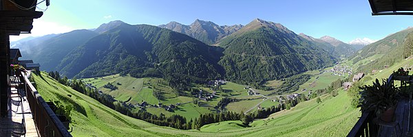
panorama
literature
- Manfred Poleschinski: Villgratner Mountains (Deferegger Alps). Area guide for mountaineers, climbers and hikers. 1st edition, self-published, April 27, 2011; last update: January 31, 2016, pdf , stadtbuecherei-lienz.at; accessed March 11, 2017.
Web links
- Villgraten mountains. summitpost.org (English)
Individual evidence
- ^ Adolf Schaubach: The German Alps , Volume I, Jena 1845, pp. 64–65.
- ↑ August von Böhm : Classification of the Eastern Alps . In: Albrecht Penck (Hrsg.): Geographische Abhandlungen . tape 1 . Eduard Hölzel, Vienna 1887, p. 385 .
- ↑ Ludwig Purtscheller : From the Alpine rim of the Defereggerthales . In: Journal of the German and Austrian Alpine Association , 1897, pp. 155–187.
- ↑ z. B. Walter Mair: Osttirol Süd, Rother hiking guide . 2006, ISBN 3-7633-4132-3 ( limited preview in Google Book Search [accessed April 30, 2011]).
- ↑ a b ÖK50
- ^ Julian Pistotnik: The geological structure of Austria . Ed .: Geological Federal Institute Vienna. Springer-Verlag, Vienna, New York 1980, ISBN 3-211-81556-2 , 3.9.2. Defregger Alps, p. 348-350 ( limited preview in Google Book Search [accessed April 30, 2011]).
- ↑ The Villgratental. (PDF; 7.6 MB) (No longer available online.) P. 10 , archived from the original on October 25, 2009 ; Retrieved April 30, 2011 . Info: The archive link was inserted automatically and has not yet been checked. Please check the original and archive link according to the instructions and then remove this notice.
- ↑ Martin Gasser: Defreggental . Guide for hikers and mountaineers. S. 5 ( jagawirt-alpina.at [PDF; accessed April 30, 2011]).
- ↑ "Defereggental" area guide; Guide for hikers and mountaineers, by Martin Gasser, 184 pages, self-published, cf. there page 34 below


