
Lasörling group

The Lasörling group is a subgroup of the Central Alps in the Eastern Alps. The boundaries of the mountain group in East Tyrol essentially form the Virgental in the north and the Defereggental in the south. According to the agreement of the Alpine clubs in 1984 , the Lasörling group is part of the Venediger group and forms its southeastern part. In older divisions of the Eastern Alps, the Lasörling group was still included in the Defereggen Mountains ( Villgratner Mountains ). The highest mountain in the Lasörling group is the eponymous Lasörling ( 3098 m above sea level ). The neighboring Panargen ridge is also partially included in the Lasörling group. The highest mountain is the Lasörling ( 3098 m above sea level ), if the Panargenkamm is included, the Keeseck ( 3173 m above sea level ) is the highest peak.
Municipalities with a share in the Lasörling group are the municipalities of the Virgental ( Matrei in Osttirol , Virgen , Prägraten am Großvenediger ) and the Defereggental ( Hopfgarten , Sankt Veit , Sankt Jakob ).
Summit of the Lasörling group
|
|
|
Refuges
The Neue Reichenberger Hütte is located on the western edge of the Lasörling group and serves as the starting point for tours around the Finsterkarspitze . In the central area there is the privately run Lasörlinghütte , which mountaineers can use to ascent the Lasörling . On the northern edge of the Lasörling group there are several mountain huts and snack stations: Lasnitzenhütte , Bergerseehütte , Arnitzalm and Zunigalm .
photos
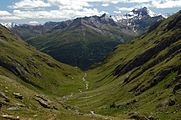
Lasörling group seen from the Eisseehütte or the Timmeltal (on valley axis: Berger Kogel )
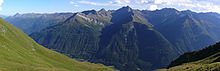
Lasörling Group of the Sajathütte seen from

Bergerseehütte ( 2181 m ) (below the Goldeckscharte ), seen from the ascent to the Berger Kogel (1980)


.jpg)
Individual evidence
Coordinates: 46 ° 58 ' N , 12 ° 21' E