
Carnic Alps
| Carnic Alps | |
|---|---|
| Highest peak | Hohe Warte (Italian Monte Coglians ) ( 2780 m above sea level ) |
| location |
East Tyrol , Carinthia , South Tyrol , Belluno , Friuli |
| part of | Southern Limestone Alps |
| Coordinates | 46 ° 30 ' N , 13 ° 0' E |
The Carnic Alps are a mountain group of the Southern Limestone Alps . They lie on the border between Austria ( East Tyrol , Carinthia ) and Italy ( South Tyrol , Belluno , Friuli ).
Landscapes and structure
Structure according to AVE
The Carnic Alps are divided into two distinctive sections:
|
Historical concept of the 19th century
The term was used in the 19th century for a tripartite division of the Eastern Alps into Noric Alps, Carnic Alps (A. Carnicae) and Julische (A. Juliae) or Carniolan Alps . These three groups extend over the following mountain groups, as given by the AVE:
- the Juliae from Triglav (old: Terglu ) to the Dinaric Alps ( Dinarides ) - today's term Julian Alps largely corresponds to this
- the Carnicae along the Drau up to the Save (old: Sau) - these are today's Carnic Alps (which are still called the Carnic main ridge afterwards ), the Gailtal Alps , the Karawanken , Steiner Alps ( Kamniške or Savinjske Alpe , Save -Alps') and the Bacher Mountains ( Pohorje )
- and the Noricae the entire area from the Danube to the Drau ( i.e. today's eastern northern and central Alps , with the western border of the eastern Alps being seen at the Dreiherrenspitze at that time). That has hardly anything to do with the current term of the Noric Alps .
Carnic main ridge

The Carnic main ridge forms a strongly pronounced ridge that runs from east to west and is more than 100 km long between the catchment areas of the Drava , Gail and Tagliamento and is a popular hiking area .
The ridge begins in the west with the striking Helm ( 2433 m ) in the Sesto ski area , reaches almost 2,700 meters several times with Pfannspitze ( 2678 m ), Großer Kinigat ( 2689 m ) and Hochweißstein ( Monte Peralba , 2694 m ) and in the Hohe Warte as the highest peak 2780 m .
The eastern, lower part of the mountain range is crossed by two important passes : Plöckenpass and Nassfeldpass .
The Carnic Alps include the Eiskar - embedded in the basement wall massif - the southernmost glacier in Austria.
history
"Carnia" was a region of the Imperium Romanum , the name was probably based on an older Celtic name. The " Carantania " of the Carolingian era was populated by Bavaria as well as by Slavs (Slovenes).
During the First World War , the front between Italy and Austria ran along the Carnic Alps. The traces of this mountain war are still numerous today. In Kötschach-Mauthen there is also a multi-award-winning museum with open-air facilities in the Plöckenpass area (for example at the Kleiner Pal ) and the Peace Paths project launched by Walther Schaumann (1923–2004) around 1970 .
In a 3-year project until 2021, a war museum will be built on the Carnic ridge near Kartitsch.
geology

For the geology , the massive, 1,300 m are mighty coral reefs of Kellerwand- and High Response region in the shortest spatial distance Tiefseekalken around the Wolayersee unique in the world: This Paleozoic limestone massifs are more than 400 million years (from the Carboniferous , Devonian and Silurian ) many times older than the actual Mesozoic Alps themselves and were formed in areas close to the equator, which in the Devonian were still on the northern coast of Africa in the flat and warm sea. The "Geo-Trail" hiking route connects some mountain trails rich in fossils and is the longest geological hiking trail in Europe. The Periadriatic Seam , the geological boundary between the continental plates of Africa and Europe , runs along the northern edge of the mountains in the accompanying Gail Valley . It stretches from Ticino via the Pustertal to the Karawanken .
The Carnic Alps are among the 100 most important geological regions on earth. Nowhere in Europe are the development areas of the deep sea, the continental margins and the reef lagoons of ancient times so close together that you can experience them in the immediate vicinity at a glance (Rauchkofel-Hohe-Warte-Kellerwand-Cellon). The preservation of the fossils is remarkable despite the multiple mountain folding. Geologists from all over the world regularly come to see this phenomenon on site.
The Carnic Alps gave their name to the Carnium , a period of the Upper Triassic .
Refuges


From west to east:
- Hahnspielhütte (Rifugio Gallo Cedrone), 2200 m slm
- Sillianer Hütte , 2380 m above sea level A.
- Obstansersee hut , 2304 m above sea level A.
- Filmoor-Standschützenhütte , 2350 m above sea level A.
- Rifugio Monte Cavallino , 1849 m slm
- Porzehütte , 1930 m above sea level A.
- Mitterkar bivouac , 1973 m above sea level A.
- Armando Piva bivouac , about 2450 m slm
- Hochweißsteinhaus , 1867 m above sea level A.
- Letterspitz bivouac , 2080 m above sea level A.
- Rifugio Pier Fortunato Calvi , 2167 m slm
- Rifugio Monte Ferro , 1563 m asl
- Wolayerseehütte formerly Eduard-Pichl-Hütte , 1967 m above sea level. A.
- Rifugio Lambertenghi e Romanin , 1951 m slm
- Rifugio Giovanni e Olinto Marinelli , 2120 m slm
- Eiskarhüttl (World War Cavern ), about 2100 m above sea level. A.
- Zollnerseehütte formerly Dr.-Steinwender-Hütte , 1720 m above sea level. A.
- Rudnigalm , 1621 m above sea level A.
- Bivacco Ernesto Lomasti , 1920 m slm
- Treßdorfer Alm , 1585 m above sea level. A.
- Nassfeldhaus , 1513 m above sea level A. (has not been an AV hut since 2000)
- Rifugio Fratelli Nordio , 1210 m slm
- Feistritzer Alm , 1718 m above sea level A.
- Achomitzer Alm , also Schönwipfel-Schutzhaus , 1718 m above sea level. A.
photos

Obstanser Sattel (Carnic High Trail)
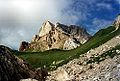
View of the Wolayer Seewarte from a point just before the Wolayersee
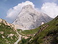
Hochweißstein ( Monte Peralba ) from the northeast

Monte Chiadenis from the north


literature
- Hubert Bergmann, Heinz Dieter Pohl : The names of the Carnic Alps. Part I: Carinthian part (from Steinkarspitz to Plöckenpass). Municipalities of Lesachtal and Kötschach-Mauthen, Carinthia. (= Supplement to Austrian Name Research 2). Present Verlag, Vienna 2002, ISBN 3-7069-0195-1 .
- Gerhard Leeb, Gerhild Gonzalez Guerrero: Mysterious Carnic Alps . Villach 2009, ISBN 978-3-9502379-1-7 .
- Liselotte Buchenauer : Carnic Alps. Leykam, Graz / Vienna 1986, ISBN 3-7011-7168-8 .
- Gabriele and Walther Schaumann : On the way from the Plöckenpass to the Canal Valley. On the trail of the Carnic Front 1915–1917. Verlag Mohorjeva - Hermagoras, Klagenfurt 2004, ISBN 3-7086-0025-8 . (with tour guide)
- Peter Holl: Alpine Club Leader Carnic Main Ridge . Bergverlag Rudolf Rother , Munich 1988, ISBN 3-7633-1254-4 . Alpenvereinsführer Karnischer Hauptkamm in the Google book search
- Lutz Kreutzer : Photo Atlas of the Variscan Carbonate Rocks in the Carnic Alps (Austria / Italy) - Photo Atlas of the Variscan Carbonate Sequences in the Carnic Alps (Austria / Italy) . (= Treatises of the Federal Geological Institute. Volume 47). Verlag der Geologische Bundesanstalt, 1992, ISBN 3-900312-82-6 .
- Peter Kübler, Hugo Reider: War for Sexten • The western Carnic Alps and the Kreuzberg area in the First World War 1915-1918 with tour descriptions for today . Sexten 2017. ISBN 978-3-9816744-2-2 (online [1] )
Web links
- The entire Karnische Höhenweg, KHW 403, pictures, texts and maps
- Carnic high path, pictures
- Carnic Alps - Hribi.net
- Karnische Höhenweg No. 403 (Friedenswege - Le vie della pace; at Dolomitenfreunde , Kötschach - Mauthen)
Individual evidence
- ↑ Alps . In: Heinrich August Pierer , Julius Löbe (Hrsg.): Universal Lexicon of the Present and the Past . 4th edition. tape 1 . Altenburg 1857, p. 349-351 ( zeno.org ).
- ↑ Open-air museum on the Carnic Ridge. In: tirol.orf.at. August 18, 2018, accessed November 13, 2018 .
- ↑ Karnischer Kamm becomes a war museum. In: tt.com. June 21, 2018, accessed March 5, 2020 .
