
Carnic high path
| Carnic high path Via Traversata Carnica |
|
|---|---|
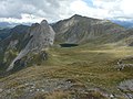
 Val Fleons on the southern slope of the Carnic main ridge |
|
| Data | |
| length | approx. 155 km |
| location | Carinthia , East Tyrol , Veneto , Friuli-Venezia Giulia |
| Type | Long-distance hiking trail |
| season | summer |
| Months | Mid-June to mid-September |
The Carnic High Trail (path no.403) is a hiking trail in the Carnic Alps , which is largely at the height of the Carnic main ridge in several variants along the state border between Italy (regions Veneto and Friuli-Venezia Giulia ) and Austria (federal states Tyrol , more precisely East Tyrol and Carinthia ). It touches nine refuges and has a total length of around 155 km. At the same time, it is part of the Südalpenweg (Austrian long-distance hiking trail 03) and the Friedensweg, the idea of which already existed in the Gruber-De-Gasperi Agreement of 1946. It is also part of the Via Alpina Red Trail . The high path itself does not present any particular difficulties for hikers. However, it must be taken into account that the stages (sometimes up to nine hours) are very long. In the main season July / August the path is very crowded and there may be bottlenecks when staying overnight in the huts. Since most hikers arrive and depart on the weekend, we recommend starting outside the weekends. The path can be walked in both directions; Depending on the direction, the frontal solar radiation dominates in the morning or in the afternoon. If there is an impending sudden fall in the weather, you should not hesitate to use one of the numerous emergency descents into the valley, as there is a high risk of lightning strikes on the exposed mountain path.
history

The Carnic Alps were opened up for tourism from the middle of the 19th century, but the Carnic High Trail owes its existence to the First World War , when the Triple Alliance between Italy, Austria and the German Empire broke and the mountain war in the Carnic Alps began in 1915 . In preparation for this war, supply routes were laid on both sides of the state border, on which gun emplacements , casemates , passages, accommodation and later also cemeteries were built.
As a result of the Second World War , partisan activities began in early 1944 , which severely damaged or destroyed the infrastructure of the region and parts of the route system. Over the decades, other parts of the connecting routes fell into disrepair. In 1970 the mountain rescue doctor Ernst Steinwender and Richard Grumm campaigned for the reconstruction of the path system in order to promote tourism in the area again. In 1974 the paths were restored and connected.
Numerous ruins from the time of the First World War still exist today. In Kötschach-Mauthen there is the museum from 1915 to 1918 from the Ortler to the Adria of the friends of the Dolomites about this mountain war, which was opened in 1992.
particularities
Due to the geological diversity of the rock in the Carnic Alps, a geological nature trail (the Geo-Trail ) was set up between Sillian and the Naßfeld . With the help of display boards along the way, the geology of the Carnic Alps is explained in more detail.
Stages

The Carnic High Trail is usually divided into eight to eleven stages.
1st stage: The Italian starting point of the route is Sexten , Austrian Sillian . From both places you can get to the Helm ( 2434 m ), over the ridge along the Austrian-Italian border in 4 hours to the Sillianer Hütte ( 2447 m ). In Sexten and Obervierschach there are cable cars that shorten the walking time to two and a half hours.
2nd stage: From the Sillianer Hütte to the Obstansersee-Hütte ( 2304 m ) in 5 hours with a few summit crossings ( Hornischegg 2550 m , Hollbrucker Spitze 2581 m , Demut 2592 m and Eisenreich 2665 m ).

3rd stage: From the Obstanserseehütte to the Porzehütte ( 1942 m ) in 7 hours with crossing the Pfannspitze ( 2678 m ), the Große Kinigat ( 2689 m ) with an easy via ferrata , but a southern bypass of the Große Kinigat is possible via a steeply sloping gravel field . Past the small Filmoor Standschützenhütte ( 2350 m , overnight accommodation) through the Rosskar down to the Porzehütte.
4th stage: from the Porzehütte to the Hochweißsteinhaus ( 1868 m ) in 9 hours. The path leads south to the Tilliacher Joch and then exactly on the main ridge over the Reiterkarspitz ( 2422 m ), then on the Winklerjoch south of the main ridge to the Hochspitzsenke ( 2314 m ). The Hochspitz can be bypassed to the north, above the Mitterkar-Biwak bivouac box it goes over the Steinkarspitz ( 2524 m ) to the Luggauer Sattel , then to the northeast down around the Torkarspitz to the hut.
5th stage: from the Hochweißsteinhaus to the Wolayer-See-Hütte ( 1959 m ) or to the Rifugio Lambertenghi Romanin ( 1955 m ) in 6 hours. First up to the Öfnerjoch ( 2011 m ) then down into the wooded southern flank of the main ridge through the Val Fleons , past ancient, partly abandoned Caseras , up to the Giramondo Pass ( 2005 m ). From the pass very steeply down to the upper Wolayeralm , then over a gravel road up to the Birnbaumer Törl with a striking war memorial to the Austrian Wolayer-See-Hütte or 15 minutes further along the west bank of the Wolayer See to the Italian Rifugio Lambertenghi Romanin.

6th stage: from Wolayer See to the Untere Valentinalm ( 1220 m ) in 2 hours. First along the lake to the north of the Hohe Warte (Italian: Monte Coglians , 2780 m ) down to the Valentinstörl , then to the Upper Valentinalm and on to the Lower. The ascent of the Hohe Warte through the north face ( Koban-Prunner-Weg ) requires a whole day and in some places has the UIAA II level of difficulty .
7th stage: From the Lower Valentinalm to the Zollnerseehütte (formerly Dr. Steinwender-Hütte; 1720 m ) in 8 hours. First to the Plöckenpass-Straße ( 1215 m at the Plöckenhaus restaurant). Go south along the street until the “Museumsweg” branches off to the left. Follow this to the small museum for the history of the mountain war 1915–1918 , then via path 401 (museum path) along the former fortifications on the main ridge, then following path 402 to Lago Avostanis ( 1936 m ). Down the road to the south-east until path 448 turns left. Walk this up to Monte Scarniz ( 2118 m ), continue to Hohen Trieb ( 2198 m ), north in easy climbing down to the Kleiner Trieb and then to the Zollnerseehütte.
8th stage: From the Zollnerseehütte to Nassfeld in 8 hours. On the easy path 403 over the Straniger Alm ( 1479 m ), then over the Kordinsattel ( 1752 m ) to the Cima di Lanza ( 1893 m ) on to the Trogkofel ( 2297 m , via ferrata with ladders, equipment required, medium difficulty, not for beginners ), bypass this south. Then to the Rudnigsattel ( 1889 m ), left down to Nassfeld.
Most of the people who walk the trail end it at Nassfeld or before at the Plöckenpass road. However, it is possible to follow its course further to Thörl-Maglern . The path largely loses its alpine character on this section and leads over several alpine pastures and through wooded terrain. Another two to three days are required for this, whereby overnight stays at alpine inns can be used.
photos

Rifugio Pier Fortunato Calvi
The basin of the Obstansersee in the Carnic Alps

The Karnische Höhenweg, near the Porzehütte


literature
- Peter Holl: Alpine Club Leader Carnic Main Ridge. Bergverlag Rother . Munich 1988, ISBN 3-7633-1254-4 .
- Evamaria Wecker: Karnischer Höhenweg , Bergverlag Rother . Munich 2016, ISBN 978-3-7633-4404-8 .
- Ingrid Pilz: Carnic Alps natural paradise. 100 hikes, mountain tours and via ferratas. Styria-Verlag, Graz 1996, ISBN 3-222-12429-9 .
- G. Kleewein: Kompass hiking book Gailtal - Lesachtal - Carnic High Trail. Mair-Verlag, 1999, ISBN 3-85491-500-4 .
- H. Mitterhauser: The Carnic High Trail. Austrian Alpine Club, Vienna 2002
- TVB Hochpustertal: The Carnic High Trail. Released in autumn 2007
- Walther Schaumann : Scenes of the Mountain War III a. Western Carnic Alps. From Sexten to the Plöckenpass , Ghedina & Tassotti, 1984.
- Peter Kübler, Hugo Reider: War for Sexten • The western Carnic Alps and the Kreuzberg area in the First World War 1915-1918 with tour descriptions for today . Sexten 2017. ISBN 978-3-9816744-2-2 (online [1] )
Magazines
- Alpin , issue 6/1989
- Berge , volume 55 "Carnic Alps", 1992
- Bergsteiger , issue 1/2001
cards
- Tobacco hiking maps 1: 25: 000, pages 01, 09, 010, 017, 018
- Austrian map 1: 50: 000, pages 195-199, current UTM version: 3108-3111, 3116, 3117
- Freytag & Berndt , hiking map 1: 50,000, sheets 182 and 223,
- Compass hiking maps 1: 50,000, pages 47, 58, 60
Web links
- The entire Karnische Höhenweg KHW403 from Sillian to Thörl-Maglern
- Link collection and photos
- Carnic High Trail, stages 1 - 3
- Carnic High Trail, stages 1 - 6
Individual evidence
- ↑ Internet page about the way at austria.info , accessed February 12, 2016
- ^ ÖK 50-UTM