
Hochweißsteinhaus
| Hochweißsteinhaus ÖAV refuge, category I |
||
|---|---|---|
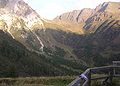
 The Hochweißsteinhaus in the Carnic Alps |
||
| location | Johanniseben; Carinthia | |
| Mountain range | Carnic main ridge | |
| Geographical location: | 46 ° 38 '34.5 " N , 12 ° 44' 25.1" E | |
| Altitude | 1867 m above sea level A. | |
|
||
| owner | Alpine Association Austria of the PES | |
| Built | 1927 | |
| Construction type | Refuge | |
| accommodation | 14 beds, 36 camps | |
| Hut directory | ÖAV DAV | |

The Hochweißsteinhaus is an alpine club hut of the Alpenverein Austria section of the PES , located in the Carnic Alps , which is classified as AV hut category I and is an important stage base on the Carnic High Trail .
location
The Hochweißsteinhaus is located on the Carnic High Trail between Frohnalm and Öfner Joch, as well as below the Hochalpljoch.
history
The Hochweißsteinhaus was built in 1927 by the Austria section of the Austrian Alpine Club. The hut was built at the fork of two former mule tracks that led south across the Carnic Alpine ridge. These used to be very important for the movement of goods to Italy and led down over the passes into the valley of the Piave to the south . The path branching off to the southeast at the location of the Hochweißsteinhaus led over the Öfnerjoch to Forni Avoltri , while the path that bent in a south-westerly direction led up to the Hochalplpass and then descended from there to Sappada / Bladen . Wood that had been felled in the Lesach Valley was sometimes even transported to Venice via these two routes .
The first tenant of the Hochweißsteinhaus was the initiator of the hut construction, Adam Salcher, an innkeeper and mountain guide from the Lesach Valley. During the First World War he had been on duty in the area around the hut in the standschützen line-up. When Italy declared war on Austria in 1915, the Standschützen had occupied the Hochweißstein , just south of the border, before Italian troops could take up position there. Due to its exposed location, this mountain, which was strategically important for both sides in the mountain war of 1915–1918 , was held by the Austrians until the end of the war and was named after the newly built hut twelve years later.
In the years after the Second World War, the hut was badly damaged by looting and was not restored until 1949. In 1972 the Hochweißsteinhaus was again affected by vandalism, which largely destroyed the hut inventory.
Further damage to the hut occurred in 1975, this time, however, not from human impact, but from an avalanche. This was caused by the large amounts of snow in the spring and had caused considerable damage to the hut. The refurbishment of the hut could only be carried out in September, so that summer operation was only possible to a very limited extent that year.
Approaches
- From the northwest
- from Maria Luggau ( 1173 m ) in 5 hours
- from Maria Luggau via the road to the Frohnalm car park ( 1580 m ), from there in three quarters of an hour
- From the north
- from St. Lorenzen in the Lesachtal ( 1127 m ) in 3 hours
- From the northeast
- from Liesing ( 1044 m ) in 5 hours
Tours
The closest huts on the Carnic High Trail are:
- the Wolayerseehütte ( 1960 m ) in 6 hours
- the Porzehütte (1,942 m) in 8 hours
- the Mitterkar bivouac ( 1973 m ) in 4 hours (emergency accommodation)
- the Rif. Calvi ( 2164 m ) via Hochalpljoch and Bladner Joch in 2 hours
- the Filmoor-Standschützenhütte ( 2350 m ) in 10 hours
- the Obstansersee hut (2304 m) in 12 hours
Mountaineering
- Raudenspitze ( 2507 m ) in 3 hours
- Hochweißstein (Monte Peralba) ( 2693 m ) in 3 hours
- Torkarspitze ( 2573 m ) in 3 hours
- Zwölferspitz ( 2593 m ) in 3 hours
- Weißsteinspitze ( 2462 m )
- Hochalpl ( 2345 m )
photos

The Frohntal-Almweg leading towards the Hochweißsteinhaus

The Frohnalm parking lot on the way to the hut

The Ingridhütte located a little below the hut
On the terrace of the Hochweißsteinhaus


