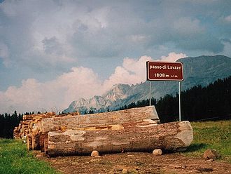
Passo di Lavazè
| Passo di Lavazè | |||
|---|---|---|---|
|
Sign at the top of the pass |
|||
| Compass direction | North | south | |
| Pass height | 1808 m slm | ||
| province | Trent | ||
| Watershed | Eggentaler Bach → Eisack → Etsch | Rio Gambis → Avisio → Etsch | |
| Valley locations | Birchabruck ( Eggental ) | Varena ( Fiemme Valley ) | |
| expansion |
|
||
| Mountains | Fiemme Valley Alps | ||
| Map (Trentino) | |||
|
|
|||
| Coordinates | 46 ° 21 '25 " N , 11 ° 29' 44" E | ||
The Lavazèjoch (also Zanggenjoch , Italian Passo di Lavazè ) is a mountain pass in the Italian province of Trento . It connects the south-facing Val di Gambis , a side valley of the Fiemme Valley , with the north-facing Eggental . The top of the pass reaches a height of 1808 m slm and is around 800 meters south of the border with South Tyrol .
At the top of the pass, a road branches off to the west to the Jochgrimm ( Passo di Oclini ) between Weißhorn and Schwarzhorn . In the east, the Zanggen towers over the yoke.
The top of the pass turns out to be more of a plateau than a pass and is therefore also suitable for cross-country skiing.
Web links
Commons : Passo di Lavazè - Collection of images, videos and audio files

