Weißhorn (Fleimstal Alps)
| Weisshorn | ||
|---|---|---|
|
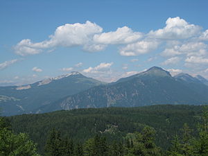
The Weißhorn seen from the west of Radein |
||
| height | 2317 m slm | |
| location | South Tyrol , Italy | |
| Mountains | Fiemme Valley Alps | |
| Dominance | 2 km → Schwarzhorn | |
| Notch height | 328 m ↓ Jochgrimm | |
| Coordinates | 46 ° 21 '17 " N , 11 ° 26' 36" E | |
|
|
||
| Type | Zeugenberg | |
| rock | Dolomite ( sarldolomite ) | |
| Age of the rock | Anisium (Middle Triassic ) | |
| Normal way | easy hike from Jochgrimm or from Aldein or Radein | |
|
White Horn (left) and Black Horn (right) from the southwest to the Monte Corno seen from |
||
The Weißhorn ( Corno Bianco ), sometimes also called Aldeiner Weißhorn to distinguish it from mountains of the same name , is a 2317 m high mountain in the Fiemme Valley Alps in South Tyrol ( Italy ). Together with its neighboring twin mountain , the Schwarzhorn , it is visible from afar due to its isolated location.
Location and surroundings
The Weißhorn is a free-standing mountain south of the Regglberger high plateau, which stretches between the Unterland and Eggental . On its western flank is the beginning of the geologically interesting Bletterbach canyon, in the east the terrain slopes down to the Lavazèjoch , behind which the Zanggen and, further northeast, the Latemar rise. On its south side, the summit is connected via the Jochgrimm ( 1989 m ) with its somewhat higher twin mountain, the Schwarzhorn ( 2439 m ).
Politically, the Weißhorn is located in the area of the municipality of Aldein in the south of South Tyrol.
geology
The summit of the Weißhorn consists of white Sarldolomite . It owes its name to this rock and the color contrast to the neighboring Schwarzhorn, which consists of reddish-gray Bozener quartz porphyry . The geological fault of the so-called Trudner Line runs between the two mountain peaks , along which the Schwarzhorn was raised by more than 1000 m compared to the Weißhorn. The layers above the porphyry were removed by erosion, which means that the two peaks are of similar height today.
Alpinism
The White Horn is accessible from several sides and is regarded as a simple tour goal as despite a steep final climb through the peaks rocks not difficult is classified.
The most popular tour on the Weißhorn begins at Jochgrimm and leads over meadows and through pine fields from the east to the summit structure. Other trails lead from the west (from Radein on the edge of the Bletterbach gorge) and north to the mountain peak, which consists of a short north-south ridge. The summit cross is on its northern edge at 2313 m , but the highest point is at the southern end at 2317 m .
Individual evidence
- ↑ Gerhard Niedermayr: The Bletterbach Gorge near Radein (Redagno) - A hike through 50 million years of geological history. In: Communications from the Austrian Mineralogical Society. Vol. 153, 2007. PDF file
- ↑ Hanspaul Menara : The most beautiful 2000s in South Tyrol . Athesia, Bozen 2012, ISBN 978-88-8266-830-3 , pp. 78-79


