Sella di Camporosso
| Sella di Camporosso, Saifnitz Saddle ( valley watershed ) |
|||
|---|---|---|---|
| Compass direction | west | east | |
| height | 816 m slm | ||
| Canal Valley , Friuli , Italy | |||
| Watershed | Torrente Fella → Fiume Fella → Tagliamento → Adriatic / Mediterranean Sea ( Tagliamento ) | Rio Bartolo → Slizza / Gailitz → Gail → Drau → Danube → Black Sea ( Drau ) | |
| Valley locations | Ugovizza ; Carnia | Tarvisio ; Arnoldstein | |
| expansion | A23 , SS13 | ||
| Built | Altstrasse | ||
| Mountains | Carnic Alps / Julian Alps | ||
| map | |||
|
|
|||
| Coordinates | 46 ° 30 '23 " N , 13 ° 31' 48" E | ||
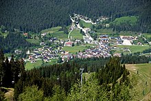
The Sella di Camporosso ( furlanisch Siele di Cjamparòs , German Saifnitzer Sattel , Saifnitzpass or Saifnitzer Wasserscheide , Slovenian Žabnice ) is the 816 m high valley watershed in the Channel Valley near Tarvisio (Tarvis), in the village of Camporosso in Valcanale (German Saifnitz in the Channel Valley ). It connects Carinthia with Friuli-Venezia Giulia . The valley separates the Julian Alps in the south from the Carnic Alps in the northeast.
Location and landscape
The pass is located 26 kilometers southwest of Villach and 50 kilometers northeast of Udine . Arnoldstein is 14 kilometers northeast in the Untergailtal , 4 kilometers east is Tarvisio, 7 kilometers west is Malborghetto .
The Camporosso is not an orographic landmark, but a valley pass that stretches for a good 3 kilometers and drains on both sides. It is a largely flat trough valley and coincides with the local area of Camporosso in Valcanale , a fraction of the municipality of Tarvisio, which stretches along the northern slope as a street village.
History and traffic
The pass forms an ancient, easy transition from the upper Adriatic coast to the inner-alpine basin landscape of the Drautal and the Pannonian region .
The Roman crossing is the Roman road Aquileia - Virunum , here was probably the Statio Bilachiniensis . Today the SS13 Pontebbana state road and the A23 Alpe-Adria motorway are located here , although the latter bypasses the pass in the 1.8 km long Spartiacque tunnel to the south.
In 1879 the Austro-Hungarian State Railway Tarvis - Pontafel (Pontebba) was opened here, which led from the Austrian Rudolfsbahn to the Italian Pontebbana Udine - Pontebba, which was built in 1866, to the then national border, and was collectively referred to as the Pontafelbahn . In 2000, the last section of the New Pontebbana, which began in 1886, was opened here as a 7-kilometer Camporosso tunnel (south, roughly below the middle station of the new gondola lift to Monte Lussari ). The old railway was dismantled, the railway line is still preserved as the municipal road Via Stazione / Feldweg.
Geology, hydrography and hydraulic engineering
The Camporosso Pass forms the Mediterranean – Black Sea watershed : the Fella goes over the Tagliamento to the Adriatic Sea , the Slizza to the Gail , a tributary of the Drava to the Danube . After leaving the main European watershed in western Switzerland, this sheath runs along the main Alpine ridge and then eastwards from South Tyrol along the Carnic main ridge , and bends sharply to the north at the Schönwipfel , from where it goes south-east via Camporosso into the Julier and Dinarides of the Balkan peninsula goes to the Bosphorus .
On both sides of the village, there are huge cones of rubble from the mountain streams across the valley . The eastern one, that of the Fella, is the higher of the two and forms the actual watershed. The bedload can become enormous in the heavy driving rain ( Adriatic lows ) that regularly occurs here , for example a flood of the Rio Lussari in 1896 alone brought more than 20,000 cubic meters into the plateau and relocated the former Reichstrasse. It is reported that in the years 1860–1880, despite all cleaning measures, the route had to be raised an average of 15 cm per year. For the end of the 19th century, the valley entry of the Fella was at least 825 m above sea level. A. Sea level indicated, the plateau with about 810 m above sea level. A.
Waters
The Torrente Fella (Filza) comes from the northwest of the mountain Mirnig ( 1391 m slm ) and Vetta Secca ( 1391 m slm ) into the valley and then flows as Fiume Fella westward through the Val Canale (Canal Valley) and Canal del Ferro ( Iron Valley ) to Tagliamento river .
The Torrente Bartolo (Bartolobach) comes from the north from the Schönwipfel ( 1813 m above sea level ) into the valley, unites with the Rio Lussari (Lussaribach) coming from the south from Monte Santo di Lussari ( 1788 m slm ) and the shorter Torrente Casarenza ( Suchagraben) and then leads east to Slizza / Gailitz and Gail .
In the high valley between Fella and Bartolo lies the drainless wetland Jezera (Slovenian dialectal 'lake'). It has become common practice to locate the top of the pass at this lowest point in the valley.
Casarenza, located between Fella and Bartolo, originally flowed into a saddle wetland without drainage , at 796 m above sea level. A. , and when it rained heavily south of the village it formed a lake, known locally as Jezera , to which the brook was already routed through the village with artificial dams in the 19th century. For example, in March 1872 the lake reached a depth of 8 meters and flooded the lower houses of the village. At about 805 m above sea level. At that time A. was the deepest point of the narrow channel, which allows a certain seepage drainage and the overflow to the Bartolobach. Only when the railway was built in 1877–1879 was the profile there at 801.7 m above sea level. A. deepened, the lake only reached a third of the old area.
Today the Casarenza is fed permanently to the Bartolo via the old railway line, but remained problematic despite all the obstructions. The flood in August 2003 caused extensive damage again, with 1 million euros being spent on the bridges over the stream alone.
Individual evidence
-
↑ John Freutsmiedl: Roman streets of the Tabula Peutingeriana in Noricum and Raetia. Publishing house Dr. Faustus, 2005, ISBN 3-933474-36-1 , p. 134 ( limited preview in Google book search);
About: Statio Bilachiniensis, Camporosso, Tarvisio . Entry in Digital Atlas of the Roman Empire . imperium.ahlfeldt.se;
Kanaltal Collection: Canal Valley in Roman times: Statio Bilachinium. Private homepage Kabina, undated, accessed October 4, 2015. - ↑ a b c d e f g O. Gumprecht: On the development of the watersheds in the area of the Julian Alps. In: August Petermann: Petermanns Geographische Mitteilungen 37, 1891, p. 96, column 2 ff (full article p. 90–98; archive.org , various formats; in the pdf p. 116 f).
- ^ ÖK / AMAP
- ^ Parish archives, information according to Gumprecht 1891, p. 97, column 1.
- ↑ Flood memories. ( Memento of the original from October 5, 2015 in the Internet Archive ) Info: The archive link was inserted automatically and has not yet been checked. Please check the original and archive link according to the instructions and then remove this notice. hermagor.cc, September 1, 2013, accessed October 4, 2015.
- ↑ Tarvisio, inaugurate tre opere ricostruite dopo alluvione 2003 realizzate con fondi regione. adnkronos.com, October 5, 2007, accessed October 4, 2015.


