Fella
| Fella | ||
|
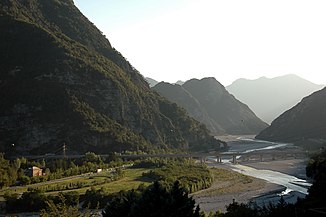
View of the Fellatal with the motorway bridge at Moggio Udinese |
||
| Data | ||
| location | Friuli , Italy | |
| River system | Tagliamento | |
| Drain over | Tagliamento → Adria | |
| Origin as Torrente Fella | at Camporosso 46 ° 31 ′ 14 ″ N , 13 ° 29 ′ 44 ″ E |
|
| Source height | approx. 1000 m slm | |
| muzzle | at Carnia coordinates: 46 ° 21 ′ 31 ″ N , 13 ° 7 ′ 13 ″ E 46 ° 21 ′ 31 ″ N , 13 ° 7 ′ 13 ″ E
|
|
| length | 54 km | |
| Drain |
MQ |
54 m³ / s |
| Left tributaries | Raccolana , Resia | |
| Communities | Tarvis , Malborgeth , Pontafel , Pietratagliata , Dogna , Chiusaforte , Resiutta and Carnia | |
The Fella ( Furlanisch Fele , Slovenian Bela ) is a river in northeast Friuli , Northern Italy and flows through the Val Canale (Canal Valley) from Camporosso (Saifnitz) near Tarvis to Pontebba (Pontafel) and the Canal del Ferro ( Iron Valley) as a southern continuation of the Canal Valley to Carnia , where it flows into the Tagliamento as a delta . The name goes back to the iron that was shipped south from Tarvisio , where iron production flourished in the 15th century.
The Fella rises as Torrente Fella (Fellabach) northwest of Camporosso , strives eastwards to the outskirts and turns there at the watershed Mediterranean – Black Sea at the Saifnitz Saddle (Sella di Camporosso) to the west. From there one speaks of the Canal Valley, and from around there or a little further in Ugovizza (Uggowitz) of Fiume Fella (Fella River). It changes its direction of flow at Pontebba to the south and flows back to the west at Chiusaforte . Only just before the delta confluence with the Tagliamento does it turn south again.
The name Fellatal is only used in general geographic terms for the course of the Fella in the western Channel Valley and through the Eisental, but not a landscape name. Two side valleys from the Carnic region reach the Fella: the valley of the Pontebbana torrent and the Aupa valley near Moggio Udinese . Three other side valleys come from the mountains of the Julian Alps from the east : Dognatal , Raccolana and Résia .
The main towns along the river are Camporosso, Malborghetto , Pontebba, Pietratagliata , Dogna , Chiusaforte, Resiutta and Carnia .
The state road (Strada statale) SS13 Pontebbana , the A23 Alpe-Adria motorway and the Pontebbana , the railway line from Villach via Tarvisio to Udine, run through the canal and iron valleys . The railway line that originally followed the valley was replaced by a new line (New Pontebbana ). The remains of the old route can still be seen in many places and are reused as a cycle path.
Picture gallery
Old road bridge over the Fella in the municipality of Chiusaforte
Fella valley between Resiutta and Moggio Udinese
Fella river at Pietratagliata
Literature / sources
- Anna Zanier with Claudio Canton e Roberto Carollo ed il contributo di Mauro Bigot: La strada ferrata della Pontebba , 2006 Senaus, Udine; ISBN 88-901571-5-1
- Furio Bianco, Aldino Bondesan, Paolo Paronuzzi, Michele Zanetti e Adriano Zanferrati: Il Tagliamento , 2006 Università di Udine, Cierre edizioni, Circolo Menocchio; ISBN 88-8314-372-8
- ^ ÖK / AMAP
- ↑ Archived copy ( Memento of the original from September 27, 2013 in the Internet Archive ) Info: The archive link was inserted automatically and has not yet been checked. Please check the original and archive link according to the instructions and then remove this notice.
- ↑ http://www.slovenia.info/?kolesarjenje=902


