
Moggio Udinese
| Moggio Udinese | ||
|---|---|---|

|
|
|
| Country | Italy | |
| region | Friuli Venezia Giulia | |
| Local name | Mueç | |
| Coordinates | 46 ° 25 ' N , 13 ° 12' E | |
| height | 341 m slm | |
| surface | 144 km² | |
| Residents | 1,676 (Dec. 31, 2019) | |
| Population density | 12 inhabitants / km² | |
| Post Code | 33015 | |
| prefix | 0433 | |
| ISTAT number | 030059 | |
| Popular name | Moggesi | |


Moggio Udinese ( Furlanisch Mueç , German Mosach / Mosnitz , Slovenian Možac / Možnicia ) is a municipality with 1676 inhabitants (as of December 31, 2019) in the northern Italian region of Friuli-Venezia Giulia . Moggio Udinese is on the A23 motorway and the Villach-Udine ( Pontebbana ) railway line .
geography
Moggio Udinese is located at 341 m above sea level at the mouth of the Aupa valley in the Eisental valley . The village, which is divided into two centers, namely Lower Moggio (341 m) and Upper Moggio (381 m), is surrounded by the high peaks of the Julian Alps and the Carnic Alps : in the south, the Plauris group dominates ( 1958 m), in the west the limestone pyramid of the Amariana dolomite mountain (1906 m), in the north the imposing Creta Grauzaria (2065 m) and the Zuc dal Bôr (2195 m) rise, while the Canin group rises to the east .
Districts
The community is divided into the following districts, some of which have already been depopulated:
- Vorchians
- Campiolo
- Dordolla
- Grauzaria
- Moggessa di Quà
- Moggessa di Là
- Monticello
- Ovedasso
- Pradis
- Chiaranda
- Stavoli
Neighboring communities
| Tolmezzo , Arta Terme | Paularo | Hermagor-Pressegger See , Pontebba |
| Amaro |
.svg)
|
Dogna |
| Venzone | Resiutta | Chiusaforte |
history
The oldest archaeological finds in and around Moggio come from the Roman Empire . In addition to coin finds, there are building remains of a guard tower or fort . The Holy Spirit Hill above the village is ideally suited to control large parts of the Fellatal valley.
The first ruler personality that can be identified by name is Count Kazelin (Cacellino) from the Bavarian family of the Aribones . The nobleman was a count palatine and thus the highest representative of the ruling court with large estates in Carinthia and Friuli, including the fort of Mosach (Moggio).
According to tradition, he planned to 1072 to the Holy Land to break up, probably because Christian fears to Jerusalem after the defeat of the Byzantine emperor in the Battle of Manzikert in 1071. Busy is that Kazelin in the years before the First Crusade , it was in 1084 or In 1085, a number of possessions were transferred to Swatobor Frederick of Bohemia, the Patriarch of Aquileia . A monastery was to be built on the site of the Moggio castle and this was to be equipped with the proceeds and property of the castle. The patriach was unable to keep his promise due to his sudden violent death. His successor Ulrich von Eppenstein (Voldarico I) then took a lot of time. Only in 1118 or on June 9th 1119 was the monastery in Moggio consecrated by Andrea Emona (Bishop of the Istrian Cittanova ). The examination of the liturgical books of the monastery showed that the monks most likely came from southern Germany and came from the Hirsauer Reform circle, but certainly not from the prince abbey of St. Gallen , which was previously known due to the origin of the patriarch or the Gallus patronage of the Adopted the monastery church in Moggio.
The details of the founding history are uncertain, as little is known about the person of Cacellino or the foundation charter, the “ Testament of Kazelins”, was recognized as a forgery or was the subject of suspicion. The patriarch was said to have built a cenobium in San Gallo, like the much more famous one in the Benedictine monastery in Switzerland where the patriarch was abbot . In any case, in order to raise the reputation of the new abbey , Voldarico left large estates in Carinthia, Friuli and Karnia to it. In addition, he granted her dominance over the places Pievi di Cavazzo, Dignano and Gorto.
In favor of the patriarchs and nobles and the power of the ruling bishops, the abbey of Moggio gained importance and splendor in both spiritual and secular terms, although there were always setbacks. In 1238 the monastery suffered a fire disaster. In 1251 there was looting by German soldiers of the Emperor Konrad IV. There were also attacks by contentious landowners who increasingly tried to withdraw their abbot goods. The most active and perhaps most respectable of the ruling abbots in Moggio was Ghiberto of Marano on Panaro, who ruled the monastery from 1329 to 1349. The main representative and confidante of Beato Patriarch Bertrando of San Genesio was determined to reform the internal discipline of the monastic community; by eliminating abuses, claiming appropriate rights, revising contracts and limits; Review of concessions, rentals and investments ; Punishment for presumptuousness and criminal acts that affected him. In fact, he himself died at the hands of assassins , sharing his sad fate with that of Patriarch Bertrando, who a year later had to end his life in the same way.
Under Ghiberto, the Benedictine abbey of Moggio experienced its peak. According to the Bulletin of Lucius III , the abbots of Moggio were spiritual . (1185) subordinated directly to the Holy See . The abbot of Moggio exercised the spiritual and secular rights of the monastery, to which many parishes and churches belonged, by means of pastors or chaplains appointed by him or appointed treasurers as administrators. They were all invited to an annual honorary visit, either on the anniversary of the monastery inauguration or of the patron saint Saint Gallus on October 16th. In the area of secular jurisprudence, the abbot was feudal lord of the Patriarch of Aquileia. By virtue of the feudal investiture , like the great princes, he was granted full and complete jurisdiction, including the right of blood and many high privileges over the entire Fellatal and the Baiuzzo country house in Friuli , included in the pure and mixed power . The scrolls of the 13th and 14th centuries show 146 land holdings as monasteries, 101 of which were directly in the region and 45 beyond the Alps , including in Carinthia. The abbey of Moggio had one vote in the Friulian general parliament . Outstanding personalities, however, did not emerge from the monastery and it did not acquire any national importance.
With the decline of the secular principate of the patriarchs was the decline of the abbey, closely linked to the order of things created by the patriarchal parliament. Looting (including 1406), illegal territorial appropriations and earthquakes hit the foundations of the already dilapidated abbey. From the 15th century, the administration of justice and administration was entrusted to their governors and procurators by the abbots who had become future owners. Thus the administration became irregular and neglected, the territorial appropriations became easier and more frequent. And a tacit transfer of regulatory and administrative rights removed power from the legal structure.
As a result of the occupation by the Venetians in 1420, the abbey came under the domination of the Venetian Empire. The monastery was subordinate to two abbots, one of whom also served as a comer from Venice . Gradually, the monastery lost its importance, as possessions and privileges and thus the income decreased. The most important of the coming abbots was Saint Carlo Borromeo, who was abbot of Moggio from 1561 to 1566. Apparently his fame among the residents of Moggio was based on foreign merits. What he did for his St. Gallus Abbey is unclear. It is not even certain that he ever came to Moggio in person. In 1771 the abbey was closed. With the death of Count Felice Faustino Savorgnano (1773) the abbey church was converted into a simple parish church and the feudal jurisdiction was put up for auction . It was auctioned for 44,000 ducats by Messrs Mangilli and Leoni, who accepted the title of Marquise of St. Gallus . In 1869 Pope Pius IX. the parish of Moggio revive the title of abbey church.
Today in Moggio Alto there are only a few rebuilt remains of the former monastery buildings, as the earthquake and subsequent rain of 1976 caused severe damage. Essential cultural assets of the former monastery were not damaged, as they have long been somewhere else. Some art treasures are in America, liturgical codes in England and some documents in the wider area.
Secular power remained with the Serenissima until 1797, when the power of the Republic of Venice fell with the peace of Campo Formio and after the brief Napoleonic interlude, Moggio came under Austrian rule in 1815 with the Congress of Vienna . With the Third War of Independence (1866) it became part of the Kingdom of Italy .
From 1908 Italy began to militarily fortify the borders against Austria-Hungary. The Alto Tagliamento stronghold included the forts of Chiusaforte, Mounte Festa, Ercole and Osoppo and other places in the Fella and Tagliamento valleys. Part of this was the fortification at Mounte Sflincis in Moggio. During the First World War the military command of the Fellatal section was housed in the village. The acts of war between the Austro-Hungarian Empire and the Kingdom of Italy have left visible traces to this day.
Population development

Attractions


- The Saint Gall (San Gallo) Abbey in Moggio di Sopra, founded in 1119 . Only the bell tower and a baptismal font remain from the old building stock. The church contains the largest organ in Friuli and a large, gilded wrought-iron chandelier, popularly known as the glogie , mother hen . A precious large wooden cross, carved from a walnut tree in 1466, hangs in a side chapel. The monastery wing has been inhabited by Poor Clares since 1987 .

Left choir fresco in the abbey church

High altar of the abbey church, behind it the organ
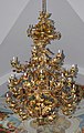
Gilded wrought iron candlestick


- Palace with a dungeon and a medieval tower in Moggio di Sopra
- Ruins of the Church of the Holy Spirit on the Colle di Santo Spirito above the Abbazia di San Gallo . Of the church, built in 1516 and last restored in 1920, only the tower and remains of the wall remain after the earthquake of 1976.
- The parish church of San Floriano in Dordolla was rebuilt in the years 1891–1895 after being destroyed by an earthquake. The ceiling painting of the central nave shows Saints Anthony and Florian above Dordolla, above Maria with the baby Jesus. In the shrine of the high altar there is a figure of St. Florian, the assistant figures are Saint Paul on the left and Peter on the right. The painting on the altar of the right aisle shows St. Blasius . Assistant figures are the Saints Joseph on the left and Antonius on the right. The weather vane on the cross of the spire is designed as a seated human figure with a pointed cap and a gold-plated crook .

inside view

Ceiling painting in the central nave

The high altar

Altar of the right aisle

The spire with a weather vane


Surroundings


In the northwestern hinterland of Moggio Udinese in the middle of the Carnic Alps are the three mountain villages Moggessa di Quà , Moggessa di Là and Stavoli , all of which are still car-free today. As there are no access roads, the old system of mule tracks is still in use. The narrow streets of the villages, in which the farmhouses are concentrated in a small space, are particularly attractive. Especially since the earthquake of 1976 there are hardly any permanent residents in the villages. Emergency quarters in containers were not possible. Some houses serve as weekend seats, many are in ruins. Only in Stavoli does a material ropeway from Campiolo di sopra supply the few residents even in winter.
A six-hour circular hike, which the Abbey of Moggio has as its starting and ending point, is considered to be one of the “most beautiful and extraordinary day hikes” in Friuli. Historically, villages are a medieval foundation of the San Gallo monastery in Moggio. Despite the altitude between 510 and 567 m above sea level, the area at the foot of Monte Palevierte ( 1785 m above sea level ) is very suitable for growing vegetables.
A steep mule path leads over a saddle, behind which the Fellatal remains, after an hour and a half walk from Moggio to Moggessa di Quá ( furlan Muiesse di ca ), in German something like "Little Mossach this side". Moggessa di Quá is about three kilometers from Moggio. At the beginning of the 20th century, 200 residents still lived largely self-sufficient in Moggessa di Quá; now there are only five. Water and electricity connections made the very lonely life in the mountains a little easier, especially in winter. Since the earthquake, the village has mainly consisted of ruins, which are gradually overgrown by scrub. In the villages there are many examples of rural architecture that are characteristic of this mountainous area. The houses, made entirely of stone, are high and have up to four storeys. They are built very closely together. The alleys are barely more than a meter wide. There are common wells in the middle of the villages. Many of the wooden balconies on the south side have already fallen into disrepair. The outside chimneys are also typical for the Fogolâre, the open stoves in Friuli. In contrast to the surrounding area, the roofs are relatively flat here.
After crossing a deep ravine, after half an hour's walk you reach Moggessa di Lá ( Muiesse di lá ), the "Little Mossach beyond". In the ravine between Moggessa di Quá and di Lá, by the Mulin brook, the last remains of a mill that was in operation until 1962 can still be seen. The connecting path between the villages is, unlike down to Moggio, less steep and in better condition, so that you can travel between the two villages by off-road motorcycle if necessary. At the beginning of the village there is a small church. However, there is no cemetery. Several cobbled streets meet in the winding core. Five houses are still inhabited. At the lower edge of the village towards the fields is the largest and most conspicuous house, an old craftsman's house with two rows of arcades lying one above the other, the lower arches of which are open. Two other surviving arches from a dilapidated house show that this style element was used here more often. There was even a school here until 1960.
A walk of around one and a half hours leads to Stavoli ( i Stâi ), which can also be reached on foot from Campiolo. stavoli refers to houses made of natural stone and wood. From the path from Moggessa di Lá, the Torrente Glagno must be crossed without a bridge (it is about 40 cm deep at the ford in normal water). There are also ruins of a mill in this gorge. The grain was brought down into the ravine to be ground and the flour then up again. Stavoli is the highest, but busiest of the three places, as food and building materials can be brought here by cable car. Due to the natural conditions (the areas around the village suitable for fields are significantly more extensive than in Moggessa) it was the largest village. Today there are gardens, potato fields, fruit trees and small-scale vineyards around the village. Most of the agricultural work has to be done by hand. The narrow paths just allow the use of so-called single - axle tractors . This is also used to transport goods between the village and the remote cable car station. One of the farmers grows lavender, which is sold in Venzone . For a farming village, architectural style elements of the 19th century such as exterior stucco and richly decorated entrance doors are striking. A memorial plaque on house no. 70 refers to the house where the Friulian poet Egiziano Pugnetti (1847–1917) was born. Outside in the fields there is a towerless church, here too without a cemetery.
Riserva Natural Val Alba nature reserve
The Riserva Natural Val Alba nature reserve is located in the mountains between Val Aupa and the Canal del Ferro . The remote area covers an area of 3,000 hectares in the municipality of Moggio Udinese. The largest mountain valley in the nature reserve is the Val Alba. The highest mountains are on the eastern border, the Monte Chiavals (2098 m) and the Monte Zuc dal Bor (2195 m). The highest mountain in the area is Monte Crostis (1898 m). The hard-to-reach area with no settlements is best reached via the Val Alba, into which it leads up a road from Pradis. The area was established in 2006 with support from the European Union and with the help of the Friuli Venezia Giulia region . It is administered by the Parco Naturale Regionale delle Prealpi Giulie in the Résia Valley .
Sons and daughters
- Max Cordignano (1851–1898), architect and builder
- Hugo Cordignano (1882–1959), painter, sculptor, musician and composer
Literature / sources
- G. Pilgram , W. Berger, W. Koroschitz, A. Pilgram-Ribitsch: The last valleys hiking and stopping off in Friuli. Drava Verlag, Klagenfurt / Celovec 2008, ISBN 978-3-85435-532-8 , p. OA
- Furio Bianco, Aldino Bondesan, Paolo Paronuzzi, Michele Zanetti, Adriano Zanferrari: Il Tagliamento. Copyright University of Udine; Cierre Verlag, 2006, ISBN 88-8314-372-8 , pp. 313-325 (in Italian).
- Heinrich Härtel: The older documents of the Moggio monastery (until 1250). Habilitation thesis, Graz, 1982.
- Roberta Costantini, Fulvio Dell'Agnese, Micol Duca, Antonella Favaro, Monica Nicoli, Alessio Pasian: Friuli-Venezia Giulia. I luoghi dell'arte. Bruno Fachin Editore, Trieste; ISBN 88-85289-57-6 , p. 213.
Web links
- Comuni-Italiani.it - Comune di Moggio Udinese with basic data
- comune.moggioudinese.ud.it - Comune di Moggio Udinese / Municipal website
- Guide Wiki Moggio Udinese
Individual evidence
- ↑ Statistiche demografiche ISTAT. Monthly population statistics of the Istituto Nazionale di Statistica , as of December 31 of 2019.
- ^ Gerhard Pilgram , Wilhelm Berger and Gerhard Maurer: Carinthia. Below through , Drava Verlag Klagenfurt / Celovec, 1998, p. 120.
- ↑ http://www.ff.uni-lj.si/oddelki/umzgod/slosr_arhkip.pdf ( page no longer available , search in web archives ) Info: The link was automatically marked as defective. Please check the link according to the instructions and then remove this notice.
- ↑ Andrej Lenarčič SLOVENSKA ZGODBA ( Memento of the original from March 5, 2016 in the Internet Archive ) Info: The archive link was inserted automatically and has not yet been checked. Please check the original and archive link according to the instructions and then remove this notice.
- ^ Gerhard Pilgram , Wilhelm Berger and Gerhard Maurer: Carinthia. Below through , Drava Verlag Klagenfurt / Celovec, 1998, p. 120.
- ^ Heinrich Härtel: The older documents of the Moggio monastery (until 1250). Habilitation thesis, Graz, 1982, p. 38.
- ^ Klaus Zimmermanns, Andrea C. Theil: Friuli and Triest. Under the lion of St. Mark and the double-headed eagle - a cultural landscape of Northern Italy. Dumont Art Guide, 1999. ISBN 3-7701-4372-8 , p. 239
- ↑ Pilgram / Berger, / Koroschitz / Pilgram-Ribitsch, The last valleys, hiking and stopping off in Friuli , pp. 113–121.
- ^ ORF Carinthia: Abandoned villages in Moggio-Udinese
- ↑ Parco naturale delle Prealpi Giulie : Riserva Naturale Val Alba / Homepage Nature Park. March 4, 2016, accessed March 4, 2016 .
- ↑ Parco naturale delle Prealpi Giulie : Parco Naturale Regionale delle Prealpi Giulie / homepage park administration. March 4, 2016, accessed March 4, 2016 .

Aiello del Friuli | Amaro | Ampezzo | Andreis | Aquileia | Arba | Arta Terme | Artegna | Attimis | Aviano | Azzano Decimo | Bagnaria Arsa | Barcis | Basiliano | Bertiolo | Bicinicco | Bordano | Brugnera | Budoia | Buja | Buttrio | Camino al Tagliamento | Campoformido | Campolongo Tapogliano | Caneva | Capriva del Friuli | Carlino | Casarsa della Delizia | Cassacco | Castelnovo del Friuli | Castions di Strada | Cavasso Nuovo | Cavazzo Carnico | Cercivento | Cervignano del Friuli | Chions | Chiopris Viscone | Chiusaforte | Cimolais | Cividale del Friuli | Claut | Clauzetto | Codroipo | Colloredo di Monte Albano | Comeglians | Cordenons | Cordovado | Cormons | Corno di Rosazzo | Coseano | Dignano | Doberdò del Lago | Dogna | Dolegna del Collio | Drenchia | Duino-Aurisina | Enemonzo | Erto e Casso | Faedis | Fagagna | Fanna | Farra d'Isonzo | Fiume Veneto | Fiumicello Villa Vicentina | Flaibano | Fogliano Redipuglia | Fontanafredda | Forgaria nel Friuli | Forni Avoltri | Forni di Sopra | Forni di Sotto | Frisanco | Gemona del Friuli | Gonars | Gorizia | Gradisca d'Isonzo | Grado | Grimacco | Latisana | Lauco | Reading Nice | Lignano Sabbiadoro | Lusevera | Magnano in Riviera | Majano | Malborghetto Valbruna | Maniago | Manzano | Marano Lagunare | Mariano del Friuli | Martignacco | Medea | Meduno | Mereto di Tomba | Moggio Udinese | Moimacco | Monfalcone | Monrupino | Montenars | Montereale Valcellina | Moraro | Morsano al Tagliamento | Mortegliano | Moruzzo | Mossa | Muggia | Muzzana del Turgnano | Nimis | Osoppo | Ovaro | Pagnacco | Palazzolo dello Stella | Palmanova | Paluzza | Pasian di Prato | Pasiano di Pordenone | Paularo | Pavia di Udine | Pinzano al Tagliamento | Pocenia | Polcenigo | Pontebba | Porcia | Pordenone | Porpetto | Povoletto | Pozzuolo del Friuli | Pradamano | Prata di Pordenone | Prato Carnico | Pravisdomini | Precenicco | Premariacco | Preone | Prepotto | Pulfero | Ragogna | Ravascletto | Raveo | Reana del Rojale | Remanzacco | Résia Valley | Resiutta | Rigolato | Rive d'Arcano | Rivignano Teor | Romans d'Isonzo | Ronchi dei Legionari | Ronchis | Roveredo in piano | Ruda | Sacile | Sagrado | San Canzian d'Isonzo | San Daniele del Friuli | San Dorligo della Valle | San Floriano del Collio | San Giorgio della Richinvelda | San Giorgio di Nogaro | San Giovanni al Natisone | San Leonardo | San Lorenzo Isontino | San Martino al Tagliamento | San Pier d'Isonzo | San Pietro al Natisone | San Quirino | San Vito al Tagliamento | San Vito al Torre | San Vito di Fagagna | Santa Maria la Longa | Sappada | Sauris | Savogna d'Isonzo | Savogna di Cividale | Sedegliano | Sequals | Sesto al Reghena | Sgonico | Socchieve | Spilimbergo | Staranzano | Stregna | Sutrio | Taipana | Talmassons | Tarcento | Tarvisio | Tavagnacco | Terzo d'Aquileia | Tolmezzo | Torreano | Torviscosa | Tramonti di Sopra | Tramonti di Sotto | Trasaghis | Travesio | Treppo Grande | Treppo Ligosullo | Tricesimo | Trieste | Trivignano Udinese | Turriaco | Udine | Vajont | Valvasone Arzene | Varmo | Venzone | Discount | Villa Santina | Villesse | Visco | Vito d'Asio | Vivaro | Zoppola | Zuglio