Monrupino
| Monrupino | ||
|---|---|---|

|
|
|
| Country | Italy | |
| region | Friuli Venezia Giulia | |
| Coordinates | 45 ° 43 ' N , 13 ° 48' E | |
| height | 418 m slm | |
| surface | 12.7 km² | |
| Residents | 863 (Dec. 31, 2019) | |
| Population density | 68 inhabitants / km² | |
| Post Code | 34016 | |
| prefix | 040 | |
| ISTAT number | 032002 | |
Monrupino (German outdated: Reippen , Slovenian: Repentabor ) is an Italian municipality with 863 inhabitants (as of December 31, 2019) in the Friuli-Venezia Giulia region .
Monrupino consists of the three villages Fernetti (Slov. Fernetiči ), Col (Italian. Zolla ), Repen (Italian. Rupingrande ) and borders directly on the municipality of Sežana ( Slovenia ). The population mainly belongs to the Slovene-speaking minority.
Until Slovenia joined the EU , the Fernetti border crossing was one of the most important transit points for Italian goods exported to the Balkans . The direct connection to international road traffic has had a positive effect on the local economy .
Monrupino is still very traditional. Many well-preserved houses in the typical architectural style of the Karst (Italian: casa carsica , Slov. Kraška hiša ), where tourists can get an insight into the customs of the area and get to know agricultural tools and furniture from the previous century, testify to this. A special attraction is the Karst wedding (ital. Nozze carsiche , Slov. Kraška ohcet ) in summer, where bridal couples are married in the traditional Karst tradition.
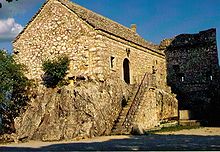
The small fortified pilgrimage church of Monrupino from the 16th century is located on a hill in the municipality. The facility offers a wide panoramic view of the surrounding area in Italy and Slovenia.
The municipality, which belonged to Imperial Austria until 1918 , was opened up in 1906 by the Karst Railway , the extension of the Wocheiner Railway, with which a direct railway connection from Trieste to Villach and Salzburg was created. It has not been used for passenger traffic in the Monrupino area for decades, and rarely for cross-border goods traffic.
At the time of the Free Territory of Trieste , the place belonged to the so-called Zone A , until 2017 to the Province of Trieste .
Web links
- Information on the municipality of Monrupino
- Maps of the karst landscape near Trieste
- Background information on Monrupino (Italian, Slovenian)
- Monrupino (German)
Individual evidence
- ↑ Statistiche demografiche ISTAT. Monthly population statistics of the Istituto Nazionale di Statistica , as of December 31 of 2019.
- ↑ Since 2003 , due to a municipal resolution, only the Slovenian place names Col and Repen are officially valid for Zolla and Rupingrande. Statuto di Monrupino (PDF; bilingual: Italian, Slovenian)


