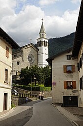
Paluzza
| Paluzza | ||
|---|---|---|

|
|
|
| Country | Italy | |
| region | Friuli Venezia Giulia | |
| Coordinates | 46 ° 32 ' N , 13 ° 1' E | |
| height | 605 m slm | |
| surface | 69.96 km² | |
| Residents | 2,056 (Dec. 31, 2019) | |
| Population density | 29 inhabitants / km² | |
| Post Code | 33026 | |
| prefix | 0433 | |
| ISTAT number | 030071 | |
| Popular name | Paluzzani | |
| Patron saint | San Daniele | |
| Website | www.comune.paluzza.ud.it | |
Paluzza ( Furlanic : Paluce ) is a north-east Italian municipality ( comune ) with 2056 inhabitants (as of December 31, 2019) in the Friuli-Venezia Giulia region .
geography
The municipality is located about 75 kilometers north-northwest of Udine in the Valle del But on the river of the same name, borders on Austria and belongs to the mountain community Comunità Montana della Carnia .
Administrative division
The municipalities of Paluzza include the following fractions : Casteons, Cleulis, Englaro, Naunina, Rivo and Timau .
traffic
During the First World War , the Italian Army's railway pioneer regiment built the Tolmezzo – Paluzza – Moscardo small railway through the Valle del But. From 1919 until the end of operations in 1931, Paluzza was the terminus of the narrow-gauge railway .
Personalities
- Peter Anton Ulrich Piutti (1750–1823), entrepreneur and businessman active in Germany
Web links
Individual evidence
- ↑ Statistiche demografiche ISTAT. Monthly population statistics of the Istituto Nazionale di Statistica , as of December 31 of 2019.


