
Polcenigo
| Polcenigo | ||
|---|---|---|

|
|
|
| Country | Italy | |
| region | Friuli Venezia Giulia | |
| Coordinates | 46 ° 2 ′ N , 12 ° 30 ′ E | |
| height | 42 m slm | |
| surface | 49.19 km² | |
| Residents | 3,157 (Dec. 31, 2019) | |
| Population density | 64 inhabitants / km² | |
| Post Code | 33070 | |
| prefix | 0434 | |
| ISTAT number | 093031 | |
| Popular name | Polcenighesi | |
| Website | Polcenigo | |

Polcenigo ( Friulian Pulcinìc ) is a northeastern Italian community in the region of Friuli Venezia Giulia . It is located west of Pordenone and has 3157 inhabitants (as of December 31, 2019). The municipality is 42 meters above sea level and covers a municipal area of 49.19 km².
The territory of the municipality is flat and lies on the Livenza .
In addition to the main town Polcenigo, the municipality includes five other villages and hamlets: Coltura, Gorgazzo, Mezzomonte, Range and San Giovanni. The neighboring communities are Budoia , Caneva , Fontanafredda and Tambre ( BL ).
Polcenigo is a member of the I borghi più belli d'Italia association (“The most beautiful places in Italy”).
The Budoia-Polcenigo train station is near Santa Lucia in the municipality of Budoia on the Gemona del Friuli – Sacile railway line .
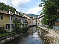
Livenza in the center of Polcenigo

Livenza with the Church of St. Trinity

Center in Polcenigo, local museum

Polcenigos center and bell tower in the background

Palazzo Lacchin
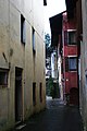
Alley view

Source of the Gorgazzo in Polcenigo

Source of the Gorgazzo


Individual evidence
- ↑ Statistiche demografiche ISTAT. Monthly population statistics of the Istituto Nazionale di Statistica , as of December 31 of 2019.
- ^ I borghi più belli d'Italia. Borghipiubelliditalia.it, accessed August 4, 2017 (Italian).
Web links

Aiello del Friuli | Amaro | Ampezzo | Andreis | Aquileia | Arba | Arta Terme | Artegna | Attimis | Aviano | Azzano Decimo | Bagnaria Arsa | Barcis | Basiliano | Bertiolo | Bicinicco | Bordano | Brugnera | Budoia | Buja | Buttrio | Camino al Tagliamento | Campoformido | Campolongo Tapogliano | Caneva | Capriva del Friuli | Carlino | Casarsa della Delizia | Cassacco | Castelnovo del Friuli | Castions di Strada | Cavasso Nuovo | Cavazzo Carnico | Cercivento | Cervignano del Friuli | Chions | Chiopris Viscone | Chiusaforte | Cimolais | Cividale del Friuli | Claut | Clauzetto | Codroipo | Colloredo di Monte Albano | Comeglians | Cordenons | Cordovado | Cormons | Corno di Rosazzo | Coseano | Dignano | Doberdò del Lago | Dogna | Dolegna del Collio | Drenchia | Duino-Aurisina | Enemonzo | Erto e Casso | Faedis | Fagagna | Fanna | Farra d'Isonzo | Fiume Veneto | Fiumicello Villa Vicentina | Flaibano | Fogliano Redipuglia | Fontanafredda | Forgaria nel Friuli | Forni Avoltri | Forni di Sopra | Forni di Sotto | Frisanco | Gemona del Friuli | Gonars | Gorizia | Gradisca d'Isonzo | Grado | Grimacco | Latisana | Lauco | Reading Nice | Lignano Sabbiadoro | Lusevera | Magnano in Riviera | Majano | Malborghetto Valbruna | Maniago | Manzano | Marano Lagunare | Mariano del Friuli | Martignacco | Medea | Meduno | Mereto di Tomba | Moggio Udinese | Moimacco | Monfalcone | Monrupino | Montenars | Montereale Valcellina | Moraro | Morsano al Tagliamento | Mortegliano | Moruzzo | Mossa | Muggia | Muzzana del Turgnano | Nimis | Osoppo | Ovaro | Pagnacco | Palazzolo dello Stella | Palmanova | Paluzza | Pasian di Prato | Pasiano di Pordenone | Paularo | Pavia di Udine | Pinzano al Tagliamento | Pocenia | Polcenigo | Pontebba | Porcia | Pordenone | Porpetto | Povoletto | Pozzuolo del Friuli | Pradamano | Prata di Pordenone | Prato Carnico | Pravisdomini | Precenicco | Premariacco | Preone | Prepotto | Pulfero | Ragogna | Ravascletto | Raveo | Reana del Rojale | Remanzacco | Résia Valley | Resiutta | Rigolato | Rive d'Arcano | Rivignano Teor | Romans d'Isonzo | Ronchi dei Legionari | Ronchis | Roveredo in piano | Ruda | Sacile | Sagrado | San Canzian d'Isonzo | San Daniele del Friuli | San Dorligo della Valle | San Floriano del Collio | San Giorgio della Richinvelda | San Giorgio di Nogaro | San Giovanni al Natisone | San Leonardo | San Lorenzo Isontino | San Martino al Tagliamento | San Pier d'Isonzo | San Pietro al Natisone | San Quirino | San Vito al Tagliamento | San Vito al Torre | San Vito di Fagagna | Santa Maria la Longa | Sappada | Sauris | Savogna d'Isonzo | Savogna di Cividale | Sedegliano | Sequals | Sesto al Reghena | Sgonico | Socchieve | Spilimbergo | Staranzano | Stregna | Sutrio | Taipana | Talmassons | Tarcento | Tarvisio | Tavagnacco | Terzo d'Aquileia | Tolmezzo | Torreano | Torviscosa | Tramonti di Sopra | Tramonti di Sotto | Trasaghis | Travesio | Treppo Grande | Treppo Ligosullo | Tricesimo | Trieste | Trivignano Udinese | Turriaco | Udine | Vajont | Valvasone Arzene | Varmo | Venzone | Discount | Villa Santina | Villesse | Visco | Vito d'Asio | Vivaro | Zoppola | Zuglio