Forni di Sotto
| Forni di Sotto | ||
|---|---|---|

|
|
|
| Country | Italy | |
| region | Friuli Venezia Giulia | |
| Coordinates | 46 ° 24 ' N , 12 ° 40' E | |
| height | 777 m slm | |
| surface | 93.54 km² | |
| Residents | 572 (Dec. 31, 2019) | |
| Population density | 6 inhabitants / km² | |
| Post Code | 33020 | |
| prefix | 0433 | |
| ISTAT number | 030042 | |
| Popular name | Fornesi | |
| Patron saint | Rosary Festival | |
| Website | Forni di Sotto | |
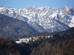
Forni di Sotto ( Friulian For Disot ) is a northeastern Italian municipality ( comune ) in the region of Friuli Venezia Giulia with 572 inhabitants (December 31, 2019). The municipality is located about 57 kilometers northwest of Udine in Carnia on the Tagliamento and the Parco naturale delle Dolomiti Friulane and belongs to the Comunità Montana della Carnia . The name comes from “forni” = “furnace”, because minerals from the surrounding mines were melted here.
traffic
The Strada Statale 52 Carnica leads through the municipality from Venzone to Innichen .
history
Forni di Sotto today has a modern structure. This is due to the fact that in May 1944, during the Second World War , shortly before the entrance to the town, a unit of the German Wehrmacht was attacked by partisans , killing a German officer . In retaliation, the village was surrounded by tanks on May 26th, the houses shot through, the stables destroyed with flamethrowers and the fleeing inhabitants shot at with machine guns . Today only the wells of the three districts around which the village was rebuilt are preserved from the time before.
Individual evidence
- ↑ Statistiche demografiche ISTAT. Monthly population statistics of the Istituto Nazionale di Statistica , as of December 31 of 2019.


