
Autostrada A23
| Autostrada A23 in Italy | |||||||||||||||||||||||||||||||||||||||||||||||||||||||||||||||||||||||||||||||||||||||||||||||||||||||||||||||||||||||||||||||||||||||||||||||||||||||||||||||||||||||||||||||||||||||||||||||||||||||||||||||||||||||||||||||||||||||||||||||||||||||||||||||||||||||||||||||||||||||||||||||||||||||||||||||||||||||||||||||||||||||||||||||||||||||||||||||||||
|
Autostrada Alpe-Adria Udine - Tarvisio |
|||||||||||||||||||||||||||||||||||||||||||||||||||||||||||||||||||||||||||||||||||||||||||||||||||||||||||||||||||||||||||||||||||||||||||||||||||||||||||||||||||||||||||||||||||||||||||||||||||||||||||||||||||||||||||||||||||||||||||||||||||||||||||||||||||||||||||||||||||||||||||||||||||||||||||||||||||||||||||||||||||||||||||||||||||||||||||||||||||

|
|||||||||||||||||||||||||||||||||||||||||||||||||||||||||||||||||||||||||||||||||||||||||||||||||||||||||||||||||||||||||||||||||||||||||||||||||||||||||||||||||||||||||||||||||||||||||||||||||||||||||||||||||||||||||||||||||||||||||||||||||||||||||||||||||||||||||||||||||||||||||||||||||||||||||||||||||||||||||||||||||||||||||||||||||||||||||||||||||||
| |
|||||||||||||||||||||||||||||||||||||||||||||||||||||||||||||||||||||||||||||||||||||||||||||||||||||||||||||||||||||||||||||||||||||||||||||||||||||||||||||||||||||||||||||||||||||||||||||||||||||||||||||||||||||||||||||||||||||||||||||||||||||||||||||||||||||||||||||||||||||||||||||||||||||||||||||||||||||||||||||||||||||||||||||||||||||||||||||||||||
| map | |||||||||||||||||||||||||||||||||||||||||||||||||||||||||||||||||||||||||||||||||||||||||||||||||||||||||||||||||||||||||||||||||||||||||||||||||||||||||||||||||||||||||||||||||||||||||||||||||||||||||||||||||||||||||||||||||||||||||||||||||||||||||||||||||||||||||||||||||||||||||||||||||||||||||||||||||||||||||||||||||||||||||||||||||||||||||||||||||||
 |
|||||||||||||||||||||||||||||||||||||||||||||||||||||||||||||||||||||||||||||||||||||||||||||||||||||||||||||||||||||||||||||||||||||||||||||||||||||||||||||||||||||||||||||||||||||||||||||||||||||||||||||||||||||||||||||||||||||||||||||||||||||||||||||||||||||||||||||||||||||||||||||||||||||||||||||||||||||||||||||||||||||||||||||||||||||||||||||||||||
| Basic data | |||||||||||||||||||||||||||||||||||||||||||||||||||||||||||||||||||||||||||||||||||||||||||||||||||||||||||||||||||||||||||||||||||||||||||||||||||||||||||||||||||||||||||||||||||||||||||||||||||||||||||||||||||||||||||||||||||||||||||||||||||||||||||||||||||||||||||||||||||||||||||||||||||||||||||||||||||||||||||||||||||||||||||||||||||||||||||||||||||
| Operator: | |||||||||||||||||||||||||||||||||||||||||||||||||||||||||||||||||||||||||||||||||||||||||||||||||||||||||||||||||||||||||||||||||||||||||||||||||||||||||||||||||||||||||||||||||||||||||||||||||||||||||||||||||||||||||||||||||||||||||||||||||||||||||||||||||||||||||||||||||||||||||||||||||||||||||||||||||||||||||||||||||||||||||||||||||||||||||||||||||||
| Start of the street: |
Gonars / Bagnaria Arsa ( 45 ° 54 ′ N , 13 ° 17 ′ E ) |
||||||||||||||||||||||||||||||||||||||||||||||||||||||||||||||||||||||||||||||||||||||||||||||||||||||||||||||||||||||||||||||||||||||||||||||||||||||||||||||||||||||||||||||||||||||||||||||||||||||||||||||||||||||||||||||||||||||||||||||||||||||||||||||||||||||||||||||||||||||||||||||||||||||||||||||||||||||||||||||||||||||||||||||||||||||||||||||||||
| End of street: |
Tarvisio ( 46 ° 32 ′ N , 13 ° 38 ′ E ) |
||||||||||||||||||||||||||||||||||||||||||||||||||||||||||||||||||||||||||||||||||||||||||||||||||||||||||||||||||||||||||||||||||||||||||||||||||||||||||||||||||||||||||||||||||||||||||||||||||||||||||||||||||||||||||||||||||||||||||||||||||||||||||||||||||||||||||||||||||||||||||||||||||||||||||||||||||||||||||||||||||||||||||||||||||||||||||||||||||
| Overall length: | 120 km | ||||||||||||||||||||||||||||||||||||||||||||||||||||||||||||||||||||||||||||||||||||||||||||||||||||||||||||||||||||||||||||||||||||||||||||||||||||||||||||||||||||||||||||||||||||||||||||||||||||||||||||||||||||||||||||||||||||||||||||||||||||||||||||||||||||||||||||||||||||||||||||||||||||||||||||||||||||||||||||||||||||||||||||||||||||||||||||||||||
|
Regions : |
|||||||||||||||||||||||||||||||||||||||||||||||||||||||||||||||||||||||||||||||||||||||||||||||||||||||||||||||||||||||||||||||||||||||||||||||||||||||||||||||||||||||||||||||||||||||||||||||||||||||||||||||||||||||||||||||||||||||||||||||||||||||||||||||||||||||||||||||||||||||||||||||||||||||||||||||||||||||||||||||||||||||||||||||||||||||||||||||||||
| Requirement for use: | Toll obligation: closed system toll-free : on the Malborghetto section - Austrian border |
||||||||||||||||||||||||||||||||||||||||||||||||||||||||||||||||||||||||||||||||||||||||||||||||||||||||||||||||||||||||||||||||||||||||||||||||||||||||||||||||||||||||||||||||||||||||||||||||||||||||||||||||||||||||||||||||||||||||||||||||||||||||||||||||||||||||||||||||||||||||||||||||||||||||||||||||||||||||||||||||||||||||||||||||||||||||||||||||||
| Development condition: | 2 × 2 and 2 × 3 lanes | ||||||||||||||||||||||||||||||||||||||||||||||||||||||||||||||||||||||||||||||||||||||||||||||||||||||||||||||||||||||||||||||||||||||||||||||||||||||||||||||||||||||||||||||||||||||||||||||||||||||||||||||||||||||||||||||||||||||||||||||||||||||||||||||||||||||||||||||||||||||||||||||||||||||||||||||||||||||||||||||||||||||||||||||||||||||||||||||||||
 |
|||||||||||||||||||||||||||||||||||||||||||||||||||||||||||||||||||||||||||||||||||||||||||||||||||||||||||||||||||||||||||||||||||||||||||||||||||||||||||||||||||||||||||||||||||||||||||||||||||||||||||||||||||||||||||||||||||||||||||||||||||||||||||||||||||||||||||||||||||||||||||||||||||||||||||||||||||||||||||||||||||||||||||||||||||||||||||||||||||
| The A23 at the Udine nord junction | |||||||||||||||||||||||||||||||||||||||||||||||||||||||||||||||||||||||||||||||||||||||||||||||||||||||||||||||||||||||||||||||||||||||||||||||||||||||||||||||||||||||||||||||||||||||||||||||||||||||||||||||||||||||||||||||||||||||||||||||||||||||||||||||||||||||||||||||||||||||||||||||||||||||||||||||||||||||||||||||||||||||||||||||||||||||||||||||||||
|
Course of the road
|
|||||||||||||||||||||||||||||||||||||||||||||||||||||||||||||||||||||||||||||||||||||||||||||||||||||||||||||||||||||||||||||||||||||||||||||||||||||||||||||||||||||||||||||||||||||||||||||||||||||||||||||||||||||||||||||||||||||||||||||||||||||||||||||||||||||||||||||||||||||||||||||||||||||||||||||||||||||||||||||||||||||||||||||||||||||||||||||||||||
The Autostrada A23 ( Italian for 'Autobahn A23'), also called Autostrada Alpe-Adria (Italian for " Alps - Adria -Autobahn"), is an Italian motorway in the north-east of the country . It is considered to be one of the most important north-south connections in Italy, as it connects the Austrian south motorway / A2 with the Italian A4 (Turin – Trieste) and thus represents the main connection between Italy and Central Europe . The A23 is around 120 km long, tolls and runs entirely in the territory of the former province of Udine ( Friuli-Venezia Giulia ).
Route

The motorway is part of the European route E55 , which runs from Helsingborg ( Sweden ) via Denmark , Germany , the Czech Republic and Austria to Kalamata in Greece .
The A23 branches off the A4 at Palmanova and then heads north. At km 13 it reaches the junction of the former provincial capital Udine Sud , where the first rest stop on the route, Zugliano , is also located. This service area ( Italian Area Servizio ) is located on both sides. Between Udine sud and Udine North leading state road 13 parallel to A23. It forms the tangenziale ovest , the city's western bypass. To the north of the Udine nord junction, the motorway now runs in a hilly area that was created by moraines in the last ice age. At kilometer 37, she reaches the Ledra service area , which can be reached from both directions.
Passing Tarcento , you reach the Gemona junction . Nearby Gemona are the cities of San Daniele del Friuli , Tricesimo , Faedis and Majano . This was the epicenter of the Friuli earthquake in 1976 . After the junction, it crosses the Tagliamento over a bridge that is 1259 m long.
Now the A23 enters the Alps . The first tunnel on the route, Lago , is 1.5 km long. The route continues west of Lake Cavazzo and reaches the next junction, Carnia - Tolmezzo . From Tolmezzo it turns east and passes the confluence between the Tagliamento and the Fella . The Campiolo service area is located here . This rest stop is only in the direction of Palmanova, towards Austria there is a parking lot where you can reach the rest stop through a connecting passage.
Via Moggio Udinese and Chiusaforte , the motorway reaches the Canale del Ferro , which was only passable by the construction of numerous tunnels. The tunnel of the same name is located here just before the Pontebba junction , which, at 2,278 m, is also the longest on the route. The Pontebba junction at km 93 is designed entirely on bridges with a length of up to 504 m. Until 1918 the border between Italy and Austria was near Pontebba .

The motorway changes direction one last time to the east and runs through the Canal Valley (Italian: Val Canale ). The La Foresta car park is located in the direction of Austria at km 96, and there is also a museum of the same name that can be reached directly from the motorway . At km 97 there is the last rest stop on the route, which can only be reached in the direction of Austria.
At km 105 she reaches the Ugovizza tollbooth . Because all vehicles have to pay the toll here, there are always 1–2 km long backlogs, especially during the summer vacation period. The Malborghetto-Valbruna semi-junction is located here, only in the direction of Palmanova .
The inconspicuous Saifnitz Saddle (Sella di Camporosso , 816 m slm ), the valley watershed of the Canal Valley, is bypassed by the motorway in the 1.8 km long Spartiacque tunnel .
There are two half-connection points at Tarvisio . Tarvisio sud has an exit to the SS 13 Pontebbana towards Austria , this is the last exit in Italy. It is only possible to drive onto the A23 in the direction of Palmanova-Udine. The Tarvisio nord junction further to the east enables access to Austria and the A2 and an exit to the city of Tarvisio. Information boards on the motorways can only be seen at both junctions Tarvisio .
Behind Tarvisio , the A23 leads to the village of Coccau (German Goggau), where it crosses the border with Austria and joins the A2 directly . The border building was removed after the permanent border controls were abolished under the Schengen Agreement .
The A2 continues to the Villach junction and beyond Graz to Vienna .
State of development


Most of the motorway today has four lanes. It has six lanes between the Udine- North and Udine-South junctions. Between kilometer 18.5 near Udine and the Carnia junction, the guard rails between the two lanes were renewed in 2009 and 2010.
Due to the modern construction criteria during the construction phase, it is considered to be one of the best motorways in Europe.
history
Before the opening of the A23, the main route from Carinthia to Italy was via Strada Statale 13 Pontebbana. However, this route was no longer suitable for the traffic on this section as early as the 1980s. With the construction of the A23, a powerful north-south connection was created.
The first section from Palmanova to Udine / South was opened in 1966 after a two-year construction period. The section between Tarvisio and Udine / North was built between 1973 and 1986 and the last section between Udine / North and South was opened in 1988 after two years of construction.
Buildings
In the section between Tarvisio and Gemona del Friuli, due to the alpine location, large parts of the route are led in tunnels or on bridges. In total, the A23 in the direction of Austria has 21.717 km, which are led in tunnels. In the direction of Palmanova it is 20.211 km.
There are also numerous bridges along the way. The longest bridge is the Tagliamento I , which crosses the river of the same name at Gemona del Friuli and has a length of 1,259 m.
Others
The La Foresta car park was tested by the ADAC in 2009 and was rated "sufficient".
administration
Between the junction of the A23 from the A4 at Palmanova to the flyover of the SS 13 at km 18.5, the motorway is managed by the Autovie Venete motorway company based in Trieste .
From kilometer 18.5 to the border with Austria near Coccau, it is managed by Autostrade per l'Italia .
Planned construction work
A connection to the A27 near Tolmezzo is planned. The A27 is to be extended from Belluno , its current end, via Pieve di Cadore , the Mauria Pass and the Tagliamento Valley to the A23.
Gemona is to be the end point of a new motorway that branches off the A28 at Pordenone and is to lead northwards via Sequals to Gemona to the A23. Current plans include extending the RA16 motorway feeder 58 km north to Sequals and then east to Gemona del Friuli to the A23 motorway. The aim is to create a connection between the A23 and A28 motorways and also to reduce travel time between Gemona and Pordenone, as Udine is bypassed to the north.
Feeder Udine sud
| Autostrada A23 in Italy | |||||||||||||||||||||||||||||||
| Raccordo Udine sud (Feeder Udine sud) |
|||||||||||||||||||||||||||||||
|
|
|||||||||||||||||||||||||||||||
| Basic data | |||||||||||||||||||||||||||||||
| Operator: | |||||||||||||||||||||||||||||||
| Start of the street: |
Pozzuolo del Friuli ( 46 ° 1 ′ N , 13 ° 14 ′ E ) |
||||||||||||||||||||||||||||||
| End of street: |
Campoformido ( 46 ° 2 ′ N , 13 ° 13 ′ E ) |
||||||||||||||||||||||||||||||
|
Regions : |
|||||||||||||||||||||||||||||||
| Requirement for use: | toll-free | ||||||||||||||||||||||||||||||
| Development condition: | 2 × 2 lanes | ||||||||||||||||||||||||||||||
|
Course of the road
|
|||||||||||||||||||||||||||||||
This short feeder connects the two bypasses (west and south bypasses) of Udine with the Udine sud toll station . The section of the motorway begins at the toll station, where after a few hundred meters you can drive onto the south or west bypass. The motorway ends at the former Basaldella traffic lights, which were removed after the underground works on the tangent were completed to prevent congestion. From here the west bypass with the name SS676 (and then SS13 after the junction with Viale Venezia) continues northwards.
photos

The A23 at Gemona

At Tolmezzo with the Carnic Alps
At Udine Sud

A23 at Tarvisio

Near the Lago di Cavazzo

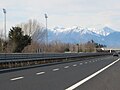
South of Udine


Web links
Individual evidence
- ↑ a b Buildings on the A23
- ↑ Traffic jam in front of the Ugovizza and Trieste / Lisert toll station , article from July 18, 2009, accessed on July 12, 2010
- ↑ Opening dates of the Autobahn (in the middle of the article)
- ↑ ADAC test results in detail ( page no longer available , search in web archives ) Info: The link was automatically marked as defective. Please check the link according to the instructions and then remove this notice.
- ↑ teonline.autostrade.it
- ↑ Article on the planned extension of the A27 motorway (Italian) ( Memento of the original from May 19, 2011 in the Internet Archive ) Info: The archive link was automatically inserted and not yet checked. Please check the original and archive link according to the instructions and then remove this notice.
| Motorways (Autostrade) |
A 1 • A 2 • A 3 • A 4 • A 5 • A 6 • A 7 • A 8 • A 9 • A 10 • A 11 • A 12 • A 13 • A 14 • A 15 • A 16 • A 18 • A 19 • A 20 • A 21 • A 22 • A 23 • A 24 • A 25 • A 26 • A 27 • A 28 • A 29 • A 30 • A 31 • A 32 • A 33 • A 34 • A 35 • A 36 • A 91 • Catania – Siracusa • Sistiana – Rabuiese • Pedemontana Veneta |
|
|
City bypasses (tangents) (Autostrade tangenziali) |
A 50 • A 51 • A 52 • A 53 • A 54 • A 55 • A 56 • A 57 • A 58 • A 59 • A 60 • A 90 / GRA |
|
|
Motorway junctions (Diramazioni autostradali) |
A 1dir • A 1var • A 2dirNA • A 2dirRC • A 4 / A 5 • A 8 / A 26 • A 11 / A 12 • A 14dir • A 18dir • A 19dir • A 21dir • A 21racc • A 26 / A 4 • A 26 / A 7 • A 29dir • A 29dirA • A 29racc • A 29racc to |
|
|
Motorway feeder (Raccordi autostradali) |
RA 1 • RA 2 • RA 3 • RA 4 • RA 5 • RA 6 • RA 8 • RA 9 • RA 10 • RA 11 • RA 12 • RA 13 • RA 14 • RA 15 • RA 16 |
|
|
Tunnel highways (Trafori) |
||
| Highways in planning |
Regional Cispadana • Nogara - Mare • Venezia - Roma • Roma - Latina |
|
| rededicated routes |
