
Malborghetto Valbruna
| Malborghetto Valbruna | ||
|---|---|---|

|
|
|
| Country | Italy | |
| region | Friuli Venezia Giulia | |
| Coordinates | 46 ° 30 ' N , 13 ° 26' E | |
| height | 721 m slm | |
| surface | 120 km² | |
| Residents | 908 (Dec. 31, 2019) | |
| Population density | 8 inhabitants / km² | |
| Post Code | 33010 | |
| prefix | 0428 | |
| ISTAT number | 030054 | |
| Popular name | Malborgether | |
| Patron saint | San Pietro | |
| Website | Malborghetto Valbruna | |

Malborghetto Valbruna ( Slovenian : Naborjet-Ovčja vas , German : Malborgeth-Wolfsbach , Friulian : Malborghèt Valbrune ) is a quadrilingual municipality with 908 inhabitants (as of December 31, 2019) in the Canal Valley in the Friuli-Venezia Giulia region .

geography
Geographical location
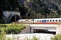
The municipality is located in the central channel valley between the municipalities of Tarvisio (Tarvis) in the east and Pontebba (Pontafel) in the west.
The main towns are characterized by the mountain peaks of the Carnic Alps in the north and the Julian Alps in the south: the Jôf di Montasio (Montasch, 2754 m), the Jôf Fuârt (Wischberg, 2666 m), the Jôf di Miezegnot (Mittagskofel, 2087 m), the Monte Osternig (Oisternig, 2052 m) and the Monte Poludnig (Poludnig, 2000 m). The Val Saisera (Seiseratal) is located in a southern side valley of the Fella , crossed by the Saisera mountain stream . The Monte Santo di Lussari (Luschariberg, 1788 m) is also located here.
Neighboring communities


| Hermagor-Pressegger See | Feistritz an der Gail , Sankt Stefan im Gailtal | Hohenthurn |
| Pontebba |
.svg)
|
Tarvisio |
| Chiusaforte | Dogna |
Community structure
The districts (fractions) are Bagni di Lusnizza (Lußnitz), Cucco (Gugg), Malborghetto (Malborgeth), Santa Caterina (St. Kathrein), Ugovizza (Uggowitz) and Valbruna (Wolfsbach).

Santa Caterina (St. Kathrein)
Pontebbana near Santa Caterina (St. Kathrein)

Bagni di Lusnizza (Lußnitz)


history
Until the High Middle Ages, the community with the then name Bambergedt (-edt = good, property), like the entire Canal Valley , belonged to the bishops of Bamberg and gained economic importance at that time. The name developed over time to Buonborgeth (buon = good) and finally, after the place was burned down by the Venetians after disputes with Venice at the end of the 14th century, to Malborgeth (mal = bad). The flourishing iron production and timber industry contributed to the economic development of the village, which is still the seat of handicrafts and small industrial businesses.
The Habsburgs built a fortification there (now called Fort Hensel ), which was occupied by the Venetians in 1616, by the French general André Masséna in 1797 and by the viceroy Eugène de Beauharnais in 1805.
From May 14 to 17, 1809, an Austrian unit under Captain Friedrich Hensel defended the fortress for four days against 15,000 French soldiers under Eugène de Beauharnais until it fell on May 17. Of the 390 Austrians, 350 were killed. Due to the loss of time, the French corps could no longer intervene in the battle of Aspern , which contributed to Archduke Charles' victory .
In 1880 the then market town of Malborgeth had 894 inhabitants. Of these, 774 were German (87%) and 66 Slovenian (7%).
After the end of the First World War, Malborgeth and the entire Canal Valley fell to Italy in 1919, although it was populated exclusively by people of German and Slovene descent. At the end of August 2003 a flood with mudslides caused damage amounting to millions.
tourism
Together with the villages of Valbruna (Wolfsbach) and Ugovizza (Uggowitz), the area represents an important region for summer retreat and winter sports. The place is also a starting point for hikes in the Julian Alps .
Attractions
Malborghetto
- The Palazzo Veneziano (17th century), used as an ethnographic museum of the municipalities in Montana-Canal del Ferro-Valcanale .

Palazzo Veneziano

Palazzo Veneziano (inner courtyard)

Ethnographic Museum in the Palazzo Veneziano


- The single-nave Gothic parish church of Santa Maria was restored in 1809 . The nave has a ribbed vault. Remnants of Gothic frescoes and stones from the 16th and 17th centuries were uncovered.
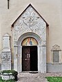
The south portal of the parish church

Interior of the parish church
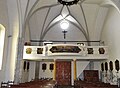
Interior view towards the gallery

Remains of Gothic frescoes

The high altar

Baptismal font in the parish church


- Memorial to the fallen and remains of the Fort Hensel dam near Malborghetto

Gothic parish church of Santa Maria

Remains of the Fort Hensel dam

Monument to the fallen for Captain Hensel


Ugovizza

- The Church of Saints Philip and Jacob ; Inside are numerous frescoes that were uncovered in 1959 . The church tower was torn away by the flood of August 29, 2003, and has been completely restored since 2009.
literature
- Roberta Costantini, Fulvio Dell'Agnese, Micol Duca, Antonella Favaro, Monica Nicoli, Alessio Pasian: Friuli-Venezia Giulia. I luoghi dell'arte , pp. 273-274; Bruno Fachin Editore, Trieste
- Anna Zanier with Claudio Canton e Roberto Carollo ed il contributo di Mauro Bigot: La strada ferrata della Pontebba , 2006 Senaus, Udine; ISBN 88-901571-5-1
- Guida del Friuli: VII. Val Canale , Udine 1991; Societá Alpina Friulana
- Claudia Fräss-Ehrfeld (ed.): Napoleon and his time, Carinthia - Inner Austria - Illyria (pages 153-198). Verlag des Geschichtsverein für Kärnten, Klagenfurt 2009, ISBN 978-3-85454-113-4 .
Web links
Individual evidence
- ↑ Statistiche demografiche ISTAT. Monthly population statistics of the Istituto Nazionale di Statistica , as of December 31 of 2019.
- ↑ Kurt F. Strasser, Harald Waitzbauer, Across the borders to Triest (Vienna 1999), p. 64.
- ^ Digby Smith: The Greenhill Napoleonic Wars Data Book , p. 304. London 1998. ISBN 1-85367-276-9
- ↑ KK Statistische Central-Commission, Special-Orts-Repertorien of the kingdoms and countries represented in the Oesterreichischen Reichsrathe. Volume V Carinthia (Vienna 1883) p. 67.

Aiello del Friuli | Amaro | Ampezzo | Andreis | Aquileia | Arba | Arta Terme | Artegna | Attimis | Aviano | Azzano Decimo | Bagnaria Arsa | Barcis | Basiliano | Bertiolo | Bicinicco | Bordano | Brugnera | Budoia | Buja | Buttrio | Camino al Tagliamento | Campoformido | Campolongo Tapogliano | Caneva | Capriva del Friuli | Carlino | Casarsa della Delizia | Cassacco | Castelnovo del Friuli | Castions di Strada | Cavasso Nuovo | Cavazzo Carnico | Cercivento | Cervignano del Friuli | Chions | Chiopris Viscone | Chiusaforte | Cimolais | Cividale del Friuli | Claut | Clauzetto | Codroipo | Colloredo di Monte Albano | Comeglians | Cordenons | Cordovado | Cormons | Corno di Rosazzo | Coseano | Dignano | Doberdò del Lago | Dogna | Dolegna del Collio | Drenchia | Duino-Aurisina | Enemonzo | Erto e Casso | Faedis | Fagagna | Fanna | Farra d'Isonzo | Fiume Veneto | Fiumicello Villa Vicentina | Flaibano | Fogliano Redipuglia | Fontanafredda | Forgaria nel Friuli | Forni Avoltri | Forni di Sopra | Forni di Sotto | Frisanco | Gemona del Friuli | Gonars | Gorizia | Gradisca d'Isonzo | Grado | Grimacco | Latisana | Lauco | Reading Nice | Lignano Sabbiadoro | Lusevera | Magnano in Riviera | Majano | Malborghetto Valbruna | Maniago | Manzano | Marano Lagunare | Mariano del Friuli | Martignacco | Medea | Meduno | Mereto di Tomba | Moggio Udinese | Moimacco | Monfalcone | Monrupino | Montenars | Montereale Valcellina | Moraro | Morsano al Tagliamento | Mortegliano | Moruzzo | Mossa | Muggia | Muzzana del Turgnano | Nimis | Osoppo | Ovaro | Pagnacco | Palazzolo dello Stella | Palmanova | Paluzza | Pasian di Prato | Pasiano di Pordenone | Paularo | Pavia di Udine | Pinzano al Tagliamento | Pocenia | Polcenigo | Pontebba | Porcia | Pordenone | Porpetto | Povoletto | Pozzuolo del Friuli | Pradamano | Prata di Pordenone | Prato Carnico | Pravisdomini | Precenicco | Premariacco | Preone | Prepotto | Pulfero | Ragogna | Ravascletto | Raveo | Reana del Rojale | Remanzacco | Résia Valley | Resiutta | Rigolato | Rive d'Arcano | Rivignano Teor | Romans d'Isonzo | Ronchi dei Legionari | Ronchis | Roveredo in piano | Ruda | Sacile | Sagrado | San Canzian d'Isonzo | San Daniele del Friuli | San Dorligo della Valle | San Floriano del Collio | San Giorgio della Richinvelda | San Giorgio di Nogaro | San Giovanni al Natisone | San Leonardo | San Lorenzo Isontino | San Martino al Tagliamento | San Pier d'Isonzo | San Pietro al Natisone | San Quirino | San Vito al Tagliamento | San Vito al Torre | San Vito di Fagagna | Santa Maria la Longa | Sappada | Sauris | Savogna d'Isonzo | Savogna di Cividale | Sedegliano | Sequals | Sesto al Reghena | Sgonico | Socchieve | Spilimbergo | Staranzano | Stregna | Sutrio | Taipana | Talmassons | Tarcento | Tarvisio | Tavagnacco | Terzo d'Aquileia | Tolmezzo | Torreano | Torviscosa | Tramonti di Sopra | Tramonti di Sotto | Trasaghis | Travesio | Treppo Grande | Treppo Ligosullo | Tricesimo | Trieste | Trivignano Udinese | Turriaco | Udine | Vajont | Valvasone Arzene | Varmo | Venzone | Discount | Villa Santina | Villesse | Visco | Vito d'Asio | Vivaro | Zoppola | Zuglio