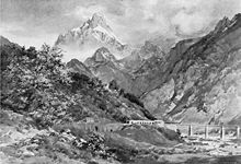
Montasch
| Montasch / Jôf di Montasio / Poliški Špik | ||
|---|---|---|
| height | 2754 m slm | |
| location | Friuli Venezia Giulia , Italy | |
| Mountains | Julian Alps | |
| Dominance | 31.5 km → Triglav | |
| Notch height | 1598 m ↓ Predilpass | |
| Coordinates | 46 ° 26 '16 " N , 13 ° 26' 0" E | |
|
|
||
The Montasch (outdated Bramkofel ) is with a height of 2754 m the highest peak of the mountain group named after him. The Montasch Group is a massive rock barrier in the Italian part of the western Julian Alps, over 20 km long, running in an east-west direction .
The west face of the Montasch is not, as often quoted in the literature, higher than the east face of the Watzmann . It begins in the Clapadories Gorge at around 1400 m and thus reaches a height of around 1350 m to the summit . The 1900 m specified in the Alpine Club Guide Julian Alps relate to the difference in altitude to be overcome on the route described there, which, however, begins in the valley floor far away from the wall.
The Montasch group consists of three mountain ranges that meet at the summit of Montasch.
- The shortest chain runs from the Bramkofel (Montasch) north over the Karnitzenturm (Torre di Carnizza, 2033 m ) to the Köpfach (Jof di Somdogna, 1861 m ) over the Somdognasattel ( 1405 m ) to the Mittagskofel ( 2089 m ).
- The second chain begins in the Forca dei Disteis ( 2241 m ) and heads west. Its peaks are the Monte Zabu ( 2244 m ), the Monte Cimone del Montasio ( 2380 m ) and the Cima Valisetta ( 2186 m ). This chain ends in the west with Monte Pecol ( 1515 m ) and Monte Jovet ( 1814 m ), two peaks directly above the Fellatal . This Cimone Train is a rock bastion torn by wild ravines. Its wild north walls plunge into the Dognatal, its steep flanks in the south into the Raccolana valley.
- The third chain branches off from the Bramkofel (Montasch) in a south-easterly direction. Its peaks from the Wischberg (Vert Montasch) ( 2661 m ) to the Weissenbacher Spitze (Cregnedul) ( 2351 m ) form a mighty wall that plunges into the Seisera, especially towards the north, with seemingly impregnable walls. In front of this chain are the wide alpine meadows of Pecol ( 1517 m ).
The first ascent took place in 1877 by Hermann Findeegg and Antonio Brussoferro . In the mountain war of the First World War , the Austrian-Italian front ran through the Montasch group from Köpfach to Cregnedul and over the Neveapass . Although the Montasch, with its vertical north faces, was invulnerable to the Austrians, the Alpini had built positions on the peaks and gaps that they held even in winter.
literature
- Hellmut Schöner , Karl Brandstätter: Area Guide Julian Alps . Bergverlag Rudolf Rother, Munich 1989, ISBN 3-7633-2406-2 .
Web links
- Montasch - Hribi.net
Individual evidence
- ^ Hermann Findegg. Retrieved July 15, 2013 .


