Autostrada A59
| Autostrada A59 in Italy | ||||||||||||||||||||||||||||||||||||||||||||||||||||
| Tangenziale di Como (Tangent Como) |
||||||||||||||||||||||||||||||||||||||||||||||||||||

|
||||||||||||||||||||||||||||||||||||||||||||||||||||
| map | ||||||||||||||||||||||||||||||||||||||||||||||||||||
| Basic data | ||||||||||||||||||||||||||||||||||||||||||||||||||||
| Operator: | ||||||||||||||||||||||||||||||||||||||||||||||||||||
| Start of the street: |
Villa Guardia ( 45 ° 46 ′ N , 9 ° 2 ′ E ) |
|||||||||||||||||||||||||||||||||||||||||||||||||||
| End of street: |
Como / Casnate con Bernate ( 45 ° 46 ′ N , 9 ° 4 ′ E ) |
|||||||||||||||||||||||||||||||||||||||||||||||||||
| Overall length: | 9 km | |||||||||||||||||||||||||||||||||||||||||||||||||||
| of which in operation: | 2.4 km | |||||||||||||||||||||||||||||||||||||||||||||||||||
| of which in planning: | 6.6 km | |||||||||||||||||||||||||||||||||||||||||||||||||||
|
Regions : |
||||||||||||||||||||||||||||||||||||||||||||||||||||
| Requirement for use: | Toll obligation : Closed system - Freeflow | |||||||||||||||||||||||||||||||||||||||||||||||||||
| Development condition: | 2 × 2 lanes | |||||||||||||||||||||||||||||||||||||||||||||||||||
| Road signs for the toll on the Tangente Como | ||||||||||||||||||||||||||||||||||||||||||||||||||||
|
Course of the road
|
||||||||||||||||||||||||||||||||||||||||||||||||||||
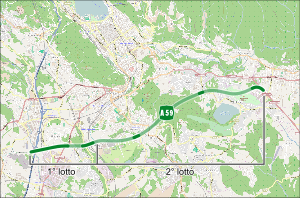
The Autostrada A59 , also known as Tangenziale di Como (Tangente von Como) , is an Italian motorway that forms the southern bypass of Como . After its completion, the entire route will have a total length of 9 km and end in Albese con Cassano . It is managed by Autostrada Pedemontana Lombarda SpA
execution
The construction of the A59 is planned in 2 lots. The first lot from the A9 to the east of Breccia was opened on May 23, 2015.
Web links
Commons : A59 (Italy) - Collection of images, videos and audio files


