Autostrada A4 (Italy)
| Autostrada A4 in Italy | ||||||||||||||||||||||||||||||||||||||||||||||||||||||||||||||||||||||||||||||||||||||||||||||||||||||||||||||||||||||||||||||||||||||||||||||||||||||||||||||||||||||||||||||||||||||||||||||||||||||||||||||||||||||||||||||||||||||||||||||||||||||||||||||||||||||||||||||||||||||||||||||||||||||||||||||||||||||||||||||||||||||||||||||||||||||||||||||||||||||||||||||||||||||||||||||||||||||||||||||||||||||||||||||||||||||||||||||||||||||||||||||||||||||||||||||||||||||||||||||||||||||||||||||||||||||||||||||||||||||||||||||||||||||||||||||||||||||||||||||||||||||||||||||||||||||||||||||||||||||||||||||||||||||||||||||||||||||||||||||||||||||||||||||||||||||||||||||||||||||||||||||||||||||||||||||||||||||||||||||||||||||||||||||||||||||||||||||||||||||||||||||||||||||||||||||||||||||||||||||||||||||||||||||||||||||||||||||||||||||||||||||||||||||||||||||||||||||||||||||||||||||
|
Autostrada Serenissima Torino - Trieste |
||||||||||||||||||||||||||||||||||||||||||||||||||||||||||||||||||||||||||||||||||||||||||||||||||||||||||||||||||||||||||||||||||||||||||||||||||||||||||||||||||||||||||||||||||||||||||||||||||||||||||||||||||||||||||||||||||||||||||||||||||||||||||||||||||||||||||||||||||||||||||||||||||||||||||||||||||||||||||||||||||||||||||||||||||||||||||||||||||||||||||||||||||||||||||||||||||||||||||||||||||||||||||||||||||||||||||||||||||||||||||||||||||||||||||||||||||||||||||||||||||||||||||||||||||||||||||||||||||||||||||||||||||||||||||||||||||||||||||||||||||||||||||||||||||||||||||||||||||||||||||||||||||||||||||||||||||||||||||||||||||||||||||||||||||||||||||||||||||||||||||||||||||||||||||||||||||||||||||||||||||||||||||||||||||||||||||||||||||||||||||||||||||||||||||||||||||||||||||||||||||||||||||||||||||||||||||||||||||||||||||||||||||||||||||||||||||||||||||||||||||||||

|
||||||||||||||||||||||||||||||||||||||||||||||||||||||||||||||||||||||||||||||||||||||||||||||||||||||||||||||||||||||||||||||||||||||||||||||||||||||||||||||||||||||||||||||||||||||||||||||||||||||||||||||||||||||||||||||||||||||||||||||||||||||||||||||||||||||||||||||||||||||||||||||||||||||||||||||||||||||||||||||||||||||||||||||||||||||||||||||||||||||||||||||||||||||||||||||||||||||||||||||||||||||||||||||||||||||||||||||||||||||||||||||||||||||||||||||||||||||||||||||||||||||||||||||||||||||||||||||||||||||||||||||||||||||||||||||||||||||||||||||||||||||||||||||||||||||||||||||||||||||||||||||||||||||||||||||||||||||||||||||||||||||||||||||||||||||||||||||||||||||||||||||||||||||||||||||||||||||||||||||||||||||||||||||||||||||||||||||||||||||||||||||||||||||||||||||||||||||||||||||||||||||||||||||||||||||||||||||||||||||||||||||||||||||||||||||||||||||||||||||||||||||
| |
||||||||||||||||||||||||||||||||||||||||||||||||||||||||||||||||||||||||||||||||||||||||||||||||||||||||||||||||||||||||||||||||||||||||||||||||||||||||||||||||||||||||||||||||||||||||||||||||||||||||||||||||||||||||||||||||||||||||||||||||||||||||||||||||||||||||||||||||||||||||||||||||||||||||||||||||||||||||||||||||||||||||||||||||||||||||||||||||||||||||||||||||||||||||||||||||||||||||||||||||||||||||||||||||||||||||||||||||||||||||||||||||||||||||||||||||||||||||||||||||||||||||||||||||||||||||||||||||||||||||||||||||||||||||||||||||||||||||||||||||||||||||||||||||||||||||||||||||||||||||||||||||||||||||||||||||||||||||||||||||||||||||||||||||||||||||||||||||||||||||||||||||||||||||||||||||||||||||||||||||||||||||||||||||||||||||||||||||||||||||||||||||||||||||||||||||||||||||||||||||||||||||||||||||||||||||||||||||||||||||||||||||||||||||||||||||||||||||||||||||||||||
| map | ||||||||||||||||||||||||||||||||||||||||||||||||||||||||||||||||||||||||||||||||||||||||||||||||||||||||||||||||||||||||||||||||||||||||||||||||||||||||||||||||||||||||||||||||||||||||||||||||||||||||||||||||||||||||||||||||||||||||||||||||||||||||||||||||||||||||||||||||||||||||||||||||||||||||||||||||||||||||||||||||||||||||||||||||||||||||||||||||||||||||||||||||||||||||||||||||||||||||||||||||||||||||||||||||||||||||||||||||||||||||||||||||||||||||||||||||||||||||||||||||||||||||||||||||||||||||||||||||||||||||||||||||||||||||||||||||||||||||||||||||||||||||||||||||||||||||||||||||||||||||||||||||||||||||||||||||||||||||||||||||||||||||||||||||||||||||||||||||||||||||||||||||||||||||||||||||||||||||||||||||||||||||||||||||||||||||||||||||||||||||||||||||||||||||||||||||||||||||||||||||||||||||||||||||||||||||||||||||||||||||||||||||||||||||||||||||||||||||||||||||||||||
| Basic data | ||||||||||||||||||||||||||||||||||||||||||||||||||||||||||||||||||||||||||||||||||||||||||||||||||||||||||||||||||||||||||||||||||||||||||||||||||||||||||||||||||||||||||||||||||||||||||||||||||||||||||||||||||||||||||||||||||||||||||||||||||||||||||||||||||||||||||||||||||||||||||||||||||||||||||||||||||||||||||||||||||||||||||||||||||||||||||||||||||||||||||||||||||||||||||||||||||||||||||||||||||||||||||||||||||||||||||||||||||||||||||||||||||||||||||||||||||||||||||||||||||||||||||||||||||||||||||||||||||||||||||||||||||||||||||||||||||||||||||||||||||||||||||||||||||||||||||||||||||||||||||||||||||||||||||||||||||||||||||||||||||||||||||||||||||||||||||||||||||||||||||||||||||||||||||||||||||||||||||||||||||||||||||||||||||||||||||||||||||||||||||||||||||||||||||||||||||||||||||||||||||||||||||||||||||||||||||||||||||||||||||||||||||||||||||||||||||||||||||||||||||||||
| Operator: | ||||||||||||||||||||||||||||||||||||||||||||||||||||||||||||||||||||||||||||||||||||||||||||||||||||||||||||||||||||||||||||||||||||||||||||||||||||||||||||||||||||||||||||||||||||||||||||||||||||||||||||||||||||||||||||||||||||||||||||||||||||||||||||||||||||||||||||||||||||||||||||||||||||||||||||||||||||||||||||||||||||||||||||||||||||||||||||||||||||||||||||||||||||||||||||||||||||||||||||||||||||||||||||||||||||||||||||||||||||||||||||||||||||||||||||||||||||||||||||||||||||||||||||||||||||||||||||||||||||||||||||||||||||||||||||||||||||||||||||||||||||||||||||||||||||||||||||||||||||||||||||||||||||||||||||||||||||||||||||||||||||||||||||||||||||||||||||||||||||||||||||||||||||||||||||||||||||||||||||||||||||||||||||||||||||||||||||||||||||||||||||||||||||||||||||||||||||||||||||||||||||||||||||||||||||||||||||||||||||||||||||||||||||||||||||||||||||||||||||||||||||||
| Start of the street: |
Turin ( 45 ° 7 ′ N , 7 ° 43 ′ E ) |
|||||||||||||||||||||||||||||||||||||||||||||||||||||||||||||||||||||||||||||||||||||||||||||||||||||||||||||||||||||||||||||||||||||||||||||||||||||||||||||||||||||||||||||||||||||||||||||||||||||||||||||||||||||||||||||||||||||||||||||||||||||||||||||||||||||||||||||||||||||||||||||||||||||||||||||||||||||||||||||||||||||||||||||||||||||||||||||||||||||||||||||||||||||||||||||||||||||||||||||||||||||||||||||||||||||||||||||||||||||||||||||||||||||||||||||||||||||||||||||||||||||||||||||||||||||||||||||||||||||||||||||||||||||||||||||||||||||||||||||||||||||||||||||||||||||||||||||||||||||||||||||||||||||||||||||||||||||||||||||||||||||||||||||||||||||||||||||||||||||||||||||||||||||||||||||||||||||||||||||||||||||||||||||||||||||||||||||||||||||||||||||||||||||||||||||||||||||||||||||||||||||||||||||||||||||||||||||||||||||||||||||||||||||||||||||||||||||||||||||||||||||
| End of street: |
Duino-Aurisina ( 45 ° 46 ′ N , 13 ° 39 ′ E ) |
|||||||||||||||||||||||||||||||||||||||||||||||||||||||||||||||||||||||||||||||||||||||||||||||||||||||||||||||||||||||||||||||||||||||||||||||||||||||||||||||||||||||||||||||||||||||||||||||||||||||||||||||||||||||||||||||||||||||||||||||||||||||||||||||||||||||||||||||||||||||||||||||||||||||||||||||||||||||||||||||||||||||||||||||||||||||||||||||||||||||||||||||||||||||||||||||||||||||||||||||||||||||||||||||||||||||||||||||||||||||||||||||||||||||||||||||||||||||||||||||||||||||||||||||||||||||||||||||||||||||||||||||||||||||||||||||||||||||||||||||||||||||||||||||||||||||||||||||||||||||||||||||||||||||||||||||||||||||||||||||||||||||||||||||||||||||||||||||||||||||||||||||||||||||||||||||||||||||||||||||||||||||||||||||||||||||||||||||||||||||||||||||||||||||||||||||||||||||||||||||||||||||||||||||||||||||||||||||||||||||||||||||||||||||||||||||||||||||||||||||||||||
| Overall length: | 522.4 km | |||||||||||||||||||||||||||||||||||||||||||||||||||||||||||||||||||||||||||||||||||||||||||||||||||||||||||||||||||||||||||||||||||||||||||||||||||||||||||||||||||||||||||||||||||||||||||||||||||||||||||||||||||||||||||||||||||||||||||||||||||||||||||||||||||||||||||||||||||||||||||||||||||||||||||||||||||||||||||||||||||||||||||||||||||||||||||||||||||||||||||||||||||||||||||||||||||||||||||||||||||||||||||||||||||||||||||||||||||||||||||||||||||||||||||||||||||||||||||||||||||||||||||||||||||||||||||||||||||||||||||||||||||||||||||||||||||||||||||||||||||||||||||||||||||||||||||||||||||||||||||||||||||||||||||||||||||||||||||||||||||||||||||||||||||||||||||||||||||||||||||||||||||||||||||||||||||||||||||||||||||||||||||||||||||||||||||||||||||||||||||||||||||||||||||||||||||||||||||||||||||||||||||||||||||||||||||||||||||||||||||||||||||||||||||||||||||||||||||||||||||||
|
Regions : |
||||||||||||||||||||||||||||||||||||||||||||||||||||||||||||||||||||||||||||||||||||||||||||||||||||||||||||||||||||||||||||||||||||||||||||||||||||||||||||||||||||||||||||||||||||||||||||||||||||||||||||||||||||||||||||||||||||||||||||||||||||||||||||||||||||||||||||||||||||||||||||||||||||||||||||||||||||||||||||||||||||||||||||||||||||||||||||||||||||||||||||||||||||||||||||||||||||||||||||||||||||||||||||||||||||||||||||||||||||||||||||||||||||||||||||||||||||||||||||||||||||||||||||||||||||||||||||||||||||||||||||||||||||||||||||||||||||||||||||||||||||||||||||||||||||||||||||||||||||||||||||||||||||||||||||||||||||||||||||||||||||||||||||||||||||||||||||||||||||||||||||||||||||||||||||||||||||||||||||||||||||||||||||||||||||||||||||||||||||||||||||||||||||||||||||||||||||||||||||||||||||||||||||||||||||||||||||||||||||||||||||||||||||||||||||||||||||||||||||||||||||||
| Requirement for use: | Toll obligation: closed system toll-free : on the Turin - Rondissone sections ; Junction A50 - Cinisello Balsamo and Monfalcone est - Duino |
|||||||||||||||||||||||||||||||||||||||||||||||||||||||||||||||||||||||||||||||||||||||||||||||||||||||||||||||||||||||||||||||||||||||||||||||||||||||||||||||||||||||||||||||||||||||||||||||||||||||||||||||||||||||||||||||||||||||||||||||||||||||||||||||||||||||||||||||||||||||||||||||||||||||||||||||||||||||||||||||||||||||||||||||||||||||||||||||||||||||||||||||||||||||||||||||||||||||||||||||||||||||||||||||||||||||||||||||||||||||||||||||||||||||||||||||||||||||||||||||||||||||||||||||||||||||||||||||||||||||||||||||||||||||||||||||||||||||||||||||||||||||||||||||||||||||||||||||||||||||||||||||||||||||||||||||||||||||||||||||||||||||||||||||||||||||||||||||||||||||||||||||||||||||||||||||||||||||||||||||||||||||||||||||||||||||||||||||||||||||||||||||||||||||||||||||||||||||||||||||||||||||||||||||||||||||||||||||||||||||||||||||||||||||||||||||||||||||||||||||||||||
| Development condition: | 2 × 2, 2 × 3, 2 × 3 including dynamic lane and 4 × 2 lanes | |||||||||||||||||||||||||||||||||||||||||||||||||||||||||||||||||||||||||||||||||||||||||||||||||||||||||||||||||||||||||||||||||||||||||||||||||||||||||||||||||||||||||||||||||||||||||||||||||||||||||||||||||||||||||||||||||||||||||||||||||||||||||||||||||||||||||||||||||||||||||||||||||||||||||||||||||||||||||||||||||||||||||||||||||||||||||||||||||||||||||||||||||||||||||||||||||||||||||||||||||||||||||||||||||||||||||||||||||||||||||||||||||||||||||||||||||||||||||||||||||||||||||||||||||||||||||||||||||||||||||||||||||||||||||||||||||||||||||||||||||||||||||||||||||||||||||||||||||||||||||||||||||||||||||||||||||||||||||||||||||||||||||||||||||||||||||||||||||||||||||||||||||||||||||||||||||||||||||||||||||||||||||||||||||||||||||||||||||||||||||||||||||||||||||||||||||||||||||||||||||||||||||||||||||||||||||||||||||||||||||||||||||||||||||||||||||||||||||||||||||||||
| The A4 at the Meolo - Roncade junction | ||||||||||||||||||||||||||||||||||||||||||||||||||||||||||||||||||||||||||||||||||||||||||||||||||||||||||||||||||||||||||||||||||||||||||||||||||||||||||||||||||||||||||||||||||||||||||||||||||||||||||||||||||||||||||||||||||||||||||||||||||||||||||||||||||||||||||||||||||||||||||||||||||||||||||||||||||||||||||||||||||||||||||||||||||||||||||||||||||||||||||||||||||||||||||||||||||||||||||||||||||||||||||||||||||||||||||||||||||||||||||||||||||||||||||||||||||||||||||||||||||||||||||||||||||||||||||||||||||||||||||||||||||||||||||||||||||||||||||||||||||||||||||||||||||||||||||||||||||||||||||||||||||||||||||||||||||||||||||||||||||||||||||||||||||||||||||||||||||||||||||||||||||||||||||||||||||||||||||||||||||||||||||||||||||||||||||||||||||||||||||||||||||||||||||||||||||||||||||||||||||||||||||||||||||||||||||||||||||||||||||||||||||||||||||||||||||||||||||||||||||||||
|
Course of the road
|
||||||||||||||||||||||||||||||||||||||||||||||||||||||||||||||||||||||||||||||||||||||||||||||||||||||||||||||||||||||||||||||||||||||||||||||||||||||||||||||||||||||||||||||||||||||||||||||||||||||||||||||||||||||||||||||||||||||||||||||||||||||||||||||||||||||||||||||||||||||||||||||||||||||||||||||||||||||||||||||||||||||||||||||||||||||||||||||||||||||||||||||||||||||||||||||||||||||||||||||||||||||||||||||||||||||||||||||||||||||||||||||||||||||||||||||||||||||||||||||||||||||||||||||||||||||||||||||||||||||||||||||||||||||||||||||||||||||||||||||||||||||||||||||||||||||||||||||||||||||||||||||||||||||||||||||||||||||||||||||||||||||||||||||||||||||||||||||||||||||||||||||||||||||||||||||||||||||||||||||||||||||||||||||||||||||||||||||||||||||||||||||||||||||||||||||||||||||||||||||||||||||||||||||||||||||||||||||||||||||||||||||||||||||||||||||||||||||||||||||||||||||
The Autostrada A4 ( Italian for 'Motorway A4'), also called Autostrada Serenissima , is an Italian motorway in the north of the country that crosses the entire Po Valley from Turin via Milan , Verona and Venice to Sistiana near Trieste . With a length of 517 km, it is the third longest motorway in Italy after the A1 and A14 .
The A4 has always been considered one of the most important national and European transport axes, as it connects the Iberian Peninsula with the Balkans .
In March 2003, the A4 between Cessalto and Noventa di Piave suffered the most serious pile-up in Italian history. More than 250 vehicles crashed into one another, killing 14 people and injuring 98 others, ten of them life-threatening.
Sections and Course
The A4 motorway crosses the entire Po Valley on its way from west to east and runs through the regions of Piedmont , Lombardy , Veneto and Friuli-Venezia Giulia .
The A4 can be divided into three sections:
- Turin - Milan
- Milan - Venice
- Venice - Sistiana
Turin – Milan
The 125 km long six-lane section between Turin and Milan is one of the oldest in Italy. After three years of construction, it was opened on October 25, 1932.
The A4 begins in the northeast of the city of Turin , the capital of the Piedmont region . There is a connection with the A55 and the A5 . Use from the start of the motorway near Turin to the Rondissone junction (length: 24 km) is free.
The A4 runs northeast past the towns of Chivasso and Santhià to Novara . At Santhià, the two motorway junctions A4 / A5 and A4 / A26 intersect, which connect the A5 and the A26 ( Genoa - Gravellona Toce ) with the A4. To the west of Novara the A4 crosses with the A26 motorway.
Here it changes its course to the east and reaches Lombard territory. The border between Piedmont and Lombardy is formed by the Ticino .
The motorway reaches the capital of the Lombardy region, Milan . The 4 km long section between Ghisolfa and Certosa at the gates of Milan is chronically congested. This is primarily due to the fact that the traffic flows from the south ( A1 ), the north ( A8 / A9 ) and the city itself meet there. The motorway is toll-free between the Milano Ghisolfa and Milano Est tollbooths . Here it crosses the A50 (west bypass Milan) and the A8 .
Milan – Venice
This section connects seamlessly with the first at the Milano Est tollbooth . In the urban area of Milan, it crosses the A52 (Milan northern bypass ) and the A51 (Milan eastern bypass ) .
The motorway leads eastwards past the villages of Sesto San Giovanni , Cormano and near the city of Monza to Trezzo sull'Adda , where the A4 crosses the Adda . The motorway has eight lanes between Milan and Bergamo (4 in each direction).
At Bergamo, the motorway runs southeast near Lake Iseo to Brescia , where the A21 motorway (Turin – Brescia; this motorway runs further south than the A4) joins the A4. The motorway between Bergamo and Brescia has six lanes (three lanes in each direction).
It then reaches Desenzano del Garda and runs along the southern shore of Lake Garda . After the Sirmione junction , it reaches the Veneto region. The 170 km long section between Brescia and Venice has six lanes.
East of the provincial capital Verona it crosses with the Brenner motorway (A22), which leads over the Brenner to Innsbruck and south to Modena . The line has a total of seven junctions between Verona and Vicenza . South of the provincial capital Vicenza are the only two tunnels on the A4, which are necessary to pass through the Colli Berici wine-growing region . The motorway continues eastwards in this section.
East of Vicenza there is a connection to the A31 , which leads to Piovene Rocchette . The further course between Vicenza and Padua runs again through flat land. The A4 intersects with the A13 (Padua - Bologna ) near Padua .
Venice bypass
In the village of Dolo the motorway turns north. The A4 is part of the Passante di Mestre here .
A route around Venice is called the Tangenziale di Mestre . The term “tangential” implies that the city is “touched”, much like a tangent touches a circle; Mestre is a district of Venice. There are several interchanges on this bypass, including a. to the airport and the A27 (Mestre– Belluno ).
Since this section has to cope with a very high volume of traffic, the construction of a 32 km long alternative route was started in 2004, which is now part of the A4. It was opened to traffic on February 8, 2009. The route is managed by CAV SpA ( Concessioni Autostradali Venete ), which is 50% owned by ANAS and 50% by the Veneto region. The Passante di Mestre has six lanes and is provided with hard shoulder. Along the course, the Passante has the interchanges Preganziol (opened on February 18, 2009), Spinea (opened on July 15, 2009) and Martellago-Scorzè (opened on April 1, 2015). The junction with the A27 was opened on May 24, 2009. The route is led in 9 sections in trenches as well as over 8 underpasses and 4 bridges.
The former section of the A4, the Tangenziale di Mestre , is now classified as the A57 . The A4 was interrupted in this area by the Venezia / Est and Venezia / Mestre tollbooths and was therefore toll-free. Since the opening of the Passante, it has been subject to tolls from Trieste to Milan .
The Passante di Mestre is part of an infrastructure project to solve the traffic problem on the Tangenziale di Mestre. → for further details see here
Venice – Sistiana
This 120 km long section has four lanes (2 lanes in each direction) with hard shoulder. Only the bridge over the Tagliamento is without hard shoulder. The route is 60 km in Veneto. This section of the A4 begins here at Quarto d'Altino (junction with the A57). The motorway runs slightly northeast and has the junctions San Donà di Piave , Cessalto , San Stino di Livenza and Portogruaro . The route crosses the province of Venice and the Livenza and Piave rivers . At Portogruaro the A28 branches off to Conegliano .
The Tagliamento forms the border between Veneto and Friuli Venezia Giulia. The Latisana - Lignano junction is only 1 km from the regional border. Since the previous toll station was chronically overloaded in summer due to tourist traffic and backlogs of around 20 km on the A4 were not uncommon, a new toll station was built around 1 km eastwards in 2009. The cost was 50 million euros. The new toll booth was opened on June 12, 2009.
After passing the San Giorgio di Nogaro - Porpetto junction , the motorway reaches the junction with the A23 , which leads to Tarvisio ( UD ) and Villach ( Austria ). Here the motorway changes direction and now runs southeast past Palmanova . At Villesse it crosses the Isonzo . This is where the A34 branches off , which connects the city of Gorizia and the Slovenian H4 with the Italian motorway network.
In the last 20 kilometers, the A4 reaches the Karst and thus more hilly area. It leads past the industrial and port city of Monfalcone and then follows the coast of the Adriatic Sea . The end of the A4 is near the town of Sistiana . After the Trieste / Lisert toll station, it changes to the RA13 , which leads to Trieste and beyond to Slovenia to the Adriatic port of Koper.
history
The A4 is one of the oldest motorways in Italy. Sections of today's A4 were built as early as the 1930s. The entire length of the A4 has been completed since 1972.
Before World War II
The construction of the motorway before the Second World War was initiated by the fascists under Benito Mussolini , who used the construction of the motorway for their propaganda purposes. The establishment of an entire motorway network was not so important, but rather the aim was to better connect the individual cities with one another. Therefore, many sections were built between two cities (for example between Padua and Venice), but there was still no talk of a connected motorway. An exception was the Autostrada Pedemontana ( motorway at the foot of the mountains ), which ran continuously from Turin via Milan to Brescia and used the same route as today's A4. It was opened in 1932. Between Turin and Milan it was designated as No. 1, from Milan to Bergamo as No. 3 and from Bergamo to Brescia as No. 4.
All A4 motorway projects were financed by private motorway companies, for whose liabilities the state provided guarantees.
The first section of today's A4 was opened to traffic between Milan and Bergamo on September 24, 1927 . This 48.6 km long section was planned by Bergamasca per la Costruzione a l'Ecercizio, Autovie and completed in just one year of construction. It linked the economic centers of Bergamo and Milan.
In 1931 the section from Bergamo to Brescia followed, which was also built for a year. This 45.6 km long route was opened on August 29, 1931. On October 25, 1932, the 129 km long section between Turin and Milan was finally opened after just one year of construction. The Autostrada Torino-Milano company was responsible for this section. This was subordinate to the Fiat group, which secured the financing.
Between 1929 and 1933 the motorway section between Venice and Padua was also built. The Società delle Autostrade di Venezia e Padova was responsible for the construction . The 24.6 km long section was opened on October 15, 1933. This section was numbered 5.
post war period
After the Second World War, the construction of the motorway did not resume until the early 1960s. In 1962 the section between Brescia and Padua was completed, on February 22, 1970 the line between Mestre and Sistiana was opened. The Tangenziale di Mestre (now the A57 ) was opened as the last section of the A4 on September 3, 1972.
administration
The entire route is managed by various operating companies. These are in detail:
- From SATAP SpA (Società Autostrada Torino – Alessandria – Piacenza SpA) between the beginning of the A4 and kilometer 125 near Milan,
- from the Autostrade per l'Italia SpA between kilometers 125 and 217.6 at the junction of the A21 near Brescia
- from Brescia to Padua / Est (between kilometers 217.6 and 363.6) from the autostrada Brescia – Verona – Vicenza – Padova
- from the Concessioni Autostradali Venete (CAV) from kilometer 363.724 to the eastern confluence of the A57
- and from the Autovie Venete between km 406.7 and the end at Sistiana (km 522.4).
Kilometers and tolls
In contrast to the other long motorways in the country, the A4 was not a continuous motorway for a long time. The motorway was interrupted at Milan and Venice. This is where the kilometers started from the beginning . In the meantime, the entire route of the A4 has continuous kilometers.
Furthermore, the motorway is not toll everywhere . While part of the motorway in the urban area of Milan is still toll-free today, the A4 near Venice was also toll-free until 2009. Due to the construction of the Passante di Mestre, however, it is now subject to tolls from Milan to Sistiana.
Construction projects on the A4
Several construction projects are currently planned on the A4, the most important being the six-lane expansion between Venice and Gorizia.
Six-lane expansion Venice-Gorizia
Due to the enormous volume of traffic in this section, the six-lane expansion between the confluence of the A57 and the junction of the RA17 to Gorizia is planned. The RA17 was expanded into a motorway and has been called the A34 motorway since autumn 2013 .
This project is also being financed with 1 billion euros by the European Investment Bank . The total cost is 2.3 billion euros.
The A4 is divided into 4 construction lots , the construction work has already started on individual parts of the route. At the same time as the construction work on the A4, the new high-speed line Venice-Trieste is being built parallel to the motorway .
The construction work on the first section between Quarto d'Altino and San Donà di Piave should originally have started in 2010, but the start has been delayed to November 25, 2011. Construction work was completed on November 17, 2014. The construction costs are 448 million euros for 18.55 km. A new toll booth is to be built at Meolo by 2013 , which will have 15 lanes, 9 exits, 4 entrances and 2 special lanes for trucks.
The section between San Donà di Piave and Alvisopoli with a length of 35 km is currently not being expanded. A new junction is to be built in Alvispoli, near the border with Friuli-Venezia Giulia. This is to relieve the Latisana junction, as the holiday traffic branches off to the seaside resort of Bibione near Alvispoli, and that to Lignano near Latisana.
The construction work between the bridge over the Tagliamento near Latisana and Gonars (node A23) with a total length of 24 km should be completed in 2014, but construction has not yet started. And the last section between Gonars and Villesse (junction RA17-A34) was originally supposed to be expanded to six lanes in 2014. Originally, the A4 was supposed to be drivable with six lanes throughout this section in 2015.
In December 2011 there was the green light for further expansion plans from the Minister of Transport Corrado Passera and the Italian Prime Minister Mario Monti .
However, no construction work is currently starting between San Dona di Piave and Villesse. In 2012 and 2013 there were financing problems around a consortium with 8 banks, which should secure the further construction. In January 2013 it was announced that a loan of 1.2 billion had been made available, but the financing was not secured due to the current difficult situation in the banking sector. In February 2013, the President of Autovie Venete expressed skepticism about successful funding. Before 2017, the A4 will probably not be expanded to three lanes in this section.
In addition, the A34 was expanded into a motorway, creating a powerful connection to Ljubljana in Slovenia .
Expansion of the Trieste / Lisert tollbooth
The expansion of the Trieste / Lisert tollbooth (near Sistiana) is currently being examined. Traffic jams are becoming more and more frequent here , as the proportion of trucks increased by 40% between 2005 and 2008. The toll station is currently equipped with four slopes (entrance) and seven (exit).
Eastern feeder to Chivasso
| Autostrada A4 in Italy | |||||||||||||||||||||||||||||||||||||
|
Raccordo Est di Chivasso (eastern feeder to Chivasso) |
|||||||||||||||||||||||||||||||||||||

|
|||||||||||||||||||||||||||||||||||||
| Basic data | |||||||||||||||||||||||||||||||||||||
| Operator: | |||||||||||||||||||||||||||||||||||||
| Start of the street: |
Chivasso ( 45 ° 14 ′ N , 7 ° 55 ′ E ) |
||||||||||||||||||||||||||||||||||||
| End of street: |
Verolengo ( 45 ° 11 ′ N , 7 ° 58 ′ E ) |
||||||||||||||||||||||||||||||||||||
| Overall length: | 5 km | ||||||||||||||||||||||||||||||||||||
|
Regions : |
|||||||||||||||||||||||||||||||||||||
| Requirement for use: | toll-free | ||||||||||||||||||||||||||||||||||||
| Development condition: | 2 × 2 lanes | ||||||||||||||||||||||||||||||||||||
|
Course of the road
|
|||||||||||||||||||||||||||||||||||||
At the beginning of the nineties of the 20th century, as part of the renovation of the Turin-Milan motorway, the SATAP operator received the order to modernize the former SP91, which routed traffic from the eastern area of Chivasso to the motorway. The operating company integrated this section into its motorway system and classified it as an extension of the Chivasso est exit . This slip road is five kilometers long, has a single junction, and is marked A4 on the panels marking the motorway numbers, as this is the motorway on which it depends.
Branches
The A4 branches off near the Piedmontese city of Santhià to allow connection to the A5 ( Turin - Aosta - Mont Blanc ( France )) and A26 ( Genoa Voltri - Gravellona Toce) motorways . This branch is called Diramazione in Italian (plural: Diramazioni ) and is usually abbreviated to “dir” .
Diramazione Ivrea – Santhià
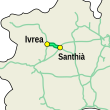
The A4 / A5 junction Ivrea – Santhià (Italian: Autostrada A4 / A5 Diramazione Ivrea – Santhià ) branches off the A4 at Santhià in a westerly direction and joins the A5 at Ivrea (more precisely at Pavone Canavese ). There is only one junction at Albiano d'Ivrea on this almost 24 km long connecting motorway . Originally the name A18 was chosen for this route, but later withdrawn due to its short length. The A18 now runs between Messina and Catania in Sicily.
Diramazione Stroppiana – Santhià
The A4 / A26 junction Stroppiana – Santhià (Italian: Autostrada A4 / A26 Diramazione Stroppiana – Santhià ) branches off from the A4 at Santhià in an easterly direction and joins the A26 at Stroppiana . This connection is around 30 km long and also has only one exit, " Vercelli -Ovest".
Web links
- Homepage of the operating company SATAP
- Homepage of the operating company Autostrade per l'Italia
- Homepage of the operating company Autostrada Brescia-Verona-Vicenza-Padova
- Homepage of the operating company CAV
- Homepage of the operating company Autovie Venete
Individual evidence
- ↑ a b Course, junctions, change of responsibilities and kilometers of the entire route
- ↑ "A pile-up kills 14" . spiegel.de. March 13, 2003. Retrieved August 18, 2010.
- ↑ L'articolo del Gazzettino . Carta.ilgazzettino.it. Archived from the original on March 23, 2015. Info: The archive link was inserted automatically and has not yet been checked. Please check the original and archive link according to the instructions and then remove this notice. Retrieved August 18, 2010.
- ^ Report of the Tribuna Treviso . Tribunatreviso.gelocal.it. February 18, 2009. Accessed on August 18, 2010. ( Page no longer available , search in web archives ) Info: The link was automatically marked as defective. Please check the link according to the instructions and then remove this notice.
- ^ Corriere del Veneto: Report of the corrieredelveneto . Corrieredelveneto.corriere.it. July 14, 2009. Retrieved August 18, 2010.
- ↑ Report of NuoveVenezia . Nuovavenezia.gelocal.it. May 23, 2009. Archived from the original on November 9, 2009. Info: The archive link was automatically inserted and not yet checked. Please check the original and archive link according to the instructions and then remove this notice. Retrieved August 18, 2010.
- ↑ la carta dei servizi (PDF; 1.0 MB) cavspa.it. Archived from the original on August 26, 2014. Info: The archive link was inserted automatically and has not yet been checked. Please check the original and archive link according to the instructions and then remove this notice. Retrieved August 18, 2010.
- ↑ "Aperto il nuovo casello" , Report of the Bora.La of 12 June 2009
- ^ Structures along the A4
- ↑ The first "Autostradas" in Italy (PDF) Archived from the original on July 1, 2011. Info: The archive link was inserted automatically and has not yet been checked. Please check the original and archive link according to the instructions and then remove this notice. Retrieved August 18, 2010.
- ↑ 1 billion for the Venice - Trieste motorway . Wirtschaftsblatt.at. May 27, 2010. Retrieved August 18, 2010.
- ↑ Costs of the project , accessed on July 13, 2011
- ↑ Report of il gazzettino , accessed 13 July 2011
- ↑ Start of construction work
- ↑ a b Report by Gazzettino ( Memento of the original from January 12, 2014 in the Internet Archive ) Info: The archive link was inserted automatically and has not yet been checked. Please check the original and archive link according to the instructions and then remove this notice. , accessed July 13, 2011
- ^ Report from Nuova Venezia , accessed on July 13, 2011
- ↑ Construction of the new Meolo toll booth ( Memento of the original from January 12, 2014 in the Internet Archive ) Info: The archive link was inserted automatically and has not yet been checked. Please check the original and archive link according to the instructions and then remove this notice. , accessed July 13, 2011
- ↑ Report "omnimoto" of 14 December 2011
- ↑ 1.2 billion loan for the expansion of the A4 , Messaggero Veneto, accessed on March 11, 2013
- ^ Report on financing difficulties in expanding the A4
- ^ Gazzettino report , accessed on July 27, 2010


