Autostrada A32
| Autostrada A32 in Italy | |||||||||||||||||||||||||||||||||||||||||||||||||||||||||||||||||||||||||||||||||||||||||||||||||||||||||||||||||||||||||||||||||||||||||||||||||||||||||||||||||||||||||||||||||||||||||||||||||||||||||||||||||||||||||||||||||||||||||||||||||||||||||||||||||||||||||
|
Autostrada del Frejus Torino - Bardonecchia |
|||||||||||||||||||||||||||||||||||||||||||||||||||||||||||||||||||||||||||||||||||||||||||||||||||||||||||||||||||||||||||||||||||||||||||||||||||||||||||||||||||||||||||||||||||||||||||||||||||||||||||||||||||||||||||||||||||||||||||||||||||||||||||||||||||||||||

|
|||||||||||||||||||||||||||||||||||||||||||||||||||||||||||||||||||||||||||||||||||||||||||||||||||||||||||||||||||||||||||||||||||||||||||||||||||||||||||||||||||||||||||||||||||||||||||||||||||||||||||||||||||||||||||||||||||||||||||||||||||||||||||||||||||||||||
| |
|||||||||||||||||||||||||||||||||||||||||||||||||||||||||||||||||||||||||||||||||||||||||||||||||||||||||||||||||||||||||||||||||||||||||||||||||||||||||||||||||||||||||||||||||||||||||||||||||||||||||||||||||||||||||||||||||||||||||||||||||||||||||||||||||||||||||
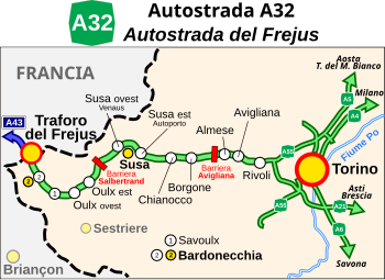
| map | |||||||||||||||||||||||||||||||||||||||||||||||||||||||||||||||||||||||||||||||||||||||||||||||||||||||||||||||||||||||||||||||||||||||||||||||||||||||||||||||||||||||||||||||||||||||||||||||||||||||||||||||||||||||||||||||||||||||||||||||||||||||||||||||||||||||||
| Basic data | |||||||||||||||||||||||||||||||||||||||||||||||||||||||||||||||||||||||||||||||||||||||||||||||||||||||||||||||||||||||||||||||||||||||||||||||||||||||||||||||||||||||||||||||||||||||||||||||||||||||||||||||||||||||||||||||||||||||||||||||||||||||||||||||||||||||||
| Operator: | |||||||||||||||||||||||||||||||||||||||||||||||||||||||||||||||||||||||||||||||||||||||||||||||||||||||||||||||||||||||||||||||||||||||||||||||||||||||||||||||||||||||||||||||||||||||||||||||||||||||||||||||||||||||||||||||||||||||||||||||||||||||||||||||||||||||||
| Start of the street: |
Rivoli ( 45 ° 5 ′ N , 7 ° 30 ′ E ) |
||||||||||||||||||||||||||||||||||||||||||||||||||||||||||||||||||||||||||||||||||||||||||||||||||||||||||||||||||||||||||||||||||||||||||||||||||||||||||||||||||||||||||||||||||||||||||||||||||||||||||||||||||||||||||||||||||||||||||||||||||||||||||||||||||||||||
| End of street: |
Bardonecchia ( 45 ° 5 ′ N , 6 ° 43 ′ E ) |
||||||||||||||||||||||||||||||||||||||||||||||||||||||||||||||||||||||||||||||||||||||||||||||||||||||||||||||||||||||||||||||||||||||||||||||||||||||||||||||||||||||||||||||||||||||||||||||||||||||||||||||||||||||||||||||||||||||||||||||||||||||||||||||||||||||||
| Overall length: | 73 km | ||||||||||||||||||||||||||||||||||||||||||||||||||||||||||||||||||||||||||||||||||||||||||||||||||||||||||||||||||||||||||||||||||||||||||||||||||||||||||||||||||||||||||||||||||||||||||||||||||||||||||||||||||||||||||||||||||||||||||||||||||||||||||||||||||||||||
|
Regions : |
|||||||||||||||||||||||||||||||||||||||||||||||||||||||||||||||||||||||||||||||||||||||||||||||||||||||||||||||||||||||||||||||||||||||||||||||||||||||||||||||||||||||||||||||||||||||||||||||||||||||||||||||||||||||||||||||||||||||||||||||||||||||||||||||||||||||||
| Requirement for use: | Toll obligation: open system | ||||||||||||||||||||||||||||||||||||||||||||||||||||||||||||||||||||||||||||||||||||||||||||||||||||||||||||||||||||||||||||||||||||||||||||||||||||||||||||||||||||||||||||||||||||||||||||||||||||||||||||||||||||||||||||||||||||||||||||||||||||||||||||||||||||||||
| Development condition: | 2 × 1 and 2 × 2 lanes | ||||||||||||||||||||||||||||||||||||||||||||||||||||||||||||||||||||||||||||||||||||||||||||||||||||||||||||||||||||||||||||||||||||||||||||||||||||||||||||||||||||||||||||||||||||||||||||||||||||||||||||||||||||||||||||||||||||||||||||||||||||||||||||||||||||||||
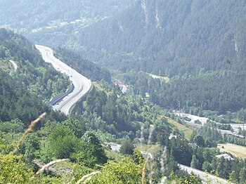
| View of the A32 between Savoulx and Bardonecchia | |||||||||||||||||||||||||||||||||||||||||||||||||||||||||||||||||||||||||||||||||||||||||||||||||||||||||||||||||||||||||||||||||||||||||||||||||||||||||||||||||||||||||||||||||||||||||||||||||||||||||||||||||||||||||||||||||||||||||||||||||||||||||||||||||||||||||
|
Course of the road
|
|||||||||||||||||||||||||||||||||||||||||||||||||||||||||||||||||||||||||||||||||||||||||||||||||||||||||||||||||||||||||||||||||||||||||||||||||||||||||||||||||||||||||||||||||||||||||||||||||||||||||||||||||||||||||||||||||||||||||||||||||||||||||||||||||||||||||
The Autostrada A32 ( Italian for 'Motorway A32'), also known as Autostrada del Frejus , is an Italian motorway in the north-west of the country that runs from Turin to the Fréjus Tunnel on the border with France . It is 73 km long and tolls between Oulx est and Almese .
course
The A32 connects the city of Turin and thus also the economic region of the Po Valley with France and Lyon . Besides the A5, it is the only motorway that crosses the Alps to France and is therefore very important.
The centerpiece is the Mont-Cenis-Tunnel (also called Fréjus-Tunnel). However, this is classified as a separate tunnel motorway T4 ( Traforo stradale del Frejus ).
It runs through the Val di Susa and leads along the highest mountains in the Alps .
The A32 begins in Turin, where it branches off from the Turin city bypass (Italian: Tangenziale). At Avigliana it reaches the Alps and follows the Dora Riparia river past the towns of Condove , Borgone Susa , Susa and Oulx . At Bardonecchia the A32 ends directly at the Frejus tunnel .
In France, the motorway continues as the A43 autoroute .
State of development
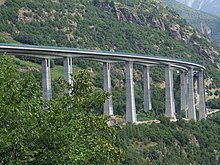
The total length of the motorway is 73 km, of which 19 km are on bridges and 18 km in tunnels . The route has four lanes throughout and has 3 rest stops.
Due to the mountain location, the A32 has several tunnels, the longest being the Cels with a length of 5,241 meters.
Many connection points are only developed as half connection points . It is therefore only possible to drive up or down in one direction.
administration
The motorway between Rivoli and the entrance to the Frejus tunnel is managed by the Italian motorway company SITAF ( Società Italiana per il Traforo Autostradale del Frejus ).
toll
The A32 is subject to a toll, but unlike most motorways, it has a different toll system . The amount of the toll is usually determined by the distance traveled and the road used and the vehicle class. The toll is paid in motorway stations when leaving the motorway.
However, this highway is managed as an open system , i.e. H. At the two toll stations, regardless of the distance covered, only a lump sum is charged; By bypassing the two toll stations, most of the motorway can be used free of charge.
→ see also: Tolls in Italy
history
Construction work on the A32 began in the 1980s.
The first section with a total length of 21 km between Bardonecchia and Deveys was opened on October 15, 1987. This section was built by ANAS .
In 1990 the line between Turin - Avigliana (01.12) and between Borgone - Bussoleno (02.06), followed in 1992 by the section between Deveys and Susa and the line between Avigliana and Borgone.
The last section between Bussoleno and Susa was opened on July 7, 1995.


