Raccordo autostradale 15
| Raccordo autostradale RA15 in Italy | |||||||||||||||||||||||||||||||||||||||||||||||||||||||||||||||||||||||||||||||||||||||||||||||||||||||||||||||||||||||||
| Tangenziale di Catania (Tangent Catania) |
|||||||||||||||||||||||||||||||||||||||||||||||||||||||||||||||||||||||||||||||||||||||||||||||||||||||||||||||||||||||||

|
|||||||||||||||||||||||||||||||||||||||||||||||||||||||||||||||||||||||||||||||||||||||||||||||||||||||||||||||||||||||||
| |
|||||||||||||||||||||||||||||||||||||||||||||||||||||||||||||||||||||||||||||||||||||||||||||||||||||||||||||||||||||||||
| map | |||||||||||||||||||||||||||||||||||||||||||||||||||||||||||||||||||||||||||||||||||||||||||||||||||||||||||||||||||||||||
| Basic data | |||||||||||||||||||||||||||||||||||||||||||||||||||||||||||||||||||||||||||||||||||||||||||||||||||||||||||||||||||||||||
| Operator: | |||||||||||||||||||||||||||||||||||||||||||||||||||||||||||||||||||||||||||||||||||||||||||||||||||||||||||||||||||||||||
| Start of the street: |
San Giovanni la Punta / San Gregorio di Catania ( 37 ° 34 ′ N , 15 ° 6 ′ E ) |
||||||||||||||||||||||||||||||||||||||||||||||||||||||||||||||||||||||||||||||||||||||||||||||||||||||||||||||||||||||||
| End of street: |
Catania ( 37 ° 25 ′ N , 15 ° 4 ′ E ) |
||||||||||||||||||||||||||||||||||||||||||||||||||||||||||||||||||||||||||||||||||||||||||||||||||||||||||||||||||||||||
| Overall length: | 24 km | ||||||||||||||||||||||||||||||||||||||||||||||||||||||||||||||||||||||||||||||||||||||||||||||||||||||||||||||||||||||||
|
Regions : |
|||||||||||||||||||||||||||||||||||||||||||||||||||||||||||||||||||||||||||||||||||||||||||||||||||||||||||||||||||||||||
| Requirement for use: | toll-free | ||||||||||||||||||||||||||||||||||||||||||||||||||||||||||||||||||||||||||||||||||||||||||||||||||||||||||||||||||||||||
| Development condition: | 2 × 2 lanes | ||||||||||||||||||||||||||||||||||||||||||||||||||||||||||||||||||||||||||||||||||||||||||||||||||||||||||||||||||||||||
|
Course of the road
|
|||||||||||||||||||||||||||||||||||||||||||||||||||||||||||||||||||||||||||||||||||||||||||||||||||||||||||||||||||||||||
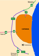
The Raccordo autostradale 15 ( Italian for 'motorway feeder 15'), also known as Tangenziale di Catania (Tangente von Catania) , is a motorway feeder near the Sicilian city of Catania . It is located in the Italian region of Sicily .
The Decreto Legislativo 29 ottobre 1999, n.461 did not include the RA15 in the Italian motorway network, but classified it as a road of national interest . The 24 km long motorway slip road is managed by ANAS . It was opened in 1985.
The route is part of the E 45 .
Meaning and course
The 23 km long motorway slip road connects three Sicilian motorways. It starts on the A18 ( Messina - Catania ). At kilometer 15 the A19 branches off , which leads to the capital of Sicily, Palermo . The Autostrada Catania-Siracusa branches off at kilometer 19 .
In the south the RA15 merges into the SS 114.
So far, the RA 15, like all routes managed by ANAS, has been toll-free.


