Autostrada A56
| Autostrada A56 in Italy | |||||||||||||||||||||||||||||||||||||||||||||||||||||||||||||||||||||||||||||||||||||||||||||||||||||||||||||||||||||||||||||||||||||||||||||||||||||||
| Tangenziale di Napoli (Tangent Naples) |
|||||||||||||||||||||||||||||||||||||||||||||||||||||||||||||||||||||||||||||||||||||||||||||||||||||||||||||||||||||||||||||||||||||||||||||||||||||||

|
|||||||||||||||||||||||||||||||||||||||||||||||||||||||||||||||||||||||||||||||||||||||||||||||||||||||||||||||||||||||||||||||||||||||||||||||||||||||
| map | |||||||||||||||||||||||||||||||||||||||||||||||||||||||||||||||||||||||||||||||||||||||||||||||||||||||||||||||||||||||||||||||||||||||||||||||||||||||
| Basic data | |||||||||||||||||||||||||||||||||||||||||||||||||||||||||||||||||||||||||||||||||||||||||||||||||||||||||||||||||||||||||||||||||||||||||||||||||||||||
| Operator: | |||||||||||||||||||||||||||||||||||||||||||||||||||||||||||||||||||||||||||||||||||||||||||||||||||||||||||||||||||||||||||||||||||||||||||||||||||||||
| Start of the street: |
Naples ( 40 ° 53 ′ N , 14 ° 17 ′ E ) |
||||||||||||||||||||||||||||||||||||||||||||||||||||||||||||||||||||||||||||||||||||||||||||||||||||||||||||||||||||||||||||||||||||||||||||||||||||||
| End of street: |
Pozzuoli ( 40 ° 51 ′ N , 14 ° 5 ′ E ) |
||||||||||||||||||||||||||||||||||||||||||||||||||||||||||||||||||||||||||||||||||||||||||||||||||||||||||||||||||||||||||||||||||||||||||||||||||||||
| Overall length: | 20.2 km | ||||||||||||||||||||||||||||||||||||||||||||||||||||||||||||||||||||||||||||||||||||||||||||||||||||||||||||||||||||||||||||||||||||||||||||||||||||||
|
Regions : |
|||||||||||||||||||||||||||||||||||||||||||||||||||||||||||||||||||||||||||||||||||||||||||||||||||||||||||||||||||||||||||||||||||||||||||||||||||||||
| Requirement for use: | Toll obligation: open system | ||||||||||||||||||||||||||||||||||||||||||||||||||||||||||||||||||||||||||||||||||||||||||||||||||||||||||||||||||||||||||||||||||||||||||||||||||||||
| Development condition: | 2 × 2 and 2 × 3 lanes | ||||||||||||||||||||||||||||||||||||||||||||||||||||||||||||||||||||||||||||||||||||||||||||||||||||||||||||||||||||||||||||||||||||||||||||||||||||||
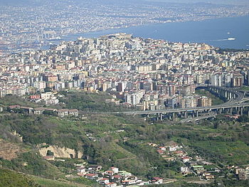
| View of the Tangent of Naples at the Arena Sant'Antonio bridge | |||||||||||||||||||||||||||||||||||||||||||||||||||||||||||||||||||||||||||||||||||||||||||||||||||||||||||||||||||||||||||||||||||||||||||||||||||||||
|
Course of the road
|
|||||||||||||||||||||||||||||||||||||||||||||||||||||||||||||||||||||||||||||||||||||||||||||||||||||||||||||||||||||||||||||||||||||||||||||||||||||||
The Autostrada A56 ( Italian for, highway A56 '), also Tangenziale di Napoli (tangent of Naples) called, is the motorway bypass of Naples . It is 21 km long, has six lanes , but mostly without hard shoulder , and tolls . It is supposed to relieve the inner city of Naples and take up the transit traffic from the city.
history
The infrastructure project started on January 31, 1968. The basis was the agreement between ANAS and Infrasud, a subsidiary of the IRI group Italstat at the time and today's Tangenziale di Napoli SpA, as well as the signing of a 33-year contract which covers the construction and regulated the operation of the route. The project was funded 70% directly by IRI, 15% by Società Meridionale di Elettricità, which was also part of IRI at the time, and 15% by Banco di Napoli .
The first section was opened on July 8, 1972 between Pozzuoli and Fuorigrotta , followed by the line to Capodichino on November 16, 1975. The openings of the interchanges Corso Malta and Capodimonte in 1976 and 1977 followed.
Toll and operator
The current operator of the motorway is Tangenziale di Napoli SpA, a subsidiary of Atlantia . Depending on the number of axles in the vehicle, the toll fee per trip is between EUR 1.00 and EUR 3.90. The revenue from the toll is around 6 million euros per month, with an average of 233,646 vehicles using the A56 every day in 2017.
Engineering structures and course
There are 3,191 m bridges along the A56, which is 15.8% of the total length. In total there are eight viaducts, which are listed in the following table with increasing length:
|
A56 Tangenziale di Napoli bridges |
||
| Surname | length | Others |
|---|---|---|
| Domitiana | 56 m | |
| Calata San Domenico | 160 m | |
| Via Campana | 190 m | |
| Miano-Agnano | 190 m | |
| Cassiodoro | 193 m | |
| Fontanel | 230 m | |
| Arena Sant'Antonio | 812 m | |
| Capodichino | 1360 m | Maximum height 60 m |
Due to the hilly terrain around Naples, some tunnels were also necessary. Its total length is 3,775 meters and a share of 19.7% of the total length of the A56. There are also four rockfall protection galleries in the direction of Pozzuoli .
See also
Individual evidence
- ↑ Tariff overview (as of January 1, 2018) on the operator's website Tangenziale di Napoli SpA, accessed on August 17, 2018
- ↑ Relazione sulla Gestione e Bilancio dell'esercizio chiuso al 31 December 2017 . Company balance sheet. Tangenziale di Napoli SpA, March 27, 2018, p. 18 (Italian, 95.110.233.137 [ ZIP ; 604 kB ; accessed on August 17, 2018]).


