Autostrada A28
| Autostrada A28 in Italy | ||||||||||||||||||||||||||||||||||||||||||||||||||||||||||||||||||||||||||||||||||||||||||||||||||||||||||||||||||||||||||||||||||||||||||||||||||||
| Autostrada Portogruaro - Pordenone - Conegliano | ||||||||||||||||||||||||||||||||||||||||||||||||||||||||||||||||||||||||||||||||||||||||||||||||||||||||||||||||||||||||||||||||||||||||||||||||||||

|
||||||||||||||||||||||||||||||||||||||||||||||||||||||||||||||||||||||||||||||||||||||||||||||||||||||||||||||||||||||||||||||||||||||||||||||||||||
| map | ||||||||||||||||||||||||||||||||||||||||||||||||||||||||||||||||||||||||||||||||||||||||||||||||||||||||||||||||||||||||||||||||||||||||||||||||||||
| Basic data | ||||||||||||||||||||||||||||||||||||||||||||||||||||||||||||||||||||||||||||||||||||||||||||||||||||||||||||||||||||||||||||||||||||||||||||||||||||
| Operator: | ||||||||||||||||||||||||||||||||||||||||||||||||||||||||||||||||||||||||||||||||||||||||||||||||||||||||||||||||||||||||||||||||||||||||||||||||||||
| Start of the street: |
Portogruaro ( 45 ° 48 ′ N , 12 ° 50 ′ E ) |
|||||||||||||||||||||||||||||||||||||||||||||||||||||||||||||||||||||||||||||||||||||||||||||||||||||||||||||||||||||||||||||||||||||||||||||||||||
| End of street: |
San Vendemiano ( 45 ° 53 ′ N , 12 ° 20 ′ E ) |
|||||||||||||||||||||||||||||||||||||||||||||||||||||||||||||||||||||||||||||||||||||||||||||||||||||||||||||||||||||||||||||||||||||||||||||||||||
| Overall length: | 48.7 km | |||||||||||||||||||||||||||||||||||||||||||||||||||||||||||||||||||||||||||||||||||||||||||||||||||||||||||||||||||||||||||||||||||||||||||||||||||
|
Regions : |
||||||||||||||||||||||||||||||||||||||||||||||||||||||||||||||||||||||||||||||||||||||||||||||||||||||||||||||||||||||||||||||||||||||||||||||||||||
| Requirement for use: | Toll obligation: closed system : on the Conegliano - Sacile ovest section Toll-free : on the Portogruaro - Sacile ovest section |
|||||||||||||||||||||||||||||||||||||||||||||||||||||||||||||||||||||||||||||||||||||||||||||||||||||||||||||||||||||||||||||||||||||||||||||||||||
| Development condition: | 2 × 2 lanes | |||||||||||||||||||||||||||||||||||||||||||||||||||||||||||||||||||||||||||||||||||||||||||||||||||||||||||||||||||||||||||||||||||||||||||||||||||
| The A28 between the Godega di SU and Sacile ovest junctions | ||||||||||||||||||||||||||||||||||||||||||||||||||||||||||||||||||||||||||||||||||||||||||||||||||||||||||||||||||||||||||||||||||||||||||||||||||||
|
Course of the road
|
||||||||||||||||||||||||||||||||||||||||||||||||||||||||||||||||||||||||||||||||||||||||||||||||||||||||||||||||||||||||||||||||||||||||||||||||||||
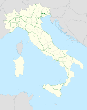
The Autostrada A28 ( Italian for 'Autobahn A28') is an Italian motorway in the north of the country . It is located in the Friuli-Venezia Giulia and Veneto regions and runs from Portogruaro to Conegliano.
Route
The motorway branches off from the A4 in Veneto near the city of Portogruaro and heads north to Friuli-Venezia Giulia. Passing Azzano Decimo , she reaches the provincial capital Pordenone . At the junction Cimpello the branches feeder road RA16 from. This is the beginning of a planned motorway that connects the A28 with the A23 at Gemona del Friuli .
Then it continues eastwards past Sacile , where it re-enters the Veneto. Passing Godega Sant'Urbano, it joins the A27 in Conegliano .
History and meaning
The A28 primarily connects the industrial city of Pordenone to the motorway network. Furthermore, by connecting to the A27, the Belluno - Trieste route is significantly shortened , as Venice is bypassed to the north.
The section between Portogruaro and Pordenone, which makes up the majority of the route, was opened on December 31, 1974. Further extensions followed in 1992 (Pordenone – Fontanafredda), 1994 (Fontanafredda – Sacile), 1996 (Sacile Est - Ovest) and 2006 to Godega Sant'Urbano.
Connection to the A27
The connection to the A27 near Conegliano was originally planned for summer 2010.
On July 30, 2010, the A28 between Portogruaro and Conegliano was opened with restrictions. Between July 30th and October 23rd, 2010 the motorway was only open between Friday 2pm and Sunday 10pm. The aim was to relieve the completely congested A4 between Portogruaro and Venice, as there was an increased volume of traffic to the seaside resorts on the Adriatic coast , especially on weekends . At the Passante di Mestre (A4), traffic will be diverted via the A27 and A28 in order to be returned to the A4 at Portogruaro . In the direction of Conegliano, the A28 was open - as before - up to the Sacile Ovest junction.
Originally, the motorway was supposed to be completely opened much earlier. The reason for the decades of delays were disputes between environmentalists and project supporters. In its section, the A28 crosses several so-called Palù (natural, small streams).
The last section of the A28 opened at 3 p.m. on October 23, 2010. This ends the 38 year long controversy between environmentalists and those in favor of the Autobahn.
Web links
Individual evidence
- ^ Structures along the A28
- ↑ Opening dates of the A28
- ↑ Apertura temporanea A28 Portogruaro Conegliano ( Memento from August 2, 2010 in the Internet Archive ), Autovie Venete newsletter of August 6, 2010, accessed on August 6, 2010 (Italian).
- ↑ Demolizione Fuenti “Un 'Idea Meravigliosa”, Dice Il Wwf . Yepa.com. Retrieved July 2, 2010.
- ^ A28 Aperto , report by la tribuna , Treviso of October 23, 2010


