Autostrada A12 (Italy)
| Autostrada A12 in Italy | |||||||||||||||||||||||||||||||||||||||||||||||||||||||||||||||||||||||||||||||||||||||||||||||||||||||||||||||||||||||||||||||||||||||||||||||||||||||||||||||||||||||||||||||||||||||||||||||||||||||||||||||||||||||||||||||||||||||||||||||||||||||||||||||||||||||||||||||||||||||||||||||||||||||||||||||||||||||||||||||||||||||||||||||||||||||||||||||||||||||||||||||||||||||||||||||||||||||||||||||||||||||||||||||||||||||||||||||||||||||||||||||||||||||||||||||||||||||||||||||||||||||||||||||||||||||||||||||||||||||||||||||||||||||||||||||||||||||||||||||||||||||||||||||||||||||||||||||||||||||||||||||||||||||||||||||||||||||||||||||||||||||||||||||||||||||||||||||||||||||||||||||||||||||||||||||||||||||||||||||||||||||||||||||||||||||||||||||||||||||||||||||||||||||||||||||||||||||||||||||||||||||||||||||||||||||||||||||||||||||||||||||||||||||||||||||||||||||||||||||||||||||||||||||||||||||||||||||||||||||||||||||||||||||||||||||||||||||||||||||||||||||||||||||||||
|
Autostrada Azzurra Genova - Roma |
|||||||||||||||||||||||||||||||||||||||||||||||||||||||||||||||||||||||||||||||||||||||||||||||||||||||||||||||||||||||||||||||||||||||||||||||||||||||||||||||||||||||||||||||||||||||||||||||||||||||||||||||||||||||||||||||||||||||||||||||||||||||||||||||||||||||||||||||||||||||||||||||||||||||||||||||||||||||||||||||||||||||||||||||||||||||||||||||||||||||||||||||||||||||||||||||||||||||||||||||||||||||||||||||||||||||||||||||||||||||||||||||||||||||||||||||||||||||||||||||||||||||||||||||||||||||||||||||||||||||||||||||||||||||||||||||||||||||||||||||||||||||||||||||||||||||||||||||||||||||||||||||||||||||||||||||||||||||||||||||||||||||||||||||||||||||||||||||||||||||||||||||||||||||||||||||||||||||||||||||||||||||||||||||||||||||||||||||||||||||||||||||||||||||||||||||||||||||||||||||||||||||||||||||||||||||||||||||||||||||||||||||||||||||||||||||||||||||||||||||||||||||||||||||||||||||||||||||||||||||||||||||||||||||||||||||||||||||||||||||||||||||||||||||||||

|
|||||||||||||||||||||||||||||||||||||||||||||||||||||||||||||||||||||||||||||||||||||||||||||||||||||||||||||||||||||||||||||||||||||||||||||||||||||||||||||||||||||||||||||||||||||||||||||||||||||||||||||||||||||||||||||||||||||||||||||||||||||||||||||||||||||||||||||||||||||||||||||||||||||||||||||||||||||||||||||||||||||||||||||||||||||||||||||||||||||||||||||||||||||||||||||||||||||||||||||||||||||||||||||||||||||||||||||||||||||||||||||||||||||||||||||||||||||||||||||||||||||||||||||||||||||||||||||||||||||||||||||||||||||||||||||||||||||||||||||||||||||||||||||||||||||||||||||||||||||||||||||||||||||||||||||||||||||||||||||||||||||||||||||||||||||||||||||||||||||||||||||||||||||||||||||||||||||||||||||||||||||||||||||||||||||||||||||||||||||||||||||||||||||||||||||||||||||||||||||||||||||||||||||||||||||||||||||||||||||||||||||||||||||||||||||||||||||||||||||||||||||||||||||||||||||||||||||||||||||||||||||||||||||||||||||||||||||||||||||||||||||||||||||||||||
| |
|||||||||||||||||||||||||||||||||||||||||||||||||||||||||||||||||||||||||||||||||||||||||||||||||||||||||||||||||||||||||||||||||||||||||||||||||||||||||||||||||||||||||||||||||||||||||||||||||||||||||||||||||||||||||||||||||||||||||||||||||||||||||||||||||||||||||||||||||||||||||||||||||||||||||||||||||||||||||||||||||||||||||||||||||||||||||||||||||||||||||||||||||||||||||||||||||||||||||||||||||||||||||||||||||||||||||||||||||||||||||||||||||||||||||||||||||||||||||||||||||||||||||||||||||||||||||||||||||||||||||||||||||||||||||||||||||||||||||||||||||||||||||||||||||||||||||||||||||||||||||||||||||||||||||||||||||||||||||||||||||||||||||||||||||||||||||||||||||||||||||||||||||||||||||||||||||||||||||||||||||||||||||||||||||||||||||||||||||||||||||||||||||||||||||||||||||||||||||||||||||||||||||||||||||||||||||||||||||||||||||||||||||||||||||||||||||||||||||||||||||||||||||||||||||||||||||||||||||||||||||||||||||||||||||||||||||||||||||||||||||||||||||||||||||||
| map | |||||||||||||||||||||||||||||||||||||||||||||||||||||||||||||||||||||||||||||||||||||||||||||||||||||||||||||||||||||||||||||||||||||||||||||||||||||||||||||||||||||||||||||||||||||||||||||||||||||||||||||||||||||||||||||||||||||||||||||||||||||||||||||||||||||||||||||||||||||||||||||||||||||||||||||||||||||||||||||||||||||||||||||||||||||||||||||||||||||||||||||||||||||||||||||||||||||||||||||||||||||||||||||||||||||||||||||||||||||||||||||||||||||||||||||||||||||||||||||||||||||||||||||||||||||||||||||||||||||||||||||||||||||||||||||||||||||||||||||||||||||||||||||||||||||||||||||||||||||||||||||||||||||||||||||||||||||||||||||||||||||||||||||||||||||||||||||||||||||||||||||||||||||||||||||||||||||||||||||||||||||||||||||||||||||||||||||||||||||||||||||||||||||||||||||||||||||||||||||||||||||||||||||||||||||||||||||||||||||||||||||||||||||||||||||||||||||||||||||||||||||||||||||||||||||||||||||||||||||||||||||||||||||||||||||||||||||||||||||||||||||||||||||||||||
| Basic data | |||||||||||||||||||||||||||||||||||||||||||||||||||||||||||||||||||||||||||||||||||||||||||||||||||||||||||||||||||||||||||||||||||||||||||||||||||||||||||||||||||||||||||||||||||||||||||||||||||||||||||||||||||||||||||||||||||||||||||||||||||||||||||||||||||||||||||||||||||||||||||||||||||||||||||||||||||||||||||||||||||||||||||||||||||||||||||||||||||||||||||||||||||||||||||||||||||||||||||||||||||||||||||||||||||||||||||||||||||||||||||||||||||||||||||||||||||||||||||||||||||||||||||||||||||||||||||||||||||||||||||||||||||||||||||||||||||||||||||||||||||||||||||||||||||||||||||||||||||||||||||||||||||||||||||||||||||||||||||||||||||||||||||||||||||||||||||||||||||||||||||||||||||||||||||||||||||||||||||||||||||||||||||||||||||||||||||||||||||||||||||||||||||||||||||||||||||||||||||||||||||||||||||||||||||||||||||||||||||||||||||||||||||||||||||||||||||||||||||||||||||||||||||||||||||||||||||||||||||||||||||||||||||||||||||||||||||||||||||||||||||||||||||||||||||
| Operator: | |||||||||||||||||||||||||||||||||||||||||||||||||||||||||||||||||||||||||||||||||||||||||||||||||||||||||||||||||||||||||||||||||||||||||||||||||||||||||||||||||||||||||||||||||||||||||||||||||||||||||||||||||||||||||||||||||||||||||||||||||||||||||||||||||||||||||||||||||||||||||||||||||||||||||||||||||||||||||||||||||||||||||||||||||||||||||||||||||||||||||||||||||||||||||||||||||||||||||||||||||||||||||||||||||||||||||||||||||||||||||||||||||||||||||||||||||||||||||||||||||||||||||||||||||||||||||||||||||||||||||||||||||||||||||||||||||||||||||||||||||||||||||||||||||||||||||||||||||||||||||||||||||||||||||||||||||||||||||||||||||||||||||||||||||||||||||||||||||||||||||||||||||||||||||||||||||||||||||||||||||||||||||||||||||||||||||||||||||||||||||||||||||||||||||||||||||||||||||||||||||||||||||||||||||||||||||||||||||||||||||||||||||||||||||||||||||||||||||||||||||||||||||||||||||||||||||||||||||||||||||||||||||||||||||||||||||||||||||||||||||||||||||||||||||||
| Start of the street: |
Genoa ( 44 ° 27 ′ N , 8 ° 54 ′ E ) |
||||||||||||||||||||||||||||||||||||||||||||||||||||||||||||||||||||||||||||||||||||||||||||||||||||||||||||||||||||||||||||||||||||||||||||||||||||||||||||||||||||||||||||||||||||||||||||||||||||||||||||||||||||||||||||||||||||||||||||||||||||||||||||||||||||||||||||||||||||||||||||||||||||||||||||||||||||||||||||||||||||||||||||||||||||||||||||||||||||||||||||||||||||||||||||||||||||||||||||||||||||||||||||||||||||||||||||||||||||||||||||||||||||||||||||||||||||||||||||||||||||||||||||||||||||||||||||||||||||||||||||||||||||||||||||||||||||||||||||||||||||||||||||||||||||||||||||||||||||||||||||||||||||||||||||||||||||||||||||||||||||||||||||||||||||||||||||||||||||||||||||||||||||||||||||||||||||||||||||||||||||||||||||||||||||||||||||||||||||||||||||||||||||||||||||||||||||||||||||||||||||||||||||||||||||||||||||||||||||||||||||||||||||||||||||||||||||||||||||||||||||||||||||||||||||||||||||||||||||||||||||||||||||||||||||||||||||||||||||||||||||||||||||||||||
| End of street: |
Rome / Fiumicino ( 41 ° 49 ′ N , 12 ° 18 ′ E ) |
||||||||||||||||||||||||||||||||||||||||||||||||||||||||||||||||||||||||||||||||||||||||||||||||||||||||||||||||||||||||||||||||||||||||||||||||||||||||||||||||||||||||||||||||||||||||||||||||||||||||||||||||||||||||||||||||||||||||||||||||||||||||||||||||||||||||||||||||||||||||||||||||||||||||||||||||||||||||||||||||||||||||||||||||||||||||||||||||||||||||||||||||||||||||||||||||||||||||||||||||||||||||||||||||||||||||||||||||||||||||||||||||||||||||||||||||||||||||||||||||||||||||||||||||||||||||||||||||||||||||||||||||||||||||||||||||||||||||||||||||||||||||||||||||||||||||||||||||||||||||||||||||||||||||||||||||||||||||||||||||||||||||||||||||||||||||||||||||||||||||||||||||||||||||||||||||||||||||||||||||||||||||||||||||||||||||||||||||||||||||||||||||||||||||||||||||||||||||||||||||||||||||||||||||||||||||||||||||||||||||||||||||||||||||||||||||||||||||||||||||||||||||||||||||||||||||||||||||||||||||||||||||||||||||||||||||||||||||||||||||||||||||||||||||||
| Overall length: | 477.2 km | ||||||||||||||||||||||||||||||||||||||||||||||||||||||||||||||||||||||||||||||||||||||||||||||||||||||||||||||||||||||||||||||||||||||||||||||||||||||||||||||||||||||||||||||||||||||||||||||||||||||||||||||||||||||||||||||||||||||||||||||||||||||||||||||||||||||||||||||||||||||||||||||||||||||||||||||||||||||||||||||||||||||||||||||||||||||||||||||||||||||||||||||||||||||||||||||||||||||||||||||||||||||||||||||||||||||||||||||||||||||||||||||||||||||||||||||||||||||||||||||||||||||||||||||||||||||||||||||||||||||||||||||||||||||||||||||||||||||||||||||||||||||||||||||||||||||||||||||||||||||||||||||||||||||||||||||||||||||||||||||||||||||||||||||||||||||||||||||||||||||||||||||||||||||||||||||||||||||||||||||||||||||||||||||||||||||||||||||||||||||||||||||||||||||||||||||||||||||||||||||||||||||||||||||||||||||||||||||||||||||||||||||||||||||||||||||||||||||||||||||||||||||||||||||||||||||||||||||||||||||||||||||||||||||||||||||||||||||||||||||||||||||||||||||||||
| of which in operation: | 290 km | ||||||||||||||||||||||||||||||||||||||||||||||||||||||||||||||||||||||||||||||||||||||||||||||||||||||||||||||||||||||||||||||||||||||||||||||||||||||||||||||||||||||||||||||||||||||||||||||||||||||||||||||||||||||||||||||||||||||||||||||||||||||||||||||||||||||||||||||||||||||||||||||||||||||||||||||||||||||||||||||||||||||||||||||||||||||||||||||||||||||||||||||||||||||||||||||||||||||||||||||||||||||||||||||||||||||||||||||||||||||||||||||||||||||||||||||||||||||||||||||||||||||||||||||||||||||||||||||||||||||||||||||||||||||||||||||||||||||||||||||||||||||||||||||||||||||||||||||||||||||||||||||||||||||||||||||||||||||||||||||||||||||||||||||||||||||||||||||||||||||||||||||||||||||||||||||||||||||||||||||||||||||||||||||||||||||||||||||||||||||||||||||||||||||||||||||||||||||||||||||||||||||||||||||||||||||||||||||||||||||||||||||||||||||||||||||||||||||||||||||||||||||||||||||||||||||||||||||||||||||||||||||||||||||||||||||||||||||||||||||||||||||||||||||||||
| of which in planning: | 187.5 km | ||||||||||||||||||||||||||||||||||||||||||||||||||||||||||||||||||||||||||||||||||||||||||||||||||||||||||||||||||||||||||||||||||||||||||||||||||||||||||||||||||||||||||||||||||||||||||||||||||||||||||||||||||||||||||||||||||||||||||||||||||||||||||||||||||||||||||||||||||||||||||||||||||||||||||||||||||||||||||||||||||||||||||||||||||||||||||||||||||||||||||||||||||||||||||||||||||||||||||||||||||||||||||||||||||||||||||||||||||||||||||||||||||||||||||||||||||||||||||||||||||||||||||||||||||||||||||||||||||||||||||||||||||||||||||||||||||||||||||||||||||||||||||||||||||||||||||||||||||||||||||||||||||||||||||||||||||||||||||||||||||||||||||||||||||||||||||||||||||||||||||||||||||||||||||||||||||||||||||||||||||||||||||||||||||||||||||||||||||||||||||||||||||||||||||||||||||||||||||||||||||||||||||||||||||||||||||||||||||||||||||||||||||||||||||||||||||||||||||||||||||||||||||||||||||||||||||||||||||||||||||||||||||||||||||||||||||||||||||||||||||||||||||||||||||
|
Regions : |
|||||||||||||||||||||||||||||||||||||||||||||||||||||||||||||||||||||||||||||||||||||||||||||||||||||||||||||||||||||||||||||||||||||||||||||||||||||||||||||||||||||||||||||||||||||||||||||||||||||||||||||||||||||||||||||||||||||||||||||||||||||||||||||||||||||||||||||||||||||||||||||||||||||||||||||||||||||||||||||||||||||||||||||||||||||||||||||||||||||||||||||||||||||||||||||||||||||||||||||||||||||||||||||||||||||||||||||||||||||||||||||||||||||||||||||||||||||||||||||||||||||||||||||||||||||||||||||||||||||||||||||||||||||||||||||||||||||||||||||||||||||||||||||||||||||||||||||||||||||||||||||||||||||||||||||||||||||||||||||||||||||||||||||||||||||||||||||||||||||||||||||||||||||||||||||||||||||||||||||||||||||||||||||||||||||||||||||||||||||||||||||||||||||||||||||||||||||||||||||||||||||||||||||||||||||||||||||||||||||||||||||||||||||||||||||||||||||||||||||||||||||||||||||||||||||||||||||||||||||||||||||||||||||||||||||||||||||||||||||||||||||||||||||||||||
| Requirement for use: | Toll obligation: closed system on the Genoa - San Pietro in Palazzi section . Toll obligation: open system on the Tarquinia section - node A91 |
||||||||||||||||||||||||||||||||||||||||||||||||||||||||||||||||||||||||||||||||||||||||||||||||||||||||||||||||||||||||||||||||||||||||||||||||||||||||||||||||||||||||||||||||||||||||||||||||||||||||||||||||||||||||||||||||||||||||||||||||||||||||||||||||||||||||||||||||||||||||||||||||||||||||||||||||||||||||||||||||||||||||||||||||||||||||||||||||||||||||||||||||||||||||||||||||||||||||||||||||||||||||||||||||||||||||||||||||||||||||||||||||||||||||||||||||||||||||||||||||||||||||||||||||||||||||||||||||||||||||||||||||||||||||||||||||||||||||||||||||||||||||||||||||||||||||||||||||||||||||||||||||||||||||||||||||||||||||||||||||||||||||||||||||||||||||||||||||||||||||||||||||||||||||||||||||||||||||||||||||||||||||||||||||||||||||||||||||||||||||||||||||||||||||||||||||||||||||||||||||||||||||||||||||||||||||||||||||||||||||||||||||||||||||||||||||||||||||||||||||||||||||||||||||||||||||||||||||||||||||||||||||||||||||||||||||||||||||||||||||||||||||||||||||||
| Development condition: | 2 × 2 lanes | ||||||||||||||||||||||||||||||||||||||||||||||||||||||||||||||||||||||||||||||||||||||||||||||||||||||||||||||||||||||||||||||||||||||||||||||||||||||||||||||||||||||||||||||||||||||||||||||||||||||||||||||||||||||||||||||||||||||||||||||||||||||||||||||||||||||||||||||||||||||||||||||||||||||||||||||||||||||||||||||||||||||||||||||||||||||||||||||||||||||||||||||||||||||||||||||||||||||||||||||||||||||||||||||||||||||||||||||||||||||||||||||||||||||||||||||||||||||||||||||||||||||||||||||||||||||||||||||||||||||||||||||||||||||||||||||||||||||||||||||||||||||||||||||||||||||||||||||||||||||||||||||||||||||||||||||||||||||||||||||||||||||||||||||||||||||||||||||||||||||||||||||||||||||||||||||||||||||||||||||||||||||||||||||||||||||||||||||||||||||||||||||||||||||||||||||||||||||||||||||||||||||||||||||||||||||||||||||||||||||||||||||||||||||||||||||||||||||||||||||||||||||||||||||||||||||||||||||||||||||||||||||||||||||||||||||||||||||||||||||||||||||||||||||||||
| The A12 at the Genova est junction | |||||||||||||||||||||||||||||||||||||||||||||||||||||||||||||||||||||||||||||||||||||||||||||||||||||||||||||||||||||||||||||||||||||||||||||||||||||||||||||||||||||||||||||||||||||||||||||||||||||||||||||||||||||||||||||||||||||||||||||||||||||||||||||||||||||||||||||||||||||||||||||||||||||||||||||||||||||||||||||||||||||||||||||||||||||||||||||||||||||||||||||||||||||||||||||||||||||||||||||||||||||||||||||||||||||||||||||||||||||||||||||||||||||||||||||||||||||||||||||||||||||||||||||||||||||||||||||||||||||||||||||||||||||||||||||||||||||||||||||||||||||||||||||||||||||||||||||||||||||||||||||||||||||||||||||||||||||||||||||||||||||||||||||||||||||||||||||||||||||||||||||||||||||||||||||||||||||||||||||||||||||||||||||||||||||||||||||||||||||||||||||||||||||||||||||||||||||||||||||||||||||||||||||||||||||||||||||||||||||||||||||||||||||||||||||||||||||||||||||||||||||||||||||||||||||||||||||||||||||||||||||||||||||||||||||||||||||||||||||||||||||||||||||||||||
|
Course of the road
|
|||||||||||||||||||||||||||||||||||||||||||||||||||||||||||||||||||||||||||||||||||||||||||||||||||||||||||||||||||||||||||||||||||||||||||||||||||||||||||||||||||||||||||||||||||||||||||||||||||||||||||||||||||||||||||||||||||||||||||||||||||||||||||||||||||||||||||||||||||||||||||||||||||||||||||||||||||||||||||||||||||||||||||||||||||||||||||||||||||||||||||||||||||||||||||||||||||||||||||||||||||||||||||||||||||||||||||||||||||||||||||||||||||||||||||||||||||||||||||||||||||||||||||||||||||||||||||||||||||||||||||||||||||||||||||||||||||||||||||||||||||||||||||||||||||||||||||||||||||||||||||||||||||||||||||||||||||||||||||||||||||||||||||||||||||||||||||||||||||||||||||||||||||||||||||||||||||||||||||||||||||||||||||||||||||||||||||||||||||||||||||||||||||||||||||||||||||||||||||||||||||||||||||||||||||||||||||||||||||||||||||||||||||||||||||||||||||||||||||||||||||||||||||||||||||||||||||||||||||||||||||||||||||||||||||||||||||||||||||||||||||||||||||||||||||
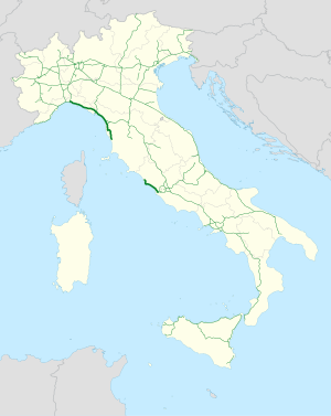
The Autostrada A12 ( Italian for 'Motorway A12'), also called Autostrada Azzurra , is an Italian motorway and connects Genoa with Rome . Between the Cecina - San Pietro in Palazzi and Civitavecchia junctions , the A12 is interrupted for a length of approx. 200 km, but this gap is to be closed in the coming years. The length of the motorway is currently around 271 km. When completed, the motorway will be 477 km long. The entire route of the A12 is subject to a toll and crosses the regions of Liguria , Tuscany and Lazio and is part of European route 80 .
History and course
On its way south along the Tyrrhenian coast and the state road 1 Via Aurelia , the A12 connects to larger cities and important port locations such as La Spezia , Livorno and Civitavecchia . The A12 is also very important for tourism, as it connects holiday destinations such as Carrara , Viareggio , Lucca , Cecina , Rapallo , Recco or Sestri Levante .
The northern section of the A12 Genoa - Rosignano was built in three sections:
- Genoa - Sestri Levante (released August 2nd, 1969)
- Sestri Levante - Livorno (released January 7, 1975)
- Livorno - Rosignano Marittimo (released July 3, 1993)
The southern section Civitavecchia - Rome was opened to traffic in 1967 after a five-year construction period. This section was signposted for a long time as the A16, until the number was assigned to the Napoli - Canosa motorway after its completion.
The course of the A12 can be broken down into three sections:
Genova - Livorno
The A12 begins in Genoa , where it branches off from the A7 Genoa - Milan . Along the Riviera di Levante , it leads through numerous tunnels and bridges in the mountains near the coast of the Ligurian Sea . The A12 leads past the port towns of Rapallo , Sestri Levante or near the Cinque Terre . At Santo Stefano di Magra it crosses the A15 , La Spezia - Parma . This motorway junction is also the connection to La Spezia.
In its further course it reaches at Carrara the Tuscany , where they continued in the sea to the cities of Massa , Viareggio and Pisa passes. At the junction Viareggio - Camaiore , a motorway branch ( ital. Diramzione ) of the A11 to Lucca branches off at the same time . (see A11 / A12 )
13 km further south, the A12 crosses the A11 Pisa - Florence at the Pisa- north junction . At the Pisa-centro exit there is a connection to the SGC FI-PI-LI , which runs parallel to the A11 to Florence. In Livorno the variant Aurelia branches off , which leads as a dual carriageway through the urban area of Livorno and on the coast further south to Rosignano Marittimo again on the A12.
Livorno - Grosseto - Civitavecchia
Livorno - Cecina
Between the junction of Livorno and Rosignano Marittimo , the motorway runs about 15 km from the coast through the hinterland. This section includes a. the Viadotto Coltano, which is the longest road bridge in Italy at 9,619 m. In Collesalvetti there is another connection to the FI-PI-LI.
The Aurelia variant coming from Livorno ends at the Rosignano M. junction .
In June 2012 the first 4 km between the junctions Rosignano M. (the former end of the motorway) and Cecina Nord were opened. The most important structure was the new construction of the Vada toll booth .
At San Pietro in Palazzi , the A12 changes to the Aurelia / SS1 variant.
Cecina - Grosseto Sud
The section between Cecina Nord and Grosseto Sud will run exclusively on the route of the four-lane Aurelia variant, which will be converted or expanded for this purpose. A completely new building will take place from Grosseto. In addition, there will be no toll booths at the junction, as is usually the case on Italian motorways (closed system). Rather, there should be seven toll booths along the route where the due fee should be paid.
Realization of construction lots "4" and "5 b": Grosseto Sud - Ansedonia
The first studies have been underway since December 2016, particularly with regard to environmental compatibility, for the new construction and construction of the A12. This will mainly run on the route of the current state road SS1 "Aurelia", which here is mostly four-lane. The section crosses the sensitive area of the Maremma National Park and is therefore highly controversial.
In the course of the expansion, the "Grosseto Sud" and "Fonteblanda" tollbooths will be created, as this section is also operated in the "open" toll system. Furthermore, the junctions "Grosseto Sud", "Fonteblanda", "Albinia", "Orbetello Scalo" and "Ansedonia" are to be built. A tunnel is planned between Fonteblanda and Albinia, and another near Orbetello.
Tarquinia - Civitavecchia
The construction of the 14 km long section Civitavecchia - Tarquinia started in autumn 2011 and was finished in May 2017. The Tarquinia toll station also marks the end of the motorway in a northerly direction. In total, three new junctions were built as part of the new building: Civitavecchia Porto (former end of the motorway), Monte Romano and Tarquinia, as well as the Tarquinia toll station. At the Monte Romano junction, the four-lane superstrada SS675 "Umbro-Laziale" (Civitavecchia - Orte - Terni ) will later connect to the A12, thereby closing the existing gap between Tuscania and Civitavecchia. In the course of the construction work, the rest area north of the "Civitavecchia Porto" junction was adapted and linked to the south lane as a rest area. As a consequence, the Tolfa Ovest service area was closed. The construction of the Grotelle Est service area is being planned south of Tarquinia.
|
A12 Civitavecchia - Rosignano M. Autostrada Azzurra |
|||||
|
Lot 2 Expansion of SS1 section San Pietro in Palazzi - Scarlino length 62.4 km in planning |
|||||
|
Lot 3 Expansion of SS1 section Scarlino - Grosseto Sud, 44.5 km in length in planning |
|||||
|
Lot 4, new section Grosseto Sud - Fonteblanda, 16.4 km long in planning |
|||||
|
Lot 5B, new section Fonteblanda - Ansedonia, length 20.4 km in planning |
|||||
|
Lot 5A new section Ansedonia - Capalbio length 17 km in planning |
|||||
|
Lot 6B, new section Capalbio - Tarquinia, length 27 km in planning |
|||||
Civitavecchia - Roma (Fiumicino)
The southern section of the A12 (formerly A16) began at the Civitavecchia - Porto junction until 2011. This section is also numbered internally as A92 and is located entirely in the Italian region of Lazio . Here, too, the motorway runs close to the coast. Near Fiumicino the A12 finally joins the A91 ( Grande Raccordo Anulare - Rome-Fiumicino Airport ).
Further construction projects on the A12
In addition to closing the gap, two other projects are being planned, namely the six-lane expansion between Sarzana and Viareggio / Camaiore . and the six-lane expansion between Torrimpietra and S. Marinella (Latium) to 26.1 km.
Another building project that is currently being planned is the so-called Passante di Genova . However, due to the high costs of this major project, the realization is uncertain.
Livorno junction
| Autostrada A12 in Italy | |||||||||||||||||||||||||||||||
| Diramazione Livorno (Junction Livorno) |
|||||||||||||||||||||||||||||||

|
|||||||||||||||||||||||||||||||
| Basic data | |||||||||||||||||||||||||||||||
| Operator: | |||||||||||||||||||||||||||||||
| Start of the street: |
Pisa ( 43 ° 37 ′ N , 10 ° 21 ′ E ) |
||||||||||||||||||||||||||||||
| End of street: |
Collesalvetti ( 43 ° 35 ′ N , 10 ° 21 ′ E ) |
||||||||||||||||||||||||||||||
| Overall length: | 4.5 km | ||||||||||||||||||||||||||||||
|
Regions : |
|||||||||||||||||||||||||||||||
| Requirement for use: | toll-free | ||||||||||||||||||||||||||||||
| Development condition: | 2 × 2 lanes | ||||||||||||||||||||||||||||||
|
Course of the road
|
|||||||||||||||||||||||||||||||
The Livorno junction of the A12 extends from the Livorno junction for 4.5 km. On its short route it first crosses the Florence-Pisa-Livorno expressway and then joins the Aurelia variant at Stagno .
Motorway slip road Pisa
| Autostrada A12 in Italy | ||||||||||||||||||||||||||||||||||
| Raccordo Pisa (Feeder Pisa) |
||||||||||||||||||||||||||||||||||

|
||||||||||||||||||||||||||||||||||
| Basic data | ||||||||||||||||||||||||||||||||||
| Operator: | ||||||||||||||||||||||||||||||||||
| Start of the street: |
Pisa ( 43 ° 42 ′ N , 10 ° 23 ′ E ) |
|||||||||||||||||||||||||||||||||
| End of street: |
Pisa ( 43 ° 41 ′ N , 10 ° 21 ′ E ) |
|||||||||||||||||||||||||||||||||
| Overall length: | 2.8 km | |||||||||||||||||||||||||||||||||
|
Regions : |
||||||||||||||||||||||||||||||||||
| Requirement for use: | toll-free | |||||||||||||||||||||||||||||||||
| Development condition: | 2 × 2 lanes | |||||||||||||||||||||||||||||||||
|
Course of the road
|
||||||||||||||||||||||||||||||||||
The feeder, which is operated by the operator Società Autostrada Ligure-Toscana (SALT) , has no official name of its own and is not included in the list of motorway feeders. At the Pisa ovest junction, it becomes the Florence-Pisa-Livorno expressway . It is 2.8 km long and leads to the Pisa centro junction on the A12 motorway. There is a single exit on the route that serves San Piero a Grado and the coast of Pisa, which is reached via a 3 km long connection with single lane roads. The feeder is a two-lane road with no hard shoulder. The traffic signs have a green background and show the signs Autobahn-Beginning and Autobahn-Ende . The numbering of the overpasses is of the motorway type and indicates the progressive number of the A12 motorway, while the progressive kilometer number is a continuation of the subsequent Florence-Pisa-Livorno expressway . The maximum speed on the entire route is 110 km / h.
administration
The A12 is managed and operated by three different companies:
- from Genoa to Sestri Levante or from Civitavecchia - Porto to Rome - Fiumicino from the Autostrade per l'Italia SpA
- from Sestri Levante to Livorno from the SALT p. A.
- from Livorno to Civitavecchia - Porto from the SAT p. A.
Web links
- Autostrada A12
- Homepage of the Societa Autostrada Tirrenica p. A. (operating company Livorno - Civitavecchia) in Italian
- Homepage of the Societa Autostrada Ligure Toscana p. A. (operating company Livorno - Sestri Levante) in Italian
- Homepage of Autostrade per l'Italia SpA (operating company Genoa - Sestri Levante / Civitavecchia - Fiumicino) in Italian
- Structures on the A12
- Construction plans for the new Rosignano M. - Civitavecchia Nord building (PDF; 2.3 MB)
Individual evidence
- ↑ a b Indication of the individual route sections
- ↑ Course section 1 + course section 2
- ^ Opening of the new toll station , accessed on July 13, 2011
- ^ Structures along the A12
- ↑ TiBre . Tirrenobrennero.it. Retrieved July 13, 2010.
- ↑ Planned projects


