
Camaiore
| Camaiore | ||
|---|---|---|

|
|
|
| Country | Italy | |
| region | Tuscany | |
| province | Lucca (LU) | |
| Coordinates | 43 ° 56 ' N , 10 ° 18' E | |
| height | 34 m slm | |
| surface | 84.5 km² | |
| Residents | 32,113 (Dec. 31, 2019) | |
| Population density | 380 inhabitants / km² | |
| Post Code | 55041 | |
| prefix | 0584 | |
| ISTAT number | 046005 | |
| Popular name | Camaioresi | |
| Patron saint | Santissimo Nome di Gesù (June 1st) | |
| Website | Camaiore | |
 Panorama of Camaiore |
||

Camaiore is an Italian municipality in the province of Lucca in Tuscany with 32,113 inhabitants (as of December 31, 2019).
geography
.svg)
The center of Camaiore is located in northwestern Tuscany, about 9 km from the Ligurian Sea . The Lido di Camaiore district , which is a well-known seaside resort on the Versilia, is located directly on the coast . The provincial capital Lucca is about 25 km southeast, the regional capital Florence about 80 km southeast, the Ligurian city La Spezia about 60 km northwest. The next larger town is Viareggio , about 10 km southwest.
Camaiore is in the climatic classification of Italian communities in zone D, 1 485 GG. Important bodies of water in the local area are the Camaiore River (8 of 8 km in the municipality, two of which are the border with Viareggio) and the Torrenti Freddana (8 of 29 km in the municipality), Lucese (8 of 8 km in the municipality) and the Rio Summonti ( 6 of 6 km in the municipal area).
The municipality includes the districts of Capezzano Pianore (8 m, approx. 6860 inhabitants), Casoli (403 m, approx. 330 inhabitants), Fibbialla (272 m, approx. 75 inhabitants), Gombitelli (492 m, approx. 130 inhabitants) ), Greppolungo (339 m, approx. 65 inhabitants), Lido di Camaiore , Marignana (66 m, approx. 300 inhabitants), Metato (414 m, approx. 55 inhabitants), Monteggiori (265 m, approx. 155 inhabitants), Montemagno (214 m, approx. 80 inhabitants), Nocchi (110 m, approx. 515 inhabitants), Panicale (225 m, approx. 40 inhabitants), Pedona (309 m, approx. 245 inhabitants), Pontemazzori (120 m, approx . 225 inhabitants), Santa Lucia (253 m, approx. 105 inhabitants), Torcigliano (385 m, approx. 125 inhabitants) and Valpromaro (141 m, approx. 135 inhabitants).
The neighboring municipalities are Lucca , Massarosa , Pescaglia , Pietrasanta , Stazzema and Viareggio .
history
The place was first mentioned in the 8th century when the Abbey of San Pietro was founded. The first city wall was built by Lucca in 1255. In 1442 the place finally fell to Lucca, where it has remained to this day.
Attractions

- Badia di Camaiore , also called Badia di San Pietro . Abbey in the immediate vicinity of the town center, which was founded by the Benedictines in 760 . Was completely restored in the 11th century.
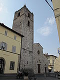
- Collegiata di Santa Maria Assunta , collegiate church in the center of the village. Was built in 1278, the campanile dates from 1365. In 1515 Pope Leo X proclaimed it a collegiate church . Contains the work Annunciazione by Stefano Tofanelli , a Comunione degli Apostoli by Piero Dandini , an Incoronazione della Vergine by Benedetto Brandimarte and a Cristo in Croce from the 14th century.
- Chiesa di San Michele , Romanesque church in the center of the village, which was completely restored after the Second World War.
- Chiesa dell'Immacolata Concezione e di San Lazzaro , church built by the Franciscans in 1610 with a convent . Contains the work Santi Giorgio, Bernardino, Francesco by Tiberio Franchi from 1651.
- Pieve di Santo Stefano , Pieve , which is about 1 km southwest of the town center. Was built around the 12th century on an older church that was probably built in the 10th century.
- Museo d'Arte Sacra , Art Museum in the center. Contains a Santissima Trinità (cast iron work) by Giovanni Vambré , a wooden painting by Vincenzo di Antonio Frediani ( Madonna in trono con il Bambino fra i santi San Giovanni Battista, Sant'Andrea, San Pietro e San Sebastiano , comes from the Chiesa di Santa Maria Albiano ) and an Arazzo dell'Ultima Cena from 1516
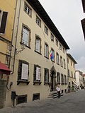
- Civico Museo Archeologico , archaeological museum in the Palazzo Tori Massoni in the historic center.
- Chiesa della Santissima Concezione , also called Chiesa dei Francescani , church just outside the city walls, which is under the Franciscans and dates from the 17th century.
Collegiata di Santa Maria Assunta

Fountain in front of the Collegiata
Museo d'Arte sacra
Civico Museo Archeologico

Lido di Camaiore promenade

Side street in Lido di Camaiore
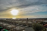
On the beach of Lido di Camaiore

Lido di Camaiore in the evening


.jpeg)
Sports
Lido di Camaiore was the destination of a stage of the Giro d'Italia in 1997 , 2002 and 2007 .
traffic
- Strada Statale 1 Via Aurelia and the historic Via Aurelia run through the local area . The A 12 motorway also runs through the municipality, but the next junction (Viareggio-Camaiore) is already in the Viareggio municipality after the junction to the A11 / A12 autostrada .
- The place is connected to the rail traffic with the stop Camaiore Lido-Capezzano on the railway line Pisa-Genoa .
Partnerships
Camaiore has partnerships with
-
 Carpentras in Provence , France
-
 Castel di Casio in the Emilia-Romagna region , Italy
 -
L'Hôpital , France
-
 Rovinj in Istria , Croatia
-
 Überherrn in Saarland , Germany
sons and daughters of the town
- Ludovico Marracci (1612–1700), priest, theologian and translator of the Koran into Latin
- Francesco Gasparini (1661–1727), composer and church musician of the Baroque
- Ermenegildo Pellegrinetti (1876–1943), Vatican diplomat and cardinal
- Zita von Bourbon-Parma (1892–1989), last Empress of Austria and Queen of Hungary
- Nicola Larini (* 1964), Formula 1 and touring car racing driver
- Francesco Chicchi (* 1980), racing cyclist
literature
- Emanuele Repetti: CAMAJORE di VERSILIA nella Marina Lucchese. In Dizionario Geografico Fisico Storico della Toscana (1833–1846), online edition of the University of Siena (pdf, ital.)
- Touring Club Italiano : Toscana , Milan 2003, ISBN 88-365-2767-1 , p. 148 ff.
Web links
Individual evidence
- ↑ Statistiche demografiche ISTAT. Monthly population statistics of the Istituto Nazionale di Statistica , as of December 31 of 2019.
- ↑ Website of the Agenzia nazionale per le nuove tecnologie, l'energia e lo sviluppo economico sostenibile (ENEA), accessed on November 12, 2013 (Italian) (PDF; 330 kB)
- ↑ Official website of the Sistema Informativo Ambientale della Regione Toscana (SIRA) on the rivers in Camaiore , accessed on November 15, 2013 (Italian)
- ↑ Comune di Camaiore with the population figures from 2011, accessed on July 4, 2019 (Italian)
- ↑ a b Emanuele Repetti: CAMAJORE di VERSILIA nella Marina Lucchese.
- ↑ a b c d e Touring Club Italiano: Toscana.
- ↑ a b Regione Toscana: I luoghi della Fede (Versilia), online version , accessed on November 13, 2013 (Italian)
- ↑ Official website of the Museo d'Arte sacra Camaiore , accessed on July 4, 2019 (Italian)
- ↑ Museo d'Arte Sacra di Camaiore , accessed on July 4, 2019 (Italian)
- ↑ Official website of the Museo Archeologico , accessed July 4, 2019 (Italian)
- ↑ Official website of the municipality of Camaiore to the community partnerships ( Memento of 11 May 2015, Internet Archive ), called (Italian) on November 15, 2013

Altopascio | Bagni di Lucca | Barga | Borgo a Mozzano | Camaiore | Camporgiano | Capannori | Careggine | Castelnuovo di Garfagnana | Castiglione di Garfagnana | Coreglia Antelminelli | Fabbriche di Vergemoli | Forte dei Marmi | Fosciandora | Gallicano | Lucca | Massarosa | Minucciano | Molazzana | Montecarlo | Pescaglia | Piazza al Serchio | Pietrasanta | Pieve Fosciana | Porcari | San Romano in Garfagnana | Seravezza | Sillano Giuncugnano | Stazzema | Vagli Sotto | Viareggio | Villa Basilica | Villa Collemandina
← Previous location: Pietrasanta 8.2 km | Camaiore | Next town: Lucca 24.2 km →
![]() Canterbury |
Dover |
Calais |
Wissant |
Guînes |
Licques |
Wisques |
Thérouanne |
Auchy-au-Bois |
Bruay-la-Buissière |
Arras |
Bapaume |
Peronne |
Doingt |
Seraucourt-le-Grand |
Tergnier |
Laon |
Bouconville-Vauclair |
Corbeny |
Hermonville |
Reims |
Trépail |
Châlons-en-Champagne |
Cool |
Brienne-le-Château |
Bar-sur-Aube |
Châteauvillain |
Blessonville |
Langres |
Humes-Jorquenay |
Coublanc |
Grenant |
Dampierre-sur-Salon |
Savoyeux |
Seveux |
Gy |
Cussey-sur-l'Ognon |
Besançon |
Étalans |
Chasnans |
Nods |
Ouhans |
Pontarlier |
Yverdon-les-Bains |
Orbe |
Lausanne |
Cully |
Vevey |
Montreux |
Villeneuve |
Aigle |
Saint-Maurice |
Martigny |
Orsières |
Bourg-Saint-Pierre |
Great St. Bernhard |
Saint-Rhémy-en-Bosses |
Saint-Oyen |
Étroubles |
Gignod |
Aosta |
Saint-Christophe |
Quart |
Nut |
Verrayes |
Chambave |
Saint-Denis |
Châtillon |
Saint-Vincent |
Montjovet |
Issogne |
Verrès |
Arnad |
Hône |
Bard |
Donnas |
Pont-Saint-Martin |
Carema |
Settimo Vittone |
Borgofranco d'Ivrea |
Montalto Dora |
Ivrea |
Cascinette d'Ivrea |
Burolo |
Bollengo |
Palazzo Canavese |
Piverone |
Azeglio |
Viverone |
Roppolo |
Cavaglià |
Santhià |
San Germano Vercellese |
Olcenengo |
Salasco |
Sali Vercellese |
Vercelli |
Palestro |
Robbio |
Nicorvo |
Castelnovetto |
Albonese |
Mortara |
Cergnago |
Tromello |
Garlasco |
Gropello Cairoli |
Villanova d'Ardenghi |
Zerbolò |
Carbonara al Ticino |
Pavia |
Valle Salimbene |
Linarolo |
Belgioioso |
Torre de 'Negri |
Costa de 'Nobili |
Santa Cristina e Bissone |
Miradolo Terme |
Chignolo Po |
San Colombano al Lambro |
Orio Litta |
Senna Lodigiana |
Calendasco |
Rottofreno |
Piacenza |
Podenzano |
San Giorgio Piacentino |
Pontenure |
Carpaneto Piacentino |
Cadeo |
Fiorenzuola d'Arda |
Chiaravalle della Colomba |
Alseno |
Busseto |
Fidenza |
Costamezzana |
Noceto |
Medesano |
Fornovo di Taro |
Terenzo |
Berceto |
Pontremoli |
Filattiera |
Villafranca in Lunigiana |
Bagnone |
Licciana Nardi |
Aulla |
Santo Stefano di Magra |
Sarzana |
Castelnuovo Magra |
Ortonovo |
Luni |
Fosdinovo |
Carrara |
Massa |
Montignoso |
Seravezza |
Pietrasanta |
Camaiore |
Lucca |
Capannori |
Porcari |
Montecarlo |
Altopascio |
Castelfranco di Sotto |
Santa Croce sull'Arno |
Ponte a Cappiano |
Fucecchio |
San Miniato |
Castelfiorentino |
Coiano |
Montaione |
Gambassi Terme |
San Gimignano |
Colle di Val d'Elsa |
Badia a Isola |
Monteriggioni |
Siena |
Monteroni d'Arbia |
Ponte d'Arbia |
Buonconvento |
Montalcino |
Torrenieri |
San Quirico d'Orcia |
Bagno Vignoni |
Castiglione d'Orcia |
Radicofani |
San Casciano dei Bagni |
Abbadia San Salvatore |
Piancastagnaio |
Ponte a Rigo |
Proceno |
Acquapendente |
Grotte di Castro |
San Lorenzo Nuovo |
Bolsena |
Montefiascone |
Viterbo |
Ronciglione |
Vetralla |
Capranica |
Sutri |
Monterosi |
Nepi |
Mazzano Romano |
Campagnano di Roma |
Formello |
La Storta |
Rome
Canterbury |
Dover |
Calais |
Wissant |
Guînes |
Licques |
Wisques |
Thérouanne |
Auchy-au-Bois |
Bruay-la-Buissière |
Arras |
Bapaume |
Peronne |
Doingt |
Seraucourt-le-Grand |
Tergnier |
Laon |
Bouconville-Vauclair |
Corbeny |
Hermonville |
Reims |
Trépail |
Châlons-en-Champagne |
Cool |
Brienne-le-Château |
Bar-sur-Aube |
Châteauvillain |
Blessonville |
Langres |
Humes-Jorquenay |
Coublanc |
Grenant |
Dampierre-sur-Salon |
Savoyeux |
Seveux |
Gy |
Cussey-sur-l'Ognon |
Besançon |
Étalans |
Chasnans |
Nods |
Ouhans |
Pontarlier |
Yverdon-les-Bains |
Orbe |
Lausanne |
Cully |
Vevey |
Montreux |
Villeneuve |
Aigle |
Saint-Maurice |
Martigny |
Orsières |
Bourg-Saint-Pierre |
Great St. Bernhard |
Saint-Rhémy-en-Bosses |
Saint-Oyen |
Étroubles |
Gignod |
Aosta |
Saint-Christophe |
Quart |
Nut |
Verrayes |
Chambave |
Saint-Denis |
Châtillon |
Saint-Vincent |
Montjovet |
Issogne |
Verrès |
Arnad |
Hône |
Bard |
Donnas |
Pont-Saint-Martin |
Carema |
Settimo Vittone |
Borgofranco d'Ivrea |
Montalto Dora |
Ivrea |
Cascinette d'Ivrea |
Burolo |
Bollengo |
Palazzo Canavese |
Piverone |
Azeglio |
Viverone |
Roppolo |
Cavaglià |
Santhià |
San Germano Vercellese |
Olcenengo |
Salasco |
Sali Vercellese |
Vercelli |
Palestro |
Robbio |
Nicorvo |
Castelnovetto |
Albonese |
Mortara |
Cergnago |
Tromello |
Garlasco |
Gropello Cairoli |
Villanova d'Ardenghi |
Zerbolò |
Carbonara al Ticino |
Pavia |
Valle Salimbene |
Linarolo |
Belgioioso |
Torre de 'Negri |
Costa de 'Nobili |
Santa Cristina e Bissone |
Miradolo Terme |
Chignolo Po |
San Colombano al Lambro |
Orio Litta |
Senna Lodigiana |
Calendasco |
Rottofreno |
Piacenza |
Podenzano |
San Giorgio Piacentino |
Pontenure |
Carpaneto Piacentino |
Cadeo |
Fiorenzuola d'Arda |
Chiaravalle della Colomba |
Alseno |
Busseto |
Fidenza |
Costamezzana |
Noceto |
Medesano |
Fornovo di Taro |
Terenzo |
Berceto |
Pontremoli |
Filattiera |
Villafranca in Lunigiana |
Bagnone |
Licciana Nardi |
Aulla |
Santo Stefano di Magra |
Sarzana |
Castelnuovo Magra |
Ortonovo |
Luni |
Fosdinovo |
Carrara |
Massa |
Montignoso |
Seravezza |
Pietrasanta |
Camaiore |
Lucca |
Capannori |
Porcari |
Montecarlo |
Altopascio |
Castelfranco di Sotto |
Santa Croce sull'Arno |
Ponte a Cappiano |
Fucecchio |
San Miniato |
Castelfiorentino |
Coiano |
Montaione |
Gambassi Terme |
San Gimignano |
Colle di Val d'Elsa |
Badia a Isola |
Monteriggioni |
Siena |
Monteroni d'Arbia |
Ponte d'Arbia |
Buonconvento |
Montalcino |
Torrenieri |
San Quirico d'Orcia |
Bagno Vignoni |
Castiglione d'Orcia |
Radicofani |
San Casciano dei Bagni |
Abbadia San Salvatore |
Piancastagnaio |
Ponte a Rigo |
Proceno |
Acquapendente |
Grotte di Castro |
San Lorenzo Nuovo |
Bolsena |
Montefiascone |
Viterbo |
Ronciglione |
Vetralla |
Capranica |
Sutri |
Monterosi |
Nepi |
Mazzano Romano |
Campagnano di Roma |
Formello |
La Storta |
Rome![]()
![]()
![]()