Piancastagnaio
| Piancastagnaio | ||
|---|---|---|

|
|
|
| Country | Italy | |
| region | Tuscany | |
| province | Siena (SI) | |
| Coordinates | 42 ° 51 ' N , 11 ° 41' E | |
| height | 772 m slm | |
| surface | 69 km² | |
| Residents | 4,064 (Dec 31, 2019) | |
| Population density | 59 inhabitants / km² | |
| Post Code | 53025 | |
| prefix | 0577 | |
| ISTAT number | 052020 | |
| Popular name | Pianesi | |
| Patron saint | San Filippo Neri (May 26) | |
| Website | Piancastagnaio municipality | |
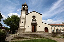
 Panorama of Piancastagnaio |
||
Piancastagnaio is a place with 4064 inhabitants (as of December 31, 2019) in the province of Siena , Tuscany region in Italy .
geography
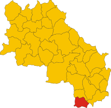
The place extends over 69 km² . It is located about 60 km southeast of the provincial capital Siena and about 110 km southeast of the regional capital Florence . To the west the place borders on the province of Grosseto , to the south on Viterbo ( Lazio region ). The place is in the climatic classification of Italian municipalities in zone E, 2 629 GG and on the rivers Paglia (1 km in the municipality) and Siele (5 km in the municipality). The place is in the Diocese of Pitigliano-Sovana-Orbetello and thus belongs to the Archdiocese of Siena-Colle di Val d'Elsa-Montalcino . The historic center is divided into thirds ( terzi , also / or terzieri ): Castello , Borgo and Voltaia .
The only district (frazione) is Saragiolo (901 m, approx. 370 inhabitants). Other locations (località) or hamlets are Quaranta (956 m, approx. 50 inhabitants) and Tre Case (842 m, approx. 120 inhabitants).
The neighboring municipalities are Abbadia San Salvatore , Castell'Azzara ( GR ), Proceno ( VT ), San Casciano dei Bagni and Santa Fiora (GR).
history
From the 11th century, the place was under the rule of the feudal lord family of the Aldobrandeschi . At the end of the same century, civil rule was divided between the feudal lords and the monastery of Abbadia San Salvatore. In the 13th century the Visconti di Campiglia ruled , then Orvieto . In 1415 Siena conquered the place, after its defeat (1555) Florence gained dominion. They gave the place in 1600 to the Bourbon del Monte Santa Maria in feudal ownership. Through the reforms of Leopold II , the place became an independent municipality.
Palio and Contrade
The Palio di Piancastagnaio takes place every year on August 18th and is a Palio that is played on horses. It has probably been held since the 16th century, but the winners have only been documented since 1954. At the Palio, the four contrades (German districts / districts) of the historic old town compete against each other. These contaden are:
- Borgo (yellow-blue coat of arms with black horse)
- Coro (red and black coat of arms with golden eagle)
- Castello (red-green coat of arms with golden castle)
- Voltaia (black and white coat of arms with oak in the city gate)
Attractions
- Castello degli Aldobrandeschi , also Rocca aldobrandesca , medieval castle in the town center (Castello).
- Pieve di Santa Maria Assunta , already mentioned in 1188 Pieve . The Santissimo Sacramento chapel contains frescoes ( Santo Stefano ), a baptismal font from the 15th and 16th centuries. Century and a portal from 1617. The chapel Santissima Annunziata dates from the 16th century and possesses the wooden statue Cristo morto (1864) by Pasquale Leoncini .
- Chiesa della Madonna delle Grazie , church in the town center (Borgo), contains frescoes from 1468 by Nanni di Pietro the fresco cycle Madonna assunta con i Santi Michele arcangelo, Pietro e Bartolomeo , Eterno in gloria con i quattro evangelisti , Decollazione del Battista , Martirio di San Sebastiano and others.
- Chiesa di San Filippo Neri , church in the town center (Castello). Contains the canvas painting Apparizione della Madonna col Bambino a San Filippo Neri (18th century).
- Sinagoga , former synagogue in the town center (Borgo).
- Palazzo Comunale (13th century, Piazza dell'Orologio, Borgo)
- Palazzo del Podestà (15th century, Piazza dell'Orologio, Borgo)
- Torre dell'Orologio (Piazza dell'Orologio, Borgo)
- Palazzo del Marchese Bourbon del Monte (built from 1603, Borgo)
- City walls of Piancastagnaio, with the city gates:
- Porta del Castello , northern gate near the Castello.
- Porta della Fontanella , southern gate near the Fontanella fountain and the Madonna delle Grazie church.
- Porta di Voltaia , also called Porta Castellana or del Cancello . West gate leading to the Fonte di Voltaia fountain.
- Porticciola , southwest gate near the Palazzo del Monte.
- Porta Montanina , meanwhile located in the center.
- Chiesa di San Francesco , consecrated church outside the city walls in 1278 with the adjacent convent of San Bartolomeo, which was active until 1812. Contains the fresco Strage degli Innocenti (14th century).
- Santuario della Madonna di San Pietro , sanctuary outside the city walls. Documented as a church in 1188. Contains several works by Francesco Nasini ( Miracolo di Sant'Andrea Corsini , Ecce Homo , Trionfo di San Michele ) and a Madonna col Bambino (1580) by Martino d'Urbano da Celia.
- Chiesa del Crocifisso , church in Tre Case. Originated near the tree where St. San Francesco d'Assisi sought rest, called Leccio delle Ripe. The church was built near the Franciscan convent and initially bore the title of Santissima Trinità.
- Chiesa della Madonna delle Grazie , church in Saragiolo.
Sports
The local soccer club US Pianese has played in the fourth-rate Serie D without interruption since 2010 .
Sons and daughters of the church
- Pietro Maria Pieri OSM (1676–1743), cardinal
- Cipriano Vagaggini (1909–1999), Benedictine
literature
- Ippolito Corridori, Arturo Santioli: L'Amiata. Edizioni Cantagalli, Siena 1987, pp. 73 ff.
- Emanuele Repetti: PIAN CASTAGNAJO denominato anche semplicemente PIANO, nella Valle della Paglia. In Dizionario Geografico Fisico Storico della Toscana (1833–1846), online edition of the University of Siena (pdf, Italian)
- Bruno Santi: I Luoghi della Fede. L'Amiata e la Val d'Orcia. Arnoldo Mondadori Editore , Milan 1999, ISBN 88-04-46780-0
- Touring Club Italiano : Toscana , Milan 2003, ISBN 88-365-2767-1 , p. 684 f.
Web links
- Official website of the municipality of Piancastagnaio
- Pro Loco of the municipality of Piancastagnaio
Individual evidence
- ↑ Statistiche demografiche ISTAT. Monthly population statistics of the Istituto Nazionale di Statistica , as of December 31 of 2019.
- ^ Comuni italiani zu Piancastagnaio, accessed on June 3, 2017 (Italian)
- ↑ tuttitalia on Piancastagnaio, accessed on June 3, 2017 (Italian)
- ↑ Website of the Agenzia nazionale per le nuove tecnologie, l'energia e lo sviluppo economico sostenibile (ENEA), accessed on June 3, 2017 (Italian) (PDF; 330 kB)
- ↑ Official website of the Sistema Informativo Ambientale della Regione Toscana (SIRA) on the rivers in Piancastagnaio , accessed on June 3, 2017 (Italian)
- ↑ a b Corridori / Santioli: L'Amiata.
- ↑ Official website of ISTAT ( Istituto Nazionale di Statistica ) on 2001 population figures in the province of Siena, accessed on June 3, 2017 (Italian)
- ^ Website of the Pro Loco of the municipality of Piancastagnaio on the Contraden , accessed on June 3, 2017 (Italian)
- ↑ a b c d e f Bruno Santi (Ed.): I luoghi della Fede. L'Amiata e la Val d'Orcia.
- ↑ a b c d Pro Loco Piancastagnaio
- ^ Anna Benvenuti: Santuari di Toscana. Edizioni Cooperativa Firenze 2000, Florence 2002, p. 259
- ↑ Official website of the association for the history of the association , accessed on June 3, 2017 (Italian)


