Lazio
| Lazio | |
|---|---|
|
|
|
| Basic data | |
| Capital | Rome |
| Provinces | 5 including metropolitan city of Rome |
| surface | 17,207.68 km² ( 9. ) |
| Residents | 5,865,544 (Dec. 31, 2019) |
| Population density | 341 inhabitants / km² |
| Website | www.regione.lazio.it |
| ISO 3166-2 | IT-62 |
| president | Nicola Zingaretti ( PD ) |
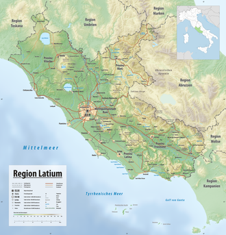
 Relief map of the Lazio region |
|
Latium ( Italian Lazio ) is a region in central Italy with 5,865,544 inhabitants (as of December 31, 2019). The most important city in Lazio is the Italian capital Rome . The area designation existed in ancient times, but the borders of Lazio have shifted in different places over the centuries.
location
In ancient times, Latium was understood to mean only the roughly rectangular area between the Tiber , Sabine Mountains , Sinuessa (today's Mondragone ) and the Tyrrhenian Sea .
Today's Lazio is about halfway up the "Italian boot" on its west coast on the Tyrrhenian Sea, which is part of the Mediterranean . The northernmost city is Acquapendente , the southernmost Gaeta . In the countryside, Lazio is surrounded (in the order from north to south) by the regions of Tuscany , Umbria , Marche , Abruzzo , Molise and Campania .
geography
Geologically, Lazio consists of three types of landscape.
- The limestone mountains of Abruzzo in eastern Lazio merge into the region of the same name. It occupies a large part of the Rieti Province. In it is the highest mountain in Lazio, the 2458 meter high Monte Gorzano , part of the Monti della Laga . In front of this are the Sabine Mountains , the Monti Lucretili , the Monti Ernici and the Monti della Meta . As a rule, the axis of the mountains runs in a north-west-south-east direction. This also applies to the mountain ranges of the Monti Lepini , the Monti Ausoni and the Monti Aurunci , located southeast of Rome . Geologically, the isolated mountains, Monte Soratte in the Tiber Valley and Monte Circeo on the coast, also belong to the limestone mountains.
- In contrast, the hilly country in the northwest of the Tuscia is characterized by tuff , a rock that is of volcanic origin and consists mainly of solidified volcanic ash. The tuff has often created deep canyons. The Monti Volsini on Lake Bolsena , the Monti Cimini around Lake Vico and the Monti Sabatini around Lake Bracciano protrude from it . They are weathered calderas of extinct volcanoes, just like the Alban Mountains east of Rome. The two crater lakes Albaner See and Nemisee are located in this mountain range .
- The plains make up a smaller part of Lazio. These are the Maremma laziale , which stretches from Tuscany to the Tolfa Mountains , the estuary of the Tiber southwest of Rome and the Pontine plain , whose swamps were only drained in the 1930s. The Pontine Islands are in front of it.
Most of the rivers - the Tiber with its tributary, the Aniene , the Marta and the Garigliano with its tributaries Liri and Sacco - flow into the Tyrrhenian Sea. Only the Tronto , which rises in the Monti della Laga, flows into the Adriatic Sea .
Park of Ninfa
history
In the 6th century BC The Latins settled in Lazio . In the Second Latin War from 340 to 338 BC BC subjugated Rome and the area became the core of the Roman Empire . After its fall , Lazio belonged to the Italian kingdom of Odoacer until 493 , and in 536 it was conquered by the Eastern Roman Empire . 755 the region was as a fief of the King of the Franks to the Pope , it became the core of the to be formed beginning Papal States . When the Franconian Empire was divided in 843 it fell to the Kingdom of Italy , but soon regained complete independence. In the course of Napoleon's Italian campaign , the Papal State was taken by French troops and Latium received a republican government based on the model of the Directory of the French Revolution . But as early as 1799, the First Napoleonic War put an end to the republic. In 1801 Pope Pius VII brought Napoleon to give in, who now restored the papal state. However, due to the Pope's refusal to participate in an alliance against Great Britain, the Papal States occupied the Papal States again in 1807/08, and in 1809 it was declared annexed by Napoleon. At the Congress of Vienna in 1815, however, it was decided to restore it. In 1860 Umbria and the Marches joined the newly formed Kingdom of Italy due to political, economic and military uncertainty . In 1870 the papal state, which was now limited to Lazio, was incorporated into the Italian nation- state. The Lazio region has been an administrative unit since 1947.
Administrative division
Lazio consists of the following four provinces and one metropolitan city :
| Province or metropolitan city | Capital | ISO | Communities | Population (December 31, 2019) |
Area (km²) | Population density (inh / km²) |
|---|---|---|---|---|---|---|
| Frosinone | Frosinone | IT-FR | 91 | 485.241 | 3,243.95 | 150 |
| Latina | Latina | IT LT | 33 | 576,655 | 2,256.16 | 256 |
| Rieti | Rieti | IT-RI | 73 | 154,232 | 2,749.16 | 56 |
| Rome | Rome | IT RM | 121 | 4,333,274 | 5,351.81 | 810 |
| Viterbo | Viterbo | IT-VT | 60 | 316.142 | 3,612.24 | 88 |
| Lazio | Rome | IT-62 | 378 | 5,865,544 | 17,207.68 | 341 |
There are the following cities and larger municipalities in the region.
| local community | province | Residents |
|---|---|---|
| Rome | Rome | 2,705,317 |
| Latina | Latina | 116.234 |
| Guidonia Montecelio | Rome | 89,256 |
| Aprilia | Latina | 67,260 |
| Fiumicino | Rome | 65,088 |
| Viterbo | Viterbo | 61,437 |
| Pomezia | Rome | 57,254 |
| Tivoli | Rome | 53,095 |
| Velletri | Rome | 51,925 |
| Civitavecchia | Rome | 51,923 |
| Anzio | Rome | 50.205 |
| Frosinone | Frosinone | 48,256 |
| Rieti | Rieti | 47,634 |
| Nettuno | Rome | 43,780 |
| Terracina | Latina | 43,298 |
| Ardea | Rome | 39,626 |
| Albano Laziale | Rome | 39,137 |
| Marino | Rome | 38,478 |
| Ladispoli | Rome | 38,435 |
| Ciampino | Rome | 37,938 |
| Monterotondo | Rome | 37,916 |
| Formia | Latina | 37,242 |
| Fondi | Latina | 36,479 |
| Cerveteri | Rome | 34,727 |
| Cisterna di Latina | Latina | 34,100 |
| Cassino | Frosinone | 32,929 |
| Alatri | Frosinone | 29,059 |
| Fonte Nuova | Rome | 26,802 |
| Sora | Frosinone | 26,441 |
| Sezze | Latina | 23,988 |
| Genzano di Roma | Rome | 23,356 |
| Ceccano | Frosinone | 22,740 |
| Gaeta | Latina | 21,711 |
| Frascati | Rome | 20,768 |
| Colleferro | Rome | 21,885 |
| Anagni | Frosinone | 21,332 |
| Ferentino | Frosinone | 20,968 |
| Grottaferrata | Rome | 20,709 |
| Veroli | Frosinone | 20,596 |
| Mentana | Rome | 20,066 |
Status: March 31, 2008 Source: ISTAT
economy
Compared with the GDP of the European Union (expressed in purchasing power standards) in 2015 reached the region an index of 110 (EU-28: 100). With a value of 0.890, Lazio ranks 4th among the 21 regions and autonomous provinces of Italy in the Human Development Index .
In 2017 the unemployment rate was 10.7%.
tourism
In addition to Rome, the Alban Mountains , the volcanic lakes of different sizes, of which the Lago di Bracciano and the Lago di Bolsena in the border triangle Tuscany / Umbria / Lazio are the largest, as well as southern Lazio, here in particular the monastery, are considered to be particularly attractive for tourists Monte Cassino , which was completely destroyed in World War II, but was rebuilt afterwards.
Web links
- Website of the Lazio region (Italian)
- Website of the Central Tourist Office of the Lazio Region (multilingual)
swell
- ↑ Statistiche demografiche ISTAT. Monthly population statistics of the Istituto Nazionale di Statistica , as of December 31 of 2019.
- ↑ Eurostat. Retrieved April 15, 2018 .
- ^ Sub-national HDI - Area Database - Global Data Lab. Retrieved August 12, 2018 .
- ↑ Unemployment rate, by NUTS 2 regions. Retrieved November 5, 2018 .
Coordinates: 41 ° 49 ' N , 12 ° 44' E


