Sardinia
| Sardinia | |
|---|---|
|
|
|
| Basic data | |
| Capital | Cagliari |
| Provinces | 5 including metropolitan city of Cagliari |
| surface | 24,089.89 km² ( 3. ) |
| Residents | 1,630,474 (Dec. 31, 2019) |
| Population density | 67.7 inhabitants / km² |
| Website | www.regione.sardegna.it |
| ISO 3166-2 | IT-88 |
| president | Christian Solinas ( PSd'Az ) |
 Relief map of the Sardinia region |
|
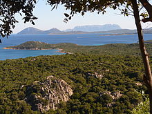
Sardinia ( Sardinian Sardigna , Italian Sardegna , Catalan Sardenya ) is - after Sicily - the second largest island in the Mediterranean . The Phoenicians named her on Nora Šrdn's stele . A foreign people , who were also called Šrdn (mostly transcribed to Scherden or Schardana), encountered in Egyptian texts from the 14th to 12th centuries BC. Chr .; however, it is disputed whether this came from Sardinia. The Euboians called the island "Ichnoussa" and the Greeks "Sandalyon" because their shape is reminiscent of a footprint.
The island forms with the small offshore islands the autonomous Italian region of the same name . The region of Sardinia has an area of 24,090 km² and a population of 1,630,474 (as of December 31, 2019). Their capital is Cagliari .
History and prehistory
population
Many Sardinians still speak some Sardinian , a language that belongs to the Romance family . In public life, however, only Italian dominates these days ; Due to the cultural and linguistic Italianization of the Sardinians since the late 18th century , the Sardinian language is very endangered. In addition, a Catalan dialect has been spoken in Alghero since the 14th century , and Corsican language islands can be found along the north coast .
Most of the Sardinian population belongs to the Roman Catholic Church .
Sardinia had the lowest birth rate in Italy in 2019 with 5.4 live births per 1000 inhabitants .
geography
location
Sardinia is an island in the Mediterranean that belongs politically to Italy . It is 190 km from the Monte Argentario peninsula and 202 km from mainland Italy; in between lies the Tyrrhenian Sea . To the north lies the to France is part of Corsica , only through the 12 km wide Strait of Bonifacio (Strait of Bonifacio) separately. In the West, 335 km away to is Spain belonging Balearic island of Menorca . In the south, Tunisia is 184 km away.
The north-south extension is approx. 270 km, the east-west extension approx. 145 km.
climate
The climate is essentially Mediterranean , with warm spring and autumn, hot summer and mild winter.
|
Climate table Cagliari
Source: Climate Sardinia
|
||||||||||||||||||||||||||||||||||||||||||||||||||||||||||||||||||||||||||||||||||||||||||||||||||||||||||||||||||||||||||||||||||||||||||||||||||||||||||||||||||||||||||||||||||||
Winch
- Tramontana - north wind: often occurs with very strong gusts and rain. Can occur in stable, fair weather conditions as well as in cloudy skies. In most cases there are short-term drops in temperature.
- Greco - northeast wind: cold, mostly gusty wind that often occurs in low pressure areas.
- Levante - east wind: light, warm wind that usually follows the mistral and heralds the strong Scirocco. It originates in the Sahara.
- Scirocco - southeast (south) wind: hot wind that blows from the southeast or often from the south. It can be very hot, especially in the summer months, and generate high levels of humidity. Occasionally it blows Sahara sand into Sardinia.
- Ostro - south wind: similar to the Scirocco, only in a weaker form and without Sahara sand.
- Libeccio - southwest wind: in winter light wind that can bring rain and thunderstorms. In summer, strong winds that develop strong gusts and usually result in rough seas.
- Ponente - west wind: weak wind that usually occurs in summer and ensures clear skies.
- Maestrale - northwest wind: stormy wind that occurs mostly in spring and autumn. Makes for cold but sunny weather.
Administrative division
For a long time, the autonomous region of Sardinia was politically divided into three provinces: Cagliari , Sassari and Nuoro . In 1974 the province of Oristano was re-established; between 2005 and 2016 there were four other provinces: Olbia-Tempio , Ogliastra , Carbonia-Iglesias and Medio Campidano . In the course of a new reclassification in February 2016, the province of Olbia-Tempio was part of the province of Sassari, the province of Ogliastra was reclassified into the province of Nuoro and the province of Sud Sardegna was formed from the provinces of Cagliari, Carbonia-Iglesias and Medio Campidano . The city of Cagliari and its surroundings became the metropolitan city of Cagliari .
| Province or metropolitan city | Capital | ISO | Communities | Population (December 31, 2019) |
Area (km²) | Population density (inh / km²) |
|---|---|---|---|---|---|---|
| Cagliari | Cagliari | IT-CA | 17th | 430.914 | 1,247.38 | 346 |
| Nuoro | Nuoro | IT-NU | 74 | 206.843 | 5,638.06 | 37 |
| Oristano | Oristano | IT-OR | 87 | 156.078 | 2,990.45 | 52 |
| Sassari | Sassari | IT-SS | 92 | 489,634 | 7,692.00 | 64 |
| South Sardegna | Carbonia | IT-SD | 107 | 347.005 | 6,530.00 | 53 |
| Sardinia | Cagliari | IT-88 | 377 | 1,630,474 | 24,089.89 | 68 |
Areas
The island is divided into areas (landscapes) that result from mountains or plains.
Cities

| city | Population December 31, 2019 |
|---|---|
| Cagliari | 153.231 |
| Sassari | 126,218 |
| Quartu Sant'Elena | 70,352 |
| Olbia | 61,323 |
| Alghero | 43,743 |
| Nuoro | 35,763 |
| Oristano | 31,469 |
| Selargius | 29.202 |
| Carbonia | 27,611 |
| Assemini | 26,848 |
| Iglesias | 26,300 |
Coastal
Including the small offshore islands, Sardinia has a coastline of 1,848.6 kilometers. Some parts of the coast have well-known names: Costa Smeralda - Costa Rei - Costa Verde - Costa Paradiso - Costa del Sud .
Rivers
The longest rivers in Sardinia are the Tirso, which flows out at Oristano on the west coast, with a length of 150 km, the Coghinas with 123 km, the Flumendosa, which flows into the sea on the south east coast, with 122 km and the six to eight kilometers long navigable Temo, which flows out at Bosa .
mountains
The highest mountains are the Punta La Marmora at 1834 m slm and the Bruncu Spina at 1829 m in the centrally located Gennargentu Mountains . In the north the 1359 m high Monte Limbara dominates . Geological peculiarities are the gold , silver and iron , especially in the southern part of the island.
Islands
There are numerous islands off the main island of Sardinia:
| Asinara | La Maddalena | |
| Mal di Ventre |

|
Ogliastra |
| Sulcis archipelago with the islands of San Pietro , Sant'Antioco , Isola il Toro and Isola la Vacca | Cavoli , Serpentara |
fauna
Sardinia is a nature reserve in which thousands of rare animal and plant species are protected.
Mammals
Selection of previously known mammal species:
- Tyrrhenian red deer (Cervus elaphus corsicanus)
- Fallow deer (Dama dama)
- Mouflon (Ovis musimon)
- Sardinian long-eared (Plecotus sardus)
- Wild boar (Sus scrofa meridionalis)
- Giara horse
Birds
Selection of known bird species:
- Scops Owl (Otus scops)
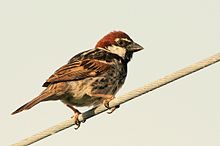
- Willow Sparrow (Passer hispaniolensis)
- Musk duck (Cairina moschata)
- Stilt (himantopus himantopus)
- Greater Flamingo (Phoenicopterus roseus)
Amphibians
Selection of previously known amphibian species:
- Sardinian newt (Euproctus platycephalus)
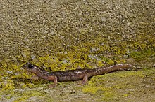
- Sarrabus cave salamander (Speleomantes sarrabusensis)
- West Sardinian Cave Salamander (Hydromantes genei)
- Northeast Sardinian Cave Salamander (Hydromantes flavus)
- Southeast Sardinian Cave Salamander (Hydromantes imperialis)
- Middle Eastern Sardinian Cave Salamander (Hydromantes supramontis)
- Sardinian disc beater (Discoglossus sardus)
- Green toad (Bufo viridis)
- Tyrrhenian tree frog (Hyla sarda)
Reptiles
Selection of previously known reptile species:
- Greek tortoise (Testudo hermanni)
- Moorish tortoise (Testudo graeca)
- Wide-brimmed tortoise (Testudo marginata)
- European pond turtle (Emys orbicularis)
- European half finger (Hemidactylus turcicus)
- European leaf finger (Phyllodactylus europaeus)
- Wall gecko (Tarentola mauritanica)
- Dwarf keel lizard (Algyroides fizingeri)
- Tyrrhenian mountain lizard (Lacerta bedriagae)
- Ruined lizard (Podarcis sicula)
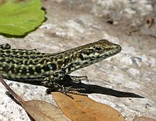
- Tyrrhenian wall lizard (Podarcis tiliguerta)
- Spotted roller skink (Calcides ocellatus)
- Skink (Calcides calcides)
- Horseshoe snake (Coluber hippocrepis)
- Yellow-green angry snake (Hierophis viridiflavus)
- Aesculapian snake (Elaphe longissima)
- Grass snake (Natrix natrix)
- Viper snake (Natrix maura)
Transport and traffic
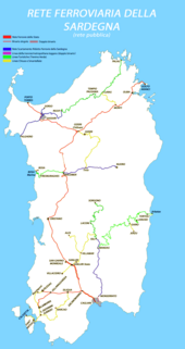
In addition to the railways of the Ferrovie dello Stato Italiane, there are several narrow-gauge regional lines of the Ferrovie della Sardegna as well as their tourism project under their popular name Trenino Verde u. a. between Bosa Marina - Macomer and Arbatax - Mandas. The electrification of the Ferrovie dello Stato lines was started - unlike the electrified lines on the mainland and Sicily with single-phase alternating current 25 kV / 50 Hz - but stopped after a short construction period. The public intercity transport consists primarily of a close-knit network of intercity bus connections , which are served by different companies. In 2016, the degree of motorization (passenger cars per 1000 inhabitants) was 619.
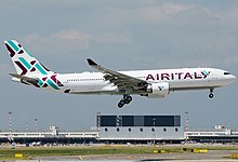
In addition to the commercial airports of Cagliari , Olbia and Alghero, there are also civil airports at Oristano (Fenosu) and Arbatax (Tortolì) in Sardinia . There has been no flight operation from the latter two since 2011.
A few kilometers northwest of Cagliari Airport is the Decimomannu military airfield , which is also used by NATO forces, including the German Air Force until 2016 (Tactical Training Command of the Air Force in Italy - TaktAusbKdoLwIT (dissolved)). In Salto di Quirra there is a launch site for military rockets and rockets for exploring the high atmosphere.
Sardinian literature
coat of arms
Description: In silver a continuous red will cross from to the left facing Moors heads bewinkelt with silver hair band. The flag is said to go back to Peter I of Aragon to commemorate his victory in the Battle of Alcoraz during the Reconquista .
economy
Compared with the GDP of the EU Sardinia in 2017 reached, expressed in purchasing power standards, an index of 70 (EU-28 = 100). With a value of 0.863, Sardinia ranks 15th among the 20 regions of Italy in the Human Development Index . In 2017 the unemployment rate was 17%.
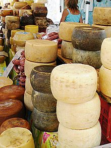
The Sardinian economy lives mainly from tourism and the oil industry ; other important areas: trade, services, information technology and gastronomy. Wine ( Cannonau ) and sheep's cheese ( Pecorino sardo ) are also important . In the north of the island, traditional cork production plays a prominent role.
tourism
In 2009 Sardinia recorded 2,456,746 arrivals and almost 12.3 million overnight stays. 199,042 beds were available in the accommodation establishments.
Historical goals

Geographical sights
- List of natural parks in Italy / Sardinia
- The red rocks of Arbatax
- Capo d'Orso
- Capo Testa
- Gennargentu
- Grotta del Bue Marino
- Grotta di Nettuno
- Grotta su Marmuri
- Grotta di Ispinigoli
- The mountain and coastal roads between the equally worth seeing places Alghero and Bosa
- Parco del Sulcis
- La Maddalena (island)
- Porto Cervo
- Roccia dell'elefante
- Supramonte
Culinary specialties
Food
- Pecorino , a sheep cheese
- Pane Carasau , thin, dried shepherd's bread , also called carta di musica (music paper); is made from wheat flour, yeast and salt; the thin flat cakes are baked twice quickly and very hot so that they can be kept for a long time
- Pane Guttiau , a version of Pane Carasau with olive oil
- Porcheddu , grilled suckling pig
- Culurgionis , a Sardinian pasta specialty, comparable to ravioli
- Seadas / Sebadas , large cheese pockets baked in olive oil with honey (dessert)
- Fregula , a common type of durum wheat semolina in a small spherical shape
- Malloreddus , small Sardinian gnocchi (type of pasta)
- Bottarga , dried roe, especially mullet, are used in pasta dishes (mainly spaghetti )
- Casu Marzu , overripe sheep's cheese with fly maggots
beverages
- Cannonau (also called Grenache ), a strong red wine
- Monica Nera , also under the synonym Monica di Sardegna, an autochthonous red wine grape from Sardinia
- Vermentino di Gallura , the only white wine from Sardinia with DOCG designation
- Vernaccia di Oristano , a white wine
- Ichnusa , lager brewed from corn meal
- Mirto , white or red liqueur made from the fruits of the myrtle that is common on the island
- Limoncello , a sweet lemon liqueur
Trivia
Sardinia is the namesake of two types of mineral that were first discovered on the island . The sardignaite, named in 2008 after the Sardinian name of the island, and the ichnusaite , named in 2013 after the ancient Greek name, were discovered in the mine of Punta de su Seinargiu (also Su Seinargiu) west of the municipality of Sarroch .
Judiciary
See also
literature
- Giulio Angioni : Sardinia: an island for every season , Umschau, Munich 1994, ISBN 3-524-67060-1 .
- Patricia Bourcillier: SardegnaMadre (version française). Flying Publisher, 2003, 268 pp., PDF ( ISBN 3-924774-38-2 ) .
- Jean Germain : Bibliography sélective de linguistique française et romane. Boeck Université, éd Duculot, 1997 ISBN 2-8011-1160-0 .
- Martin Kremp: The Arabs in the western Mediterranean: Sardinia, Corsica, Malta. Mediterranea, Frankfurt am Main 2004.
Web links
- Official regional website (Italian)
- Sardegna Turismo, the Official Tourism Portal of Sardinia (multilingual)
- Link catalog on Sardinia at curlie.org (formerly DMOZ )
Individual evidence
- ↑ Statistiche demografiche ISTAT. Monthly population statistics of the Istituto Nazionale di Statistica , as of December 31 of 2019.
- ^ Istituto Nazionale di Statistica (ISTAT): Nuovo minimo storico di nascite dall'unità d'Italia. Superato il record negativo del 2018. Valori minimi in Liguria e Sardegna , July 13, 2020, accessed on July 14, 2020.
- ↑ Legge regional approvata il 27 marzo 2016 . consregsardegna.it. Retrieved April 24, 2016.
- ↑ ec.europa.eu
- ↑ Eurostat. Retrieved April 15, 2018 .
- ^ Sub-national HDI - Area Database - Global Data Lab. Retrieved August 12, 2018 .
- ↑ Unemployment rate, by NUTS 2 regions. Retrieved November 5, 2018 .
- ↑ Sardinia - Interesting facts and figures ( Memento of the original from January 16, 2014 in the Internet Archive ) Info: The archive link was inserted automatically and has not yet been checked. Please check the original and archive link according to the instructions and then remove this notice. . Retrieved January 16, 2014.
- ↑ P. Orlandi, M. Pasero, S. Bigi: Sardignaite: a new mineral, the second known bismuth molybdate: description and crystal structure. In: Mineralogy & Petrology , Volume 100 (2010), pp. 17-22 DOI: 10.1007 / s00710-010-0111-0 , see also Mineralienatlas: Sardignait
Coordinates: 40 ° 2 ' N , 9 ° 4' E


