Oristano
| Oristano | ||
|---|---|---|

|
|
|
| Country | Italy | |
| region | Sardinia | |
| province | Oristano (OR) | |
| Local name | Aristanis | |
| Coordinates | 39 ° 54 ' N , 8 ° 35' E | |
| height | 9 m slm | |
| surface | 84.63 km² | |
| Residents | 31,469 (Dec. 31, 2019) | |
| Population density | 372 inhabitants / km² | |
| Factions | Donigala, Massama, Nuraxinieddu, Silì, Torre Grande | |
| Post Code | 09170 | |
| prefix | 0783 | |
| ISTAT number | 095038 | |
| Popular name | Oristanesi | |
| Patron saint | Sant'Archelao | |
| Website | Oristano | |
 View of Oristano |
||
Oristano ( Sardinian Maristanis or Aristanis - between the lagoons) is an Italian city with 31,469 inhabitants (as of December 31, 2019) in western Sardinia .
geography
Oristano is the capital of the province of the same name Oristano (provincial abbreviation: OR) and is located in the northwest of the fertile Campidano plain . Here the Tirso , the longest river in Sardinia, flows into the sea; because of its floods it is called the Sardinian Nile.
history
In the 9th century BC Tharros , located on the coast of the Sinis Peninsula , was already a Phoenician trading center in the western Mediterranean. The Romans came and went. The geographer Giorgio Ciprio mentioned since 534 n. Chr. To Byzantium part of town, in the year 636. When the raids of the Moors accumulated, Oristano was built with the stones of the Punic coastal settlement Tharros to 1070 laid the judge Onroccus di Arborea the Capital of the judiciary from Tharros to nearby Aristanis.
The history of the city is mainly linked to the Arborea judiciary and the great times of the judges Mariano IV and Eleonora di Arborea . As the capital of the judiciary, the city controlled half of Sardinia at the time. In 1409 the judge Guglielmo II lost the battle of Sanluri against the Spanish crown and the judiciary lost influence. In 1478 the island came under Spanish rule.
The Sardinian Action Party was founded here in 1921 .
Culture and sights
Buildings
- The cathedral, cathedral of the Archdiocese of Oristano , was built from 1228 under the judge Marianus and later rebuilt and expanded several times.
- Some defense towers have been preserved, which used to be part of the city fortifications, which the judge Marianus II had built in 1291. These include the Torre di Mariano II (also known as Torre San Cristoforo or Porta Manna ) and the Torre di Portixedda .
- The Palazzo di Eleonora dates from the early Renaissance period and now houses the town hall.
- The Oratorio delle Anime is located in the suburb of Massama.
- The Romanesque cathedral of Santa Giusta is three kilometers south of Oristano.
Basilica of Santa Giusta

Museums
- In the Antiquarium Arborense in Via Parpaglia, finds from the region's early history are on display.
- The Pinacoteca in Via San Antonio houses works by important Sardinian artists.
Regular festivals
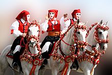
In Oristano on Sunday there before Rose Monday every year the Sartiglia instead, must pierce a suspended star at the masked rider.
Economy and Infrastructure
Oristano is the main agricultural center of Sardinia. The city has an airport and a train station on the Cagliari – Golfo Aranci Marittima railway line .
Town twinning
Oristano has been in partnership with the Spanish city of Ciutadella on Menorca since 1991.
literature
- Peter Höh: Sardinia. 4th edition 2006, Reise Know-How Verlag, Bielefeld, ISBN 3-8317-1464-9
Web links
- Official Homepage (Italian)
- Information about the Sartiglia (German)
- Oristano and Sinis Peninsula (German)
Individual evidence
- ↑ Statistiche demografiche ISTAT. Monthly population statistics of the Istituto Nazionale di Statistica , as of December 31 of 2019.


