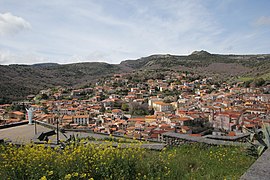
Santu Lussurgiu
| Santu Lussurgiu | ||
|---|---|---|

|
|
|
| Country | Italy | |
| region | Sardinia | |
| province | Oristano (OR) | |
| Coordinates | 40 ° 8 ′ N , 8 ° 39 ′ E | |
| surface | 99.67 km² | |
| Residents | 2,300 (Dec. 31, 2019) | |
| Population density | 23 inhabitants / km² | |
| Post Code | 09075 | |
| prefix | 0783 | |
| ISTAT number | 095049 | |
| Popular name | Lussurgesi | |
| Patron saint | San Lussorio | |
| Website | Santu Lussurgiu | |

|
||
Santu Lussurgiu is a village with 2300 inhabitants (as of December 31, 2019) near Monte Ferru , a former volcano in Planargia in Sardinia .
The place belongs to the province of Oristano . The small town of Cuglieri and the Santu Lussurgiu located on the eastern slope are connected by a road whose pass, the Punta Arancola, lies at 876 m. The neighboring municipalities are Abbasanta , Bonarcado , Borore , Cuglieri , Norbello , Paulilatino , Scano di Montiferro and Seneghe .
The place has an "Agricultural Museum" and is the center of Sardinian horse breeding. There are producers of riding accessories, handicrafts, shepherds' knives (sard. Sa Resolza or Leppa) and scythes. A large mineral water factory has set up shop in the suburb of San Leonardo de Siete Fuentes .
The main attraction is the 12 m high Cascata sos Molinos waterfall near the town on the road to Bonarcado, whose lake serves as a bathing opportunity in the Riu (river) of the same name.
Web links
Individual evidence
- ↑ Statistiche demografiche ISTAT. Monthly population statistics of the Istituto Nazionale di Statistica , as of December 31 of 2019.

