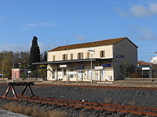
Borore
| Borore | ||
|---|---|---|

|
|
|
| Country | Italy | |
| region | Sardinia | |
| province | Nuoro (NU) | |
| Local name | Bòrore | |
| Coordinates | 40 ° 13 ' N , 8 ° 48' E | |
| surface | 42.74 km² | |
| Residents | 2,038 (Dec. 31, 2019) | |
| Population density | 48 inhabitants / km² | |
| Post Code | 08016 | |
| prefix | 0785 | |
| ISTAT number | 091011 | |
| Website | Borore | |

|
||
Borore is a place in the province of Nuoro in the Italian region of Sardinia with 2038 inhabitants (as of December 31, 2019).
Borore is 57 km west of Nuoro .
The neighboring municipalities are: Aidomaggiore ( OR ), Birori , Dualchi , Macomer , Norbello ( OR ), Santu Lussurgiu ( OR ), Scano di Montiferro ( OR ).
Attractions
Near Borore are the Domus de Janas di Putzu, the giant tombs Imbértighe , Preda Longa 'e figu and Santu Bainzu , the Menhirs of Busola , as well as the nuraghi Bighinzones, Dous Nuraghes, Imbértighe and Porcarzos .
traffic
railway station
Borore station is on the Cagliari – Golfo Aranci Marittima railway line .
Former airfield
One of the oldest airfields in Sardinia was located near Borore ( ⊙ ). It was set up in 1919 to handle air mail traffic between Cagliari- Monserrato and Sassari -Ottava and Terranova . In 1940 the Aero Club Cagliari was moved from Monserrato to Borore due to the Second World War for reasons of space and security, where it was active until 1942. From 1942 to 1944, Italian, German and Allied military squadrons used the airfield for a short time, after which it was orphaned for most of the time until it was officially closed in 1996. Horse races have been held on the site in recent years .
Individual evidence
- ↑ Statistiche demografiche ISTAT. Monthly population statistics of the Istituto Nazionale di Statistica , as of December 31 of 2019.
- ↑ Article in La Nuova Sardegna of August 20, 2013
- ↑ Details on the airmail service in Sardinia


