
Orosei
| Orosei | ||
|---|---|---|

|
|
|
| Country | Italy | |
| region | Sardinia | |
| province | Nuoro (NU) | |
| Local name | Orosei | |
| Coordinates | 40 ° 23 ' N , 9 ° 42' E | |
| height | 19 m slm | |
| surface | 90.43 km² | |
| Residents | 7,012 (Dec 31, 2019) | |
| Population density | 78 inhabitants / km² | |
| Factions | Cala Liberotto, Marina di Orosei, Sas Linnas Siccas, Sos Alinos | |
| Post Code | 08028 | |
| prefix | 0784 | |
| ISTAT number | 091063 | |
| Popular name | Oroseini | |
| Patron saint | San Giacomo Apostolo | |
| Website | Orosei | |
.JPG) View of Orosei |
||

Orosei is an Italian municipality in the province of Nuoro in Sardinia with 7012 inhabitants (as of December 31, 2019).
Geography and traffic
.JPG)
Orosei is on the SS 125 "Orientale Sarda" , the coastal road that connects Olbia with Cagliari . After the construction of the four-lane SS 131 , the SS 125 has largely lost its importance, which benefits the place. It is located in the delta of the Cedrino , on the east coast of Sardinia, about 3 km from the sea. After successfully eradicating malaria and regulating the river, Orosei developed rapidly from 1950. In 1931 there were around 2500 people in Orosei, but by 1970 there were already more than 4000 people.
history
The area around Orosei was, as some Domus de Janas testify, already settled in the Neolithic Age (4000-3000 BC). The nuraghi “Nurache'e Portu”, “Rampinu” and the well sanctuary Sa Linnarta prove that the area was also inhabited during the Bronze Age nuragic culture .
No traces of the presence of Phoenicians , Punic , Etruscans , Romans , Vandals and Byzantines could be found around Orosei, but Orosei existed in Roman times under the name "Fanum Orisi". Presumably, Etruscan ships have already docked in front of Posada to barter with the inhabitants of the Cedrino Valley. At the end of the 10th century, Orosei was part of the Gallura judiciary . In 1017 a Pisan fleet liberated the island, which had recently been occupied by the Arabs . The first documents that prove the existence of Orosei (called Orixi, Orisei, Ursey or Urisè in the sources) go back to 1173. In 1326 the Spaniards of the house of Aragon entered Orosei and introduced feudal rule . Until it was abolished in 1846, Orosei belonged to the "Baronia di Galtellì y Encontrada de Orosei".
In 1448 the area was bought by Baron Salvatore Guiso. From the 16th to the 18th century there were repeated attacks by pirates. In 1549, Muslim pirates almost completely destroyed Orosei. The heyday of port activity lasted from 1746 to 1782. In 1861 Sardinia and with it Orosei became part of Italy.
Until a few decades ago, the economy was mainly agricultural. The farmland in the delta of the Cedrino, which was regularly flooded, provided unusually fertile, easily irrigated soil. Since the marble and granite mining began in the 1950s, an industry has also developed that exports high-quality stone worldwide. From 1970 the tourist development began, so that Orosei's economy rests on three pillars.
Attractions
Orosei is part of the Gennargentu and Gulf of Orosei National Park , whose protected area includes both mountain and coastal zones. The beaches of Osalla and Cala Liberotto, Sas Linnas Siccas, Cala Ginepro , Sa Mattanosa and Bidderosa are particularly well known .

Chiesa di San Giacomo

Chiesa delle Anime

Chiesa di Sant 'Antonio Abate

Prigione vecchia, old prison

In the old City
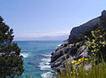
The coast of the Golfo di Orosei near Orosei

Beach at Marina di Orosei
.JPG)
.JPG)
.JPG)
.JPG)
.JPG)


Town twinning
Orosei lists the following two twin cities :
| city | country | since |
|---|---|---|
|
Marsciano |
|
1985 |
|
Tremblay-en-France |
|
1985 |
Web links
Individual evidence
- ↑ Statistiche demografiche ISTAT. Monthly population statistics of the Istituto Nazionale di Statistica , as of December 31 of 2019.
- ↑ Orosei.org. Retrieved October 23, 2017 .

Aritzo | Arzana | Atzara | Austis | Bari Sardo | Baunei | Belvì | Birori | Bitti | Bolotana | Borore | Bortigali | Cardedu | Desulo | Dorgali | Dualchi | Elini | Fonni | Gadoni | Gairo | Galtellì | Gavoi | Girasole | Ilbono | Irgoli | Jerzu | Lanusei | Lei | Loceri | Loculi | Lodine | Lodè | Lotzorai | Lula | Macomer | Mamoiada | Meana Sardo | Noragugume | Nuoro | Oliena | Ollolai | Olzai | Onani | Onifai | Oniferi | Orani | Orgosolo | Orosei | Orotelli | Ortueri | Orune | Osidda | Osini | Ottana | Ovodda | Perdasdefogu | Posada | Sarule | Silanus | Sindia | Siniscola | Sorgono | Talana | Tertenia | Teti | Tiana | Tonara | Torpè | Tortolì | Triei | Ulassai | Urzulei | Ussassai | Villagrande Strisaili