
Baunei
| Baunei | ||
|---|---|---|

|
|
|
| Country | Italy | |
| region | Sardinia | |
| province | Nuoro (NU) | |
| Local name | Baunei | |
| Coordinates | 40 ° 2 ′ N , 9 ° 40 ′ E | |
| height | 480 m slm | |
| surface | 216.45 km² | |
| Residents | 3,564 (Dec. 31, 2019) | |
| Population density | 16 inhabitants / km² | |
| Post Code | 08040 | |
| prefix | 0782 | |
| ISTAT number | 091006 | |
| Popular name | Baunesi | |
| Patron saint | San Nicola di Bari | |
| Website | Baunei | |
 View of Baunei |
||

Baunei is a municipality in the province of Nuoro in Sardinia with 3564 inhabitants (as of December 31, 2019).
Geographical location

Baunei is about 480 m above sea level on a rather steep southern slope. Above the village is a rock face through which a steep serpentine road winds to the Su Golgo plateau . The place is separated from the sea by a steep mountain range. Baunei is connected to Dorgali from the north by the winding coastal road SS125 , which continues in the south towards Lotzorai and Tortolì .
The neighboring communities are Dorgali, Lotzorai, Talana , Triei and Urzulei . The district of Santa Maria Navarrese by the sea belongs to Baunei .
Attractions
- To the south of the village a road branches off over the saddle and leads to a 128 m high rock needle called Pedra Longa ( Sardinian for "long rock") on the cliff. It has had the status of a natural monument since 1993 .
- The stalactite cave Grotta del Fico ( Sardinian for “fig tree grotto”) on the steep coast can only be reached from the sea .
- The beach of Cala Goloritzè can be reached by sea or by taking a long hike . Since 1993 it has had the status of a Natural Monument of the Sardinia Region, and in 1995 it was declared a National Italian Monument.
gallery
- Baunei

View of Baunei from the SS125

Pedra Longa
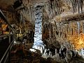
Grotta del Fico

At the Cala Goloritzè

L'Arco di Goloritzè rock gate

The district of Santa Maria Navarrese
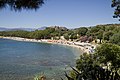
The beach of S. Maria Navarrese

.JPG)

.jpg)
.jpg)


.jpg)
Web links
Individual evidence
- ↑ Statistiche demografiche ISTAT. Monthly population statistics of the Istituto Nazionale di Statistica , as of December 31 of 2019.

Aritzo | Arzana | Atzara | Austis | Bari Sardo | Baunei | Belvì | Birori | Bitti | Bolotana | Borore | Bortigali | Cardedu | Desulo | Dorgali | Dualchi | Elini | Fonni | Gadoni | Gairo | Galtellì | Gavoi | Girasole | Ilbono | Irgoli | Jerzu | Lanusei | Lei | Loceri | Loculi | Lodine | Lodè | Lotzorai | Lula | Macomer | Mamoiada | Meana Sardo | Noragugume | Nuoro | Oliena | Ollolai | Olzai | Onani | Onifai | Oniferi | Orani | Orgosolo | Orosei | Orotelli | Ortueri | Orune | Osidda | Osini | Ottana | Ovodda | Perdasdefogu | Posada | Sarule | Silanus | Sindia | Siniscola | Sorgono | Talana | Tertenia | Teti | Tiana | Tonara | Torpè | Tortolì | Triei | Ulassai | Urzulei | Ussassai | Villagrande Strisaili