Gairo
| Gairo | ||
|---|---|---|

|
|
|
| Country | Italy | |
| region | Sardinia | |
| province | Nuoro (NU) | |
| Local name | Gàiru | |
| Coordinates | 39 ° 51 ' N , 9 ° 30' E | |
| height | 670 m slm | |
| surface | 78.46 km² | |
| Residents | 1,370 (Dec. 31, 2019) | |
| Population density | 17 inhabitants / km² | |
| Post Code | 08040 | |
| prefix | 0782 | |
| ISTAT number | 091026 | |
| Popular name | Gairesi | |
| Patron saint | Flavia Iulia Helena | |
| Website | Gairo | |
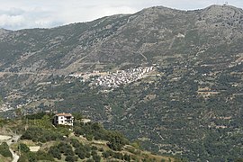
 View of Gairo ( Gairo Nuovo ) |
||
Gairo is an Italian municipality ( comune ) with 1370 inhabitants (as of December 31, 2019) in the province of Nuoro in Sardinia .
geography
The municipality is located about 16 kilometers southwest of Tortolì . The Pelau rises on the southeastern border of the municipality . With an exclave , the municipality is also located on the Tyrrhenian Sea (locality Coccorocci ).
history
In October 1951, the old town center, now called Gairo Vecchio , and the historic castle complex were almost completely destroyed by a flood and later abandoned in order to rebuild new houses above the half-destroyed village and on the coast. In contrast to Gairo Vecchio , today's place is also known as Gairo Nuovo or Gairo Sant'Elena . The current municipality of Cardedu emerged from the settlement on the coast in 1984 , which explains the year in the town's coat of arms.
traffic
The Strada Statale 198 di Seui e Lanusei runs through the municipality from Serri to Tortolì. Gairo has a station on the narrow-gauge Mandas – Arbatax railway , which is served by Trenino Verde in the summer months .
Web links
Individual evidence
- ↑ Statistiche demografiche ISTAT. Monthly population statistics of the Istituto Nazionale di Statistica , as of December 31 of 2019.


